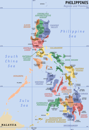
Territories claimed by the Philippines
The Philippines has claimed many territories throughout its history. These territories include the Spratly Islands, Sabah, Scarborough Shoal, Palmias (Miangas), Orchid Island, the Sangir Islands, the Marianas Islands, and the Caroline Islands.
Main territories claimed
Spratly Islands
The Philippines claims fifty-two landforms in the Spratly Island group. Of these fifty-two landforms, only five islands, two cays, and three reefs are under Philippine occupation: the Flat Island (Patag), the Loaita Island (Kota), the Nanshan Island (Lawak), the Thitu Island (Pagasa), the West York Island (Likas), the Lankiam Cay (Panata), the Northeast Cay (Parola), the Irving Reef (Balagtas), the Commodore Reef (Rizal), and the Second Thomas (Ayungin) Reef. Some of the other landforms claimed but not occupied by the Philippines as of now are either occupied by Vietnam, China, Taiwan or Malaysia. Landforms in the Spratly Islands group that have not been claimed by the Philippines are typically those that are closer to Vietnam. The farthest landform the Philippines claims is Ladd Reef, which is currently occupied by Vietnam.
The Philippines established a municipality in the province of Palawan named Kalayaan after all the landforms found on Pag-asa island,
North Borneo
_Sulu_(right)_Overbeck.jpg)
(Right) The second concession treaty was signed by Sultan Jamal ul-Azam of Sulu on 22 January 1878, also appointing Baron de Overbeck as Dato Bendahara and Raja Sandakan, approximately three weeks after signature of the first treaty.[2]
The Philippine government considers concession as "lease".
Between 1658 and 1700, the Sultanate of Sulu acquired the eastern part of the territory of Northern Borneo after helping the Bruneian forces settle a civil war. The Sulu Archipelago then came under the control of the Spanish while the area of Northern Borneo was administered by the British after the sultans of Brunei and Sulu agreed to cede their control. The western and eastern parts of Northern Borneo became known as North Borneo.[1][2]
In its process of decolonization beginning in 1946, Great Britain included Sabah in the newly formed Federation of Malaysia. The Philippines, which had already achieved its independence from the United States, protested the formation of Malaysia and filed claims for the whole territory of Northern Borneo under the administration of President Diosdado Macapagal. However, during a meeting to plan Maphilindo, the Philippine government stated that it had no objection to the formation of Malaysia, but claimed that the Sultan of Sulu wanted payment from the British government.[4] The first Malaysian Prime Minister, Tunku Abdul Rahman, said he would return to Kuala Lumpur to protest the Philippines' claim.[4]
Philippine President Ferdinand Marcos later revived the claim and trained a number of Moro fighters to reclaim the territory in a secret mission named Operation Merdeka.[5] However, when the recruits gained knowledge of their true mission, most of them demanded to be returned home, as they did not want to kill their fellow Muslims in Sabah.[6] Their request was denied; Marcos did not send back his soldiers but instead executed most of the fighters in an event known as the Jabidah massacre.[7] This caused a southern Philippines insurgency to emerge, and the claim continued to be escalated by other claimants from the defunct Sultanate of Sulu. These claimants each attempted to give themselves legitimacy by self-proclaiming as the new Sultan of Sulu with support from politicians in the Philippine central government wishing to incorporate Sabah into the Philippines. Most new claimants and Philippine politicians today use the promised Malaysian lease payment as their main reason to take over the territory and also use it as a reason before the International Court of Justice (ICJ).[4]
Scarborough Shoal
The Scarborough Shoal, more correctly described as a group of islands, atolls, and reefs rather than a shoal, is located in the South China Sea. The nearest landmass is Palauig town, Zambales province, Luzon Island, at 221 kilometres (137 mi). It is about 198 kilometres (123 mi) west of Subic Bay.
The Philippines and the People's Republic of China and Taiwan claim it.
In April 2012, the Philippines accused Chinese boats of fishing illegally and asked them to leave.
The Philippines is asserting jurisdiction over the shoal based on the juridical criteria established by public international law on the lawful methods for the acquisition of sovereignty. Among the criteria (effective occupation, cession, prescription, conquest, and accretion), the Philippines said that the country "exercised both effective occupation and effective jurisdiction over Bajo de Masinloc since its independence". Thus, it claims to have erected flags on some islands and a lighthouse which is reported to the International Maritime Organization. It also asserts that Philippine and US Naval Forces have used it as an impact range and that its Department of Environment and Natural Resources has conducted scientific, topographic and marine studies on the shoal, while Filipino fishermen regularly use it as a fishing ground and have always considered it their own.[8] Likewise, multiple engagements and arrests of Chinese fishermen were already made at the shoal by the Philippine Navy for using illegal fishing methods and catching of endangered sea species.[9]
The legal basis of the Philippine's assertion is based on the international law on acquisition of sovereignty. Thus, the Philippine government explains that its Exclusive Economic Zone (EEZ) claim on the waters around Scarborough Shoal is different from the sovereignty exercised by the Philippines on the shoal itself.
The Chinese basis for the claim is that the shoal would have been first discovered by Chinese in the 13th century and historically used by Chinese fishermen.
Palmas or Miangas Island
The Island of Palmas (or Miangas) was involved in a territorial dispute between the Netherlands and the United States which was heard by the Permanent Court of Arbitration.
This case is one of the most highly influential precedents dealing with island territorial conflicts.
Palmas, also referred to as Miangas, is an island of little economic value or strategic location. It is two miles in length, three-quarters of a mile in width, and had a population of about 750 when the decision of the arbitrator was handed down. The island is located between Mindanao, Philippines; and the northernmost island, known as Nanusa, of what was the former Netherlands East Indies. In 1898, Spain ceded the Philippines to the United States and Palmas sat within the boundaries of that cession to the U.S. In 1906, the United States discovered that the Netherlands also claimed sovereignty over the island and the two parties agreed to submit to binding arbitration to resolve the dispute on January 23, 1925. The arbitrator in the case was Max Huber, a Swiss national.
The question the arbitrator was to resolve was whether the Island of Palmas (Miangas), in its entirety, was a part of the territory of the United States or the Netherlands. The arbitrator ruled in favor of the Netherlands' position and stated that the Netherlands held the actual title to Palmas.
In the first of the United States' two arguments, it claimed to hold the island because it had received the actual title through legitimate treaties from the original "discoverer" of the island, Spain. The United States argued that Spain acquired the title to Palmas when she discovered the island and that the island was terra nullius. Spain's title to the island, because it was part of the Philippines, was then ceded to the United States in the 1898 Treaty of Paris (1898) after Spain's defeat in the Spanish–American War. The arbitrator noted that no new international law invalidated the legal transfer of territory via cession.
However, the arbitrator noted that Spain could not legally grant what it did not hold and that the Treaty of Paris could not grant Palmas to the United States if Spain had no actual title to it. The arbitrator concluded that Spain held an inchoate title when Spain "discovered" Palmas. However, for a sovereign to maintain its initial title via discovery, the arbitrator said that the discoverer had to actually exercise authority, even if it was a simple act such as planting a flag on the beach. In this case, Spain did not exercise authority over the island after making an initial claim after discovery, so the United States' claim was based on relatively weak grounds.
The United States also argued that Palmas was United States' territory because the island was closer to the Philippines than to Indonesia, which was then held by the Netherlands East Indies. The arbitrator said there was no positive international law which favored the United States' approach of terra firma, where the nearest continent or island of considerable size gives title to the land in dispute. The arbitrator held that mere proximity was not an adequate claim to land, noting that if the international community followed the proposed United States approach, it would lead to arbitrary results.
The Netherlands' primary contention was that it held actual title because she had exercised authority on the island since 1677. The arbitrator noted that the United States had failed to show documentation proving Spanish sovereignty on the island except those documents that specifically mentioned the island's discovery. Additionally, there was no evidence that Palmas was a part of the judicial or administrative organization of the Spanish government of the Philippines. However, the Netherlands showed that the East India Company had negotiated treaties with the local princes of the island since the 17th century and had exercised sovereignty, including a requirement of Protestantism and the denial of other nationals on the island. The arbitrator pointed out that if Spain had actually exercised authority, then there would have been conflicts between the two countries but none were provided in the evidence.
Impact and legacy
Under the Palmas decision, three important rules for resolving island territorial disputes were decided:
Firstly, a title based on contiguity has no standing in international law. Secondly, a title by discovery is inchoate. Finally, if another sovereign begins to exercise continuous and actual sovereignty, and the arbitrator required that the claim had to be open and public and with good title, and the discoverer does not contest this claim, the claim by the sovereign that exercises authority is greater than a title based on mere discovery.
However, to this day, several Philippine legislators claim that the island cannot be part of Indonesia today because the ethnic group living in this island is far more related by language to the Sarangani people of Mindanao than any ethnic group in Indonesia (e.g., Minahasa). However this is not entirely true, since languages spoken in Miangas such as Sangir and Talaud are also spoken in the North Sulawesi province by a significant number of people.
Currently, the Philippine government has no desire to contest the sovereignty of the Indonesian Government over Miangas Island and respects the Indonesian administration over the island.
References
- Rozan Yunos (September 21, 2008). "How Brunei lost its northern province". The Brunei Times. Archived from the original on June 17, 2014. Retrieved October 28, 2013.
- Rozan Yunos (March 7, 2013). "Sabah and the Sulu claims". The Brunei Times. Archived from the original on June 17, 2014. Retrieved September 20, 2013.
- Mohamad, Kadir (2009). "Malaysia's territorial disputes – two cases at the ICJ : Batu Puteh, Middle Rocks and South Ledge (Malaysia/Singapore), Ligitan and Sipadan [and the Sabah claim] (Malaysia/Indonesia/Philippines)" (PDF). Institute of Diplomacy and Foreign Relations (IDFR) Ministry of Foreign Affairs, Malaysia: 46. Archived (PDF) from the original on May 16, 2016. Retrieved May 16, 2014.
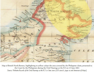
Map of British North Borneo, highlighting in yellow colour the area covered by the Philippine claim, presented to the Court by the Philippines during the Oral Hearings at the ICJ on 25 June 2001
Cite journal requires|journal=(help) - "Why 'Sultan' is dreaming". Daily Express. March 27, 2013. Archived from the original on March 28, 2013. Retrieved March 27, 2013.
- "Marcos order: Destabilize, take Sabah". Philippine Daily Inquirer. April 2, 2000. Retrieved November 16, 2016.
- Acram Latiph (March 13, 2013). "Sabah – the question that won't go away". New Mandala. Archived from the original on September 23, 2016. Retrieved November 16, 2016.
- Paul F. Whitman (2002). "The Corregidor Massacre - 1968". Corregidor Historic Society. Archived from the original on September 13, 2015. Retrieved September 13, 2015.
- "Pinoy fishermen successfully return from Scarborough fishing trip". abs-cbd.com. Archived from the original on June 19, 2018. Retrieved January 4, 2019.
- "Palace: Philippines has sovereignty over Scarborough". philstar.com. Retrieved January 4, 2019.
Further reading
- Lowell B. Bautista (2008). "The Historical Context and Legal Basis of the Philippine Treaty Limits" (PDF). Asian-Pacific Law & Policy Journal. Archived from the original (PDF) on October 11, 2010.
- Bautista, Lowell B. (February 2012). "The Implications of Recent Decisions on the Territorial and Maritime Boundary Disputes in East and Southeast Asia". maritime energy resources in asia Legal Regimes and Cooperation : NBR Special Report #37. Academia.edu.
- Bautista, Lowell B. (January 1, 2010). "The Legal Status of the Philippine Treaty Limits In International Law". Academia.edu. doi:10.1007/s12180-009-0003-5.
- Bautista, Lowell B. (Fall 2009). "The Historical Background, Geographical Extent and Legal Bases of the Philippine Territorial Water Claim". The Journal of Comparative Asian Development.