Greater Nepal
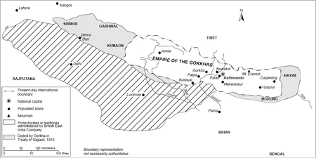
Greater Nepal is a nascent irredentist concept[1] of Nepal extending beyond its present boundaries to include current Indian territories controlled by the Gurkha army after defeating some neighbouring kingdoms in wars fought from 1791 to 1804 but ceded to the East India Company under the Sugauli Treaty after the Gurkha king was defeated in the 1814–16 Anglo-Nepalese War. The concept of "Greater Nepal" does not include those parts of Tibet that the Gurkha army occupied very briefly after defeating Tibetans in wars fought from 1789 to 1791 but from where the Gurkha army was ejected by Chinese army which defeated the Gurkha king in 1792 Sino-Nepalese War.[1] In 1813, this historical "Greater Nepal" extended from the Sutlej to the Teesta River, spanning 1,500 km. Rule over this expanse was brief, however, and in the aftermath of the 1814-1815 war with the East India Company the Gorkhali realm was whittled down considerably. The real time Gorkhali presence in Garhwal was for 12 years,Kumaon for 24 years[2],and Sikkim for 33 years. The Treaty of Sugauli, between the Gorkhali king and the Company, was ratified in 1816. It caused Nepal's rulers to lose about 105,000 km2 of territory and left Nepal as it is today, with 147,181 km2 of present total area.
Part of a series on the |
|---|
| History of Nepal |
 |
|
| Timeline |
|
|
History
The kingdom of Prithvi Narayan Shah (1723–75) of the Shah dynasty was confined to the small Gorkha region of present day Nepal and had an area of just 2,500 square kilometres (970 sq mi). He decided to enlarge it by defeating neighbouring principalities.
Campaigns by Shah kings
Prithvi Narayan Shah (1723–75) decided to enlarge his kingdom that was confined to the small Gorkha region of present day Nepal and had an area of just 2,500 square kilometres (970 sq mi). He defeated major principalities in wars and unified them under his rule starting from the 1740s ending with shifting of his Gorkha Kingdom’s capital from Gorkha region to Kathmandu in 1769. He then attacked and absorbed dozens of other small principalities and gave a new name "Nepal" to his Gorkha kingdom. After his death in 1775, his eldest son Pratap Singh Shah continued defeating other smaller princes and absorbing their fiefdoms. Pratap Shah died at the age of twenty-five in 1777. Then Prithvi Narayan Shah’s second son, Bahadur Shah, ruled until 1794.[3]
Wars with kingdoms in neighbouring countries (India and Tibet)
Prithvi Narayan Shah’s second son, Bahadur Shah, wanted Nepal to become a pan-Himalayan kingdom and started demanding that kings of all the hill kingdoms in the Himalayas surrender to him. He won all small kingdoms up to Kali River in the west. He turned his attention to kingdoms in neighbouring India across the Kali River and attacked them when they rebuffed him. He defeated some of them in wars and won some areas. However, the next Shah soon lost them to the British East India Company which had come to rule much of north India by then and had become the de facto ruler of India east of Satluj river in place of the Moghuls, Marathas and other kings, especially after defeating the Marathas in 1803 in Second Anglo-Maratha War.
Bahadur Shah also attacked Tibet in 1789-1792 to control the trade routes through the mountains and the trade itself due to a dispute over contaminated silver coins and had initial success but was defeated by the Chinese who intervened in favour of Tibet. The Chinese pushed the Gorkha army back almost to the doors of Kathmandu and a desperate Bahadur Shah appealed to the British East India Company for guns and help in saving his kingdom. Thus Bahadur Shah lost his northwards gambit in Tibet but his successor kings continued their attempts westward towards Kangra and eastward in Sikkim because the Sikkim army under its king Chogyal was not as powerful as the Chinese army.
Victory over Kumaon, Garhwal and Kangra kingdoms
The Gorkha army invaded Kumaon Kingdom and occupied it in 1790–91. [4][5] Then the Gorkha army invaded Garhwal Kingdom and occupied it in 1804 after defeating its King Pradyuman Shah. In 1806, the Gorkha army absorbed all the small kingdoms like Sirmudh state, Hindur and Besahar lying across the Garhwal and up to Satluj River. In this way, the Gorkhas occupied the hilly regions such as Nainital, Almora and Dehradun without crossing the Satluj River. However, when the Gorkhas crossed the Satluj river, the Gorkha's attack on Kangra and siege of Kangra Fort west of Satluj river was repulsed by the Kangra king with help from Maharaja Ranjit Singh of Punjab in 1809.
Victory over Sikkim and Darjeeling
Previously Darjeeling formed a part of dominions of the Raja of Sikkim, who had been engaged in an unsuccessful warfare against the Gorkhas. From 1780 the Gorkhas continually made inroads into Sikkim. In the Sino-Nepal treaty, Sikkim lost some of its land to Nepal and by the beginning of the 19th century, the Gorkhas had overrun Sikkim as far-eastward as the Teesta and had conquered and annexed the Terai.[6]
Historical boundaries
Before Gorkha king Prithvi Narayan Shah started attacking and defeating other principalities and established Nepal as a country in 1769, there was no Nepal as it is known today. Nepal’s western boundary was east of Kali River when his second son, Bahadur Shah, thought of making Nepal a pan-Himalayan kingdom. Bahadur Shah and his successors won kingdoms west of Kali River after 1790 and extended Nepal’s boundaries westward to beyond Satluj River until the tide turned in 1809 and Kangra king repulsed Gorkha army eastward with help from Maharaja Ranjit Singh. In the east, Nepal’s boundary extended to Teesta River. The southern border was the Siwan district of Bihar and the southern border of Nepal extended to Allahabad after absorption of Palpa Kingdom, including the Terai sector of Butwal taken by the king of Palpa from the king of Awadh on lease in 1801.
Sugauli Treaty
The East India Company had come to rule much of north India by the time the Gurkhas attacked kingdoms in India. The Company became the de-facto ruler of India east of Satluj river in place of the Moghuls, Marathas and other kings, especially after defeating the Marathas in 1803 in Second Anglo-Maratha War. After firmly establishing its rule over Delhi in 1803, the Company attacked the Gorkhas, defeated them in 1814–15 Anglo-Nepalese War and ejected them from Kumaon Kingdom and Garhwal Kingdom in the area west of Kali river and in Sikkim and north Bengal east of Teesta river by 1815. The Gorkhas were forced to accept a peace treaty with the British (the Sugauli Treaty) in March 1816 just as they had been forced to a peace treaty with the Chinese (the Sino-Nepalese Treaty) in 1792 and ceded to East India Company the territories in India they had won since 1791.
The British restored some Terai area to Nepal in December 1816. The Sugauli Treaty was superseded in December 1923 by a "Treaty of Perpetual Peace and Friendship."
15 November 1860 treaty (Ratified)
After the Nepali army helped the British suppress the Indian Rebellion of 1857, the British government (that had taken control over India from East India Company in 1858) in recognition of this support returned some Terai lands lying between the Rapti and Mahakali Rivers to Nepal in 1860. These lands were surveyed by Commissioners appointed for the survey by the British government in presence of the Commissioners deputed by the Nepal Durbar; masonry pillars were erected to mark the agreed boundary of Nepal and British India and the territory was formally delivered over to the Nepali Durbar. A treaty was signed between the King of Nepal (by Maharaja Jung Bahadur Rana, on behalf of Maharajah Dheraj Soorinder (sic) Vikram Sah) and the British government on 1 November 1860 to secure the agreed boundaries.
Article 3 of the 1860 treaty stated "The boundary line surveyed by the British Commissioners appointed for the purpose extending eastward from the River Kali or Sardah to the foot of the hills north of Bagowra Tal, and marked by pillars, shall henceforth be the boundary between the British Province of Oudh and the Territories of the Maharajah of Nipal."
The other territories in India that the Gurkha army had occupied briefly between 1791 and 1814 but lost in 1814–16 remained in India after transfer of some territories to Nepal in 1860 as per the treaty.
Official position of Nepal government and political parties
The former kings of Nepal and prime ministers of Kingdom of Nepal have never discussed or approved of the concept of "Greater Nepal". Thereafter the prime ministers of Federal Democratic Republic of Nepal have never discussed or approved of the concept of "Greater Nepal".
Upon forming a coalition government after the 2008 Nepalese Constituent Assembly election, the leader of the Communist Party of Nepal (Maoist) Pushpa Kamal Dahal (who had spent 10 years of his life in India after being declared a terrorist by the Nepalese government) said on 24 April 2008 that the 1950 Indo-Nepal Treaty of Peace and Friendship would be scrapped.[7] However, he soon realised and the matter was not pursued afterwards as he resigned as Prime Minister after nine months in charge due to other reasons. He also said in an interview with Times of India in 2005 that Greater Nepal was a "media-created stunt".[1][8]. Late Nepali Prime Minister Girija Prasad Koirala told journalists in Jalapa that the Greater Nepal idea is "a product of unstable minds".[9]
Present-day view
There is no official claim by the Government of Nepal or any political party of Nepal to take back the territory ceded to British East India Company by Nepal which is now territory of Republic of India but there is a NGO Named; Greater Nepal Nationalist Front(GNLF) whose Creater is Mr. Phanindra Nepal. There are also some major Nepali political parties which are formed with a view to achieve Greater Nepal.
See also
References
- "Nepal Maoists produce maps to claim parts of India". Times of India. 25 October 2005. Retrieved 13 December 2012.
- Pande, Puran Ch (1998). The Himalayan Environment: Issues and Challenges. Daya Publishing House. ISBN 978-81-7035-187-0.
- "Timeline of the Unification of Nepal (1744-1791)". Karma99. Retrieved 9 July 2017.
- "Kumaon and Garhwal Coin History - Uttarakhand Worldwide - Excerpts from the history of Uttaranchal Through Coins". Archived from the original on 2017-09-07. Retrieved 2010-10-12.
- "The Enclosing of Nepal". U.S. Library of Congress. countrystudies.us. Retrieved 30 November 2010.
- "History - Pre-Independence". darjeeling.gov.in. Retrieved 30 November 2010.
- Maoists to scrap 1950 Indo-Nepal Friendship Treaty
- Pervez Iqbal Siddiqui (25 October 2005). "Nepal Maoists claim parts of India". Times of India.
- http://www.himalmag.com/component/content/article/3045-.html
External links
- "Important Dates in the History of Uttarakhand". Bell Infotech Systems. Archived from the original on 20 December 2016.
- Border Nepal – Border Management of Nepal
- "The Gurkhas – origin, exploration and expansion". Darjeeling Times. 16 April 2011. Archived from the original on 3 November 2013.
- "Greater Nepal official site" (in Nepali).
- "History of Nepal in Map" (in Nepali).