Miangas
Miangas or Palmas is North Sulawesi's northernmost island, and one of 92 officially listed outlying islands of Indonesia.
| Native name: Pulau Miangas | |
|---|---|
 Wolo Beach on Miangas | |
 Miangas Location of Miangas in Indonesia | |
| Geography | |
| Location | Southeast Asia |
| Coordinates | 5.5672°N 126.5817°E |
| Archipelago | Talaud Islands |
| Area | 3.15 km2 (1.22 sq mi) |
| Length | 3 km (1.9 mi)23 |
| Width | 1.2 km (0.75 mi)23 |
| Highest elevation | 111 m (364 ft) |
| Highest point | Gunung Batu |
| Administration | |
Indonesia | |
| Province | North Sulawesi |
| Regency | Talaud Islands |
| Demographics | |
| Population | 728 (2010) |
| Additional information | |
| Time zone | |
Etymology
Miangas means "exposed to piracy", because pirates from Mindanao used to visit the island.[1] In the 16th century, the island was named in Spanish Isla de las Palmas, and in Portuguese Ilha de Palmeiras.[2] In the Sasahara language,[lower-alpha 1] the island is called Tinonda or Poilaten in Minahasan which mean "people who live separated from the main archipelago" and "our island" respectively.[3]
History
According to local tradition, there were a number of kingdoms in the area. Sangir, Talaud and Sitaro belonged to two kingdoms, Tabukan and Kalongan. To justify their sovereignty over Miangas, the Dutch argued that the island had been under the domination of the princes of Sangir.[4]
First Europeans
In October 1526, Garcia Jofre de Loaísa, Spanish sailor and researcher, was the first European to visit the island.[5]
The island was used as a defense site by Talaud people when under attack from the Sulu Sultanate.[6]
The island was affected by the outbreak of cholera in 1885, causing hundreds of the inhabitants to move to Karakelang Island.[7]
In 1895, E. J. Jellesma, Oud-resident of Manado, visited Miangas to praise the residents and kapiten laut for rejecting the Spanish flag. Jellesma gave them a medal and a Dutch flag. With Jellesma was Pastor Kroll, who baptized 254 residents as Protestants. After Jellesma's visit, a Tahuna assistant resident and Pastor Pannings visited the island in April and October 1909.[8]
Island of Palmas Case
According to the Treaty of Paris, the Philippines area was all areas within a large geographic box. Miangas lay inside the southern boundary of the box. On 21 January 1906, General Leonard Wood, Governor General of Moro, officially visited the island for the first time.[9][10] He found the Dutch flag already flew there and that the island was claimed as part of the Dutch East Indies.[11] When Wood returned to Zamboanga, he reported it to the United States Military Secretary, on 26 January 1906. The United States government referred the matter to the Netherlands through their embassy in The Hague on 31 March 1906. On 17 October 1906 the Netherlands Foreign Ministry responded with reasons why the island was included in the Dutch East Indies.[12] On 23 January 1925 the Netherlands and the United States brought the case to the Permanent Court of Arbitration, under a sole arbitrator Max Huber of Switzerland.[10][13] On 4 April 1928 Huber decided that the island "forms in its entirety a part of Netherlands territory".[14][15][16]
It was reported in 2003 that Philippine congressman Harry Roque argues that Spain could not have legally ceded Palmas or any part of the Philippines to the United States because Filipinos had already established the Republic of the Philippines on June 12, 1898 before the Treaty of Paris was signed on Dec. 10, 1898.[17]
Post Indonesian independence
On 4 July 1956, Indonesia, represented by Ambassador Soehardjo Wirjopranoto, and the Philippines, represented by Ambassador Jose T. Fuentebella, signed the Agreement on Immigration Between the Republic of the Philippines and the Republic of Indonesia, that allowed border residents in Sangihe, Talaud, Nunukan, Balut, and Sarangani, who had a laissez-passer, to cross the border to trade, visit family, worship, and travel. On 16 September 1965, Jusuf Ronodipuro of Indonesia and Leon T. Garcia of the Philippines signed a Directives and Guidelines on the Implementation of the Immigration Agreement on Repatriation and Border Crossing Arrangement Between Republic of Indonesia and the Republic of the Philippines, which clarify the first agreement, making Marore, Miangas, Mabila, and Balut the checkpoints.[18]
In 1972, the island was hit by a tsunami, and 90 householders were moved by the government to Bolaang-Mongondow Regency as a result.[7]
In 2005, the Indonesian government refused a shipping line from Miangas to Davao (part of the Philippines). In the same year, Miangas Village Secretary Jhonlyi Awala died from a beating at the hands of the Chief of Police of Miangas. About 200 people, dressed in black, demonstrated to express their outrage at the senseless death and the island's neglect by the Indonesian state. They lowered the Indonesian flag at the Miangas pier and instead raised the Philippine flag. Talaud Regent Elly Engelbert Lasut, who arrived from Manado, de-escalated the situation.[19]
According to Ministry of Foreign Affairs (Indonesia), Philippine Tourism Authority in February 2009 published a map which included Miangas into the Philippines' territory.[20]
A monument, named Monumen Patung Santiago (Monument Statue of Santiago), was built on the island in 2010 to commemorate Santiago who defended the island from the Dutch colonials.[6][21] In 2011, the island could be reached by ship operated by Pelni.[22]
Starting from 12 March 2017, a flight from Manado serves this island once a week. The flight, operated by Wings Air, lands at Miangas Airport every Sunday.[23]
Geography
Miangas is located 521 km (324 mi) from Manado, the capital of North Sulawesi and 126 km (78 mi) from Davao City in the Philippines.[24] It also lies 80 km (50 mi) southeast of Mindanao.[11] It is 3 km (2 mi) long and 1.2 km (3⁄4 mi) wide,[25] with an area of 3.15 km2.[20] Miangas, which lies to the north of the Nanusa Islands, forms a separate district within the Talaud Islands Regency.[22][26] The island is mainly lowland, about 1.5 metres above sea level. The highest point, called Gunung Batu, is 111 metres high, located in the northeast part of the island. This area is covered with coconut palm. In the northeast corner of the island, there is a 46-metre-high (151 ft) cliff, with the northeast shore fringed by a 320 m (0.2 mi) reef.[27]
Transportation
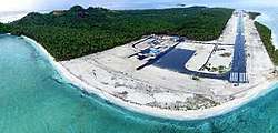
For transportation, Miangas inhabitants once relied on their homemade sailboats. During the New Order, however, they started using motorboats. These are now the main sources of transportation.[28] In October 2016, Miangas Airport inaugurated by the President Joko Widodo. An inaugural flight serves this airport some months later.[29][30]
Economy
Miangas inhabitants derive their main income from fishing. Women also weave mats from pandan leaves.[31]
Demography
As at the 2010 Census, the island's population was 728 people.[20] Miangas inhabitants speak Indonesian and Bisaya; the older generation usually also speak Tagalog.[1][6]
The island has a police station and two military posts. There are also a market, a harbor office and a bank office.[6]
Notes
- Sasahara language or sea language is a language that is used by Sangi people while sailing.
References
- Notes
- Ganesan & Amer 2010, p. 297
- Ulaen, Wulandari & Tangkilisan 2012, pp. 10–11
- Ulaen, Wulandari & Tangkilisan 2012, pp. 14–15
- M. P. H. Roessingh, "Dutch relations with the Philippines:a survey of sources in the General States Archives, The Hague, Netherlands", Asian Studies 5, No. 2, pp. 377-407
- Ulaen, Wulandari & Tangkilisan 2012, p. 10
- Raharjo, Sandy Nur Ikfal (17 January 2012). "Menilik Perbatasan Indonesia-Filipina: Pulau Miangas". LIPI. Retrieved 16 June 2012.
- Ulaen, Wulandari & Tangkilisan 2012, p. 139
- Ulaen, Wulandari & Tangkilisan 2012, pp. 61–62
- Ulaen, Wulandari & Tangkilisan 2012, p. 84
- Hong & van Dyke 2009, p. 139
- Rothwell et al. 2010, p. 272
- Ulaen, Wulandari & Tangkilisan 2012, pp. 84–85
- Ulaen, Wulandari & Tangkilisan 2012, p. 85
- Huber, Max (4 April 1928). "Island of Palmas (or Miangas) (The United States of America v. The Netherlands)". PCA Case Repository. The Hague: Permanent Court of Arbitration. Retrieved 8 October 2016.
- "Island of Palmas Case" (pdf). Reports of International Arbitral Awards. II: 829–871. 4 April 1928.
- Ulaen, Wulandari & Tangkilisan 2012, p. 86
- "Special Report: The legal battle for Palmas island (conclusion)". The Philippine Star. February 3, 2003.
- Ulaen, Wulandari & Tangkilisan 2012, pp. 121–123
- Velasco, Djorina (28 January 2007). "Between Manado and Davao: How the Indonesian island of Miangas is making use of its Philippine ties". News Break Archives. Public Trust Media Group. Retrieved 20 February 2017.
- "Private mapmaker suspected in border blunder". The Jakarta Post. 14 February 2009. Retrieved 15 June 2012.
- Agus Setiawan, ed. (23 April 2010). "Patung Santiago : Simbol NKRI di Pulau Miangas". Antara News. Retrieved 16 June 2012.
- Harsaputra, Indra (28 June 2011). "Two ports to become world-class harbors". The Jakarta Post. Retrieved 15 June 2012.
- "Wings Air to Open Inaugural Flight to Miangas". Antaranews.com (in Indonesian). Retrieved 24 June 2018.
- Ganesan & Amer 2010, p. 293
- Hong & van Dyke 2009, p. 94
- "KM Sangiang-Berlayar Hingga Tapal Batas Miangas KM Sangiang-Berlayar Hingga Tapal Batas Miangas". Pelni. 19 May 2011. Archived from the original on 15 October 2012. Retrieved 15 June 2012.
- National Geospatial-intelligence Agency 2004, p. 3
- Ulaen, Wulandari & Tangkilisan 2012, pp. 137–138
- "President inaugurates airport in Miangas". Indonesian Benelux Chamber of Commerce. Retrieved 18 July 2017.
- "Wings Air Flies Inaugural Flight to Miangas Island". netralnews.com. Retrieved 18 July 2017.
- Ulaen, Wulandari & Tangkilisan 2012, pp. 136–137
- Bibliography
- Ganesan, N.; Amer, Ramses (2010). International Relations in Southeast Asia: Between Bilateralism and Multilateralism. Singapore: ISEAS Publishing. ISBN 9789814279574.CS1 maint: ref=harv (link)
- Hong, Seoung-Yong; van Dyke, Jon M. (2009). Maritime Boundary Disputes, Settlement Processes, and the Law of the Sea. Publications on Ocean Development. 65. Martinus Nijhoff Publishers. ISBN 9789004173439.CS1 maint: ref=harv (link)
- National Geospatial-intelligence Agency (2004). Prostar Sailing Directions 2004 New Guinea Enroute (9th ed.). ProStar Publications. ISBN 9781577855699.CS1 maint: ref=harv (link)
- Rothwell, Donald R.; Kaye, Stuart; Akhtarkhavari, Afshin; Davis, Ruth (2010). International Law: Cases and Materials With Australian Perspectives. Melbourne, Victoria: Cambridge University Press. ISBN 9780521609111.CS1 maint: ref=harv (link)
- Ulaen, Alex J.; Wulandari, Triana; Tangkilisan, Yuda B. (2012). Sejarah Wilayah Perbatasan: Miangas - Filipina 1928 - 2010 Dua Nama Satu Juragan. Jakarta: Gramata Publishing. ISBN 9786028986496.CS1 maint: ref=harv (link)
| Wikimedia Commons has media related to Miangas. |
| Authority control |
|
|---|