Nine-dash line
The nine-dash line—at various times also referred to as the ten-dash line and the eleven-dash line—refers to the undefined,[1] vaguely located, demarcation line used by the People's Republic of China (PRC) and the Republic of China (ROC) , for their claims of the major part of the South China Sea.[2][3] The contested area in the South China Sea includes the Paracel Islands,[lower-alpha 1] the Spratly Islands,[lower-alpha 2][4] and various other areas including the Pratas Islands, the Macclesfield Bank and the Scarborough Shoal. The claim encompasses the area of Chinese land reclamation known as the "Great Wall of Sand".[5][6][7][8]
| Nine-dash line | |||||||
|---|---|---|---|---|---|---|---|
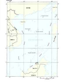
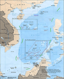 The nine-dash line (highlighted in green) | |||||||
| Traditional Chinese | 九段線 | ||||||
| Simplified Chinese | 九段线 | ||||||
| Literal meaning | Nine-Segment Line | ||||||
| |||||||
An early map showing a U-shaped eleven-dash line was published in the then-Republic of China on 1 December 1947.[9] Two of the dashes in the Gulf of Tonkin were later removed at the behest of Chinese Premier Zhou Enlai, reducing the total to nine. Chinese scholars asserted at the time that the version of the map with nine dashes represented the maximum extent of historical claims to the area.[10] In 2010, the PRC published a new national map which incorporated a tenth dash. Subsequent editions added a dash to the other end of the line, extending it into the East China Sea.[11]
Despite having made the vague claim public in 1947, China has not (as of 2018) filed a formal and specifically defined claim to the area within the dashes.[12] China added a tenth dash to the east of Taiwan island in 2013 as a part of its official sovereignty claim to the disputed territories in the South China Sea.[11][13][14]
On 12 July 2016, an arbitral tribunal constituted under Annex VII to the 1982 United Nations Convention on the Law of the Sea ruled that China has no legal basis to claim "historic rights" within its nine-dash line in a case brought by the Philippines. The tribunal judged that there was no evidence that China had historically exercised exclusive control over the waters or resources within the nine-dash line. The ruling was rejected by both the PRC and ROC governments.[15][16]
History
After being defeated in the Sino-French War in 1885, China signed the Treaty of Tientsin with France, and renounced the suzerainty over Vietnam. On June 26, 1887, the Qing government signed the Convention Relating to the Delimitation of the Frontier between China and Tonkin, which did not clarify the water border between China and French Indo-China.[17][18]
Following the defeat of Japan at the end of World War II, the Republic of China claimed the entirety of the Paracels, Pratas and Spratly Islands after accepting the Japanese surrender of the islands based on the Cairo and Potsdam Declarations.[19] However, under the 1943 Cairo Declaration and 1945 Potsdam Proclamation, the Republic of China's sovereignty over the archipelagos and waters of South China Sea was not stated.[20]
In November 1946, the Republic of China sent naval ships to take control of these islands after the surrender of Japan. When the Peace Treaty with Japan was being signed at the San Francisco Conference, on 7 September 1951, both China and Vietnam asserted their rights to the islands. Later the Philippine government also laid claim to some islands of the archipelagos.[21]
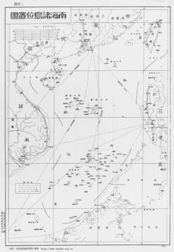
The nine-dash line was originally an eleven-dash line first shown on a map published by the government of the then Republic of China in December 1947 to justify its claims in the South China Sea.[10] The 1947 map, titled "Map of South China Sea Islands", originated from an earlier one titled "Map of Chinese Islands in the South China Sea" (中国南海岛屿图) published by the Republic of China's Land and Water Maps Inspection Committee in 1935.[13] In 1949, the newly established People's Republic of China dropped claims in the Gulf of Tonkin, and the eleven dashes was revised to nine.[22][23]
After evacuating to Taiwan, the Government of Republic of China has continued its claims, and the nine-dash line remains as the rationale for Taiwan's claims to the Spratly and Paracel Islands. Under President Lee Teng-hui, Republic of China (R.O.C) stated that "legally, historically, geographically, or in reality", all of the South China Sea and Spratly islands were R.O.C's territory and under R.O.C sovereignty, and denounced actions undertaken there by Malaysia and the Philippines, in a statement on 13 July 1999 released by the foreign ministry of Taiwan.[24] Taiwan and China's claims mirror each other.[25] During international talks involving the Spratly islands, P.R.C and R.O.C have cooperated with each other since both have the same claims.[25][26]
The Republic of China (Taiwan) rejected all rival claims to the Paracel islands, repeating its position that all of the Paracel, Spratly, Zhongsha (Macclesfield Bank grouped with Scarborough Shoal) and Pratas Islands Islands belong to the Republic of China along with "their surrounding waters and respective seabed and subsoil", and that Taiwan views other claims as illegitimate, in a statement released by Taiwan's Ministry of Foreign Affairs which added "There is no doubt that the Republic of China has sovereignty over the archipelagos and waters."[28]
The nine-dash line has been used by China to show the maximum extent of its claim without indicating how the dashes would be joined if it was continuous and how that would affect the extent of the area claimed by China.[10] The Philippines, Vietnam, Malaysia, Brunei and Indonesia have all officially protested over the use of such a line.[29] Immediately after China submitted a map to the UN including the nine-dash line's territorial claim in the South China Sea on 7 May 2009, the Philippines lodged a diplomatic protest against China for claiming the whole of South China Sea illegally. Vietnam and Malaysia filed their joint protest a day after China submitted its map to the UN. Indonesia also registered its protest, even though it did not have a claim on the South China Sea.[4]
In 2013 the PRC extended their claims with a new ten-dash map. The "new" dash, however, is to the east of Taiwan and not in the South China Sea.[11]
Although China has not provided an official account, the first dashed-line map is widely reported by scholars and commentators to pre-date the existence of the People's Republic of China, having been published in 1947 by the Nationalist government of the Republic of China. That map, which shows 11 dashes. Scholarly accounts indicate that the 1947 map, titled "Map of South China Sea Islands", originated from an earlier one titled "Map of Chinese Islands in the South China Sea" (Zhongguo nanhai daoyu tu) published by the Republic of China's Land and Water Maps Inspection Committee in 1935, and that Chinese maps produced after the establishment of the People's Republic of China in 1949 "appear to follow the old maps". The maps published by the People's Republic of China, however, removed the two dashes originally depicted inside the Gulf of Tonkin. Although not visible on the 2009 map, modern Chinese maps since at least 1984, including the vertically oriented maps published by China in 2013 and 2014 also include a tenth dash located to the east of Taiwan.[27]
Ongoing disputes
According to former Philippine President Benigno Aquino III, "China's nine-dash line territorial claim over the entire South China Sea is against international laws, particularly the United Nations Convention of the Laws of the Sea (UNCLOS)".[30] Vietnam also rejected the Chinese claim, citing that it is baseless and against the UNCLOS.[31] In 2010, at a regional conference in Hanoi, United States Secretary of State Hillary Clinton announced that "The United States has a national interest in freedom of navigation, open access to Asia's maritime commons, and respect for international law in the South China Sea".[32] The United States has also called for unfettered access to the area that China claims as its own, and accused Beijing of adopting an increasingly aggressive stance on the high seas.[32]
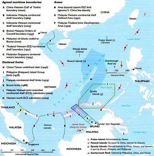
Parts of China's nine-dash line overlap Indonesia's exclusive economic zone near the Natuna islands. Indonesia believes China's claim over parts of the Natuna islands has no legal basis. In November 2015, Indonesia's security chief Luhut Panjaitan said Indonesia could take China before an international court if Beijing's claim to the majority of the South China Sea and part of Indonesian territory is not resolved through dialogue.[33] As early as 1958, the Chinese government released a document pertaining to its territorial limits,[34] stating that China's territorial waters cover twelve nautical miles, and announcing that this provision applies to "all the territory of People's Republic of China, including the Chinese mainland and offshore islands, Taiwan and its surrounding islands, the Penghu Islands, the Dongsha Islands, Xisha Islands, Zhongsha Islands, the Nansha Islands and other islands belonging to China".[35][36]
Some parties have questioned the jurisdiction of the United Nations Convention of the Laws of the Sea on the dispute, arguing that the convention does not support claims based on sovereignty or title, and instead raises the right to continue using the waters for traditional purpose.[37][38]
While China has never used the nine-dash line as an inviolable border to its sovereignty,[40] this strategy together with the fact that China's government has never officially explained the meaning of the line has led many researchers to try to derive the exact meanings of the Nine-Dash Map in the Chinese strategy in the South China Sea. Some scholars believe that this line cannot be considered as a maritime boundary line because it violates maritime laws, which states that a national boundary line must be a stable and defined one. The nine-dash line is not stable because it has been reduced from eleven to nine dashes in the Gulf of Tonkin as endorsed by Zhou Enlai without any reasons given. It is also not a defined line because it does not have any specific geographic coordinates and does not tell how it can be connected if it was a continuous line.[41]
A study of the Office of Ocean and Polar Affairs, US Department of State in 2014 said about a possible interpretation that "the placement of the dashes within open ocean space would suggest a maritime boundary or limit".[27]
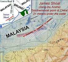
A 2012 Chinese eighth-grade geography textbook includes a map of China with the nine-dash line and the text "The southernmost point of our country's territory is Zengmu Ansha (James Shoal) in the Nansha Islands." Shan Zhiqiang, the executive chief editor of the Chinese National Geography magazine, wrote in 2013: "The nine-dashed line ... is now deeply engraved in the hearts and minds of the Chinese people."[42]
In October 2008, the website WikiLeaks published a cable from the US Embassy in Beijing reporting that Yin Wenqiang, a senior Chinese government maritime law expert, had "admitted" he was unaware of the historical basis for the nine dashes.[43]
According to the Kyodo News, in March 2010 PRC officials told US officials that they consider the South China Sea a "core interest" on par with Taiwan, Tibet and Xinjiang,[44] but subsequently backed away from that assertion[45][46][47] In July 2010 the Communist Party-controlled Global Times stated that "China will never waive its right to protect its core interest with military means"[48] and a Ministry of Defense spokesman said that "China has indisputable sovereignty of the South Sea and China has sufficient historical and legal backing" to underpin its claims.[49]
At the Conference on Maritime Study organised by the US-based Center for Strategic and International Studies (CSIS) in June 2011, Su Hao of the China Foreign Affairs University in Beijing delivered a speech on China's sovereignty and policy in the South China Sea, using history as the main argument. However, Termsak Chalermpalanupap, Assistant Director for Program Coordination and External Relations of the ASEAN Secretariat, said: “I don’t think that the 1982 United Nations Convention on the Law of the Sea (UNCLOS) recognizes history as the basis to make sovereignty claims". Peter Dutton of the US Naval War College agreed, saying, "The jurisdiction over waters does not have connection to history. It must observe the UNCLOS." Dutton stressed that using history to explain sovereignty erodes the rules of the UNCLOS.[50] It is understood that China ratified the UNCLOS in 1996.[51]
Maritime researcher Carlyle Thayer, Emeritus Professor of Politics of the University of New South Wales, said that Chinese scholars using historical heritage to explain its claim of sovereignty shows the lack of legal foundation under the international law for the claim.[52] Caitlyn Antrim, Executive Director, Rule of Law Committee for the Oceans of the US, commented that "The U-shaped line has no ground under the international law because [the] historical basis is very weak". She added "I don't understand what China claims for in that U-shaped line. If they claim sovereignty over islands inside that line, the question is whether they are able to prove their sovereignty over these islands. If China claimed sovereignty over these islands 500 years ago and then they did not perform their sovereignty, their claim of sovereignty becomes very weak. For uninhabited islands, they can only claim territorial seas, not exclusive economic zones (EEZ) from the islands".[50]
Arbitral tribunal's ruling
In January 2013, the Philippines formally initiated arbitration proceedings against China's territorial claim on the "nine-dash line", which it said is unlawful under the United Nations Convention on the Law of the Sea (UNCLOS) convention. China however refused to participate in the arbitration.[53][54] An arbitration tribunal was constituted under Annex VII of UNCLOS and it was decided in July 2013 that the Permanent Court of Arbitration (PCA) would function as registry in the proceedings.[55]
On 12 July 2016, the five arbitrators of the tribunal agreed unanimously with the Philippines. They concluded in the award that there was no evidence that China had historically exercised exclusive control over the waters or resources, hence there was "no legal basis for China to claim historic rights" over the nine-dash line.[56][57] The tribunal also judged that China had violated the Philippines' sovereign rights and caused "severe harm to the coral reef environment".[15][58] China however rejected the ruling, calling it "ill-founded"; the China's paramount leader Xi Jinping said that "China's territorial sovereignty and marine rights in the South China Sea will not be affected by the so-called Philippines South China Sea ruling in any way", but China was still "committed to resolving disputes" with its neighbours.[15][59] Taiwan, which currently administers Taiping Island which is the largest of the Spratly Islands, also rejected the ruling.[16]
In popular culture
The DreamWorks Animation film Abominable included a map with the nine-dash line, which generated controversy in Vietnam, Philippines and Malaysia although the film was simply depicting maps as sold in China.[60]
When ESPN hosted The Jump in China, the map they used depicted the nine-dash line, which caused controversy.[61]
See also
| Wikimedia Commons has media related to China's nine-dash demarcation line. |
Notes
- The Paracel Islands are occupied by the PRC, but are also claimed by Vietnam and the ROC.
- The Spratly Islands are disputed by the Philippines, PRC, ROC, Brunei, Malaysia, and Vietnam, who each claim either part or all the islands, which are believed (hoped) to sit on vast mineral resources, including oil and gas.
References
Citations
- Raul (Pete) Pedrozo (19 August 2014). "China versus Vietnam: An Analysis of the Competing Claims in the South China Sea". Archived from the original on 11 October 2017. Retrieved 11 October 2017.
- Martin Riegl, Jakub Landovský, Irina Valko, eds. (26 November 2014). Strategic Regions in 21st Century Power Politics. Cambridge Scholars Publishing. pp. 66–68. ISBN 9781443871341. Archived from the original on 4 September 2015. Retrieved 19 July 2015.CS1 maint: uses editors parameter (link)
- Michaela del Callar (26 July 2013). "China's new '10-dash line map' eats into Philippine territory". GMA News. Archived from the original on 22 July 2015. Retrieved 19 July 2015.
- Jamandre, Tessa (14 April 2011). "PH protests China's '9-dash line' Spratlys claim". Malaya. Archived from the original on 19 April 2011. Retrieved 2 June 2011.
- "China building 'great wall of sand' in South China Sea". BBC. 1 April 2015. Archived from the original on 5 April 2015. Retrieved 22 May 2015.
- "US Navy: Beijing creating a 'great wall of sand' in South China Sea". The Guardian. 31 March 2015. Archived from the original on 22 May 2015. Retrieved 22 May 2015.
- "China building a 'great wall of sand' in South China Sea– US Navy". RT. 31 March 2015. Archived from the original on 22 May 2015. Retrieved 22 May 2015.
- Marcus, Jonathan (29 May 2015). "US-China tensions rise over Beijing's 'Great Wall of Sand'". BBC. Archived from the original on 29 May 2015. Retrieved 29 May 2015.
- Wu 2013, p. 79(at History of the U-shaped line)
- Brown, Peter J. (8 December 2009). "Calculated ambiguity in the South China Sea". Asia Times. Archived from the original on 5 January 2010. Retrieved 18 May 2020.
- Euan Graham. "China's New Map: Just Another Dash?". RUSI. Archived from the original on 29 September 2013.
- Cheney-Peters, Scott (14 December 2014). "China's Nine-Dashed Line faces renewed assault". Archived from the original on 11 July 2016. Retrieved 15 December 2014.
- "Limits in the Seas" (PDF). Office of Ocean and Polar Affairs, U.S. Department of State. Archived (PDF) from the original on 20 February 2020. Retrieved 23 May 2019.
- "New ten-dashed line map revealed China's ambition". 19 July 2014. Archived from the original on 25 July 2015. Retrieved 25 July 2015.
- "South China Sea: Tribunal backs case against China brought by Philippines". BBC News. 12 July 2016. Archived from the original on 20 June 2018. Retrieved 22 June 2018.
- Jun Mai, Shi Jiangtao (12 July 2016). "Taiwan-controlled Taiping Island is a rock, says international court in South China Sea ruling". South China Morning Post. Archived from the original on 15 July 2016. Retrieved 13 July 2016.CS1 maint: uses authors parameter (link)
- Convention Relative à la Délimitation de la Frontière entre la Chine et le Tonkin Archived 4 September 2011 at the Wayback Machinelink=
- Shen, Guchao (December 2000). "On "the Historical Waters" of Beibu Gulf" (PDF). China's Borderland History and Geography Studies. 10 (4): 44. Archived (PDF) from the original on 9 December 2018. Retrieved 8 December 2018.
- Gao, Zhiguo; Jia, Bing Bing (January 2013). "The nine-dash line in the South China Sea: history, status, and implications". American Journal of International Law: 98.
- Florian, Dupuy; Pierre, Marie (January 2013). "A Legal Analysis of China's Historic Rights Claim in the South China Sea": 124. Cite journal requires
|journal=(help) - Chen, King C. (1979). China's War with Vietnam, 1979: Issues, Decisions, and Implications. Hoover Press. p. 43. ISBN 0817985719. Archived from the original on 26 February 2020. Retrieved 5 August 2016.
- Beech, Hannah (19 July 2016). "Just Where Exactly Did China Get the South China Sea Nine-Dash Line From?". Time. Archived from the original on 27 November 2018. Retrieved 18 November 2018.
- "History the Weak Link in Beijing's Maritime Claims". The Diplomat. Archived from the original on 18 November 2018. Retrieved 18 November 2018.
- STRATFOR's Global Intelligence Update (14 July 1999). "Taiwan sticks to its guns, to U.S. chagrin". Asia Times. Archived from the original on 25 March 2014. Retrieved 10 March 2014.
- Sisci, Francesco (29 June 2010). "US toe-dipping muddies South China Sea". Asia Times. Archived from the original on 10 July 2013. Retrieved 14 May 2014.
- Pak 2000 Archived 10 June 2016 at the Wayback Machine, p. 91.
- Baumert, Kevin; Melchior, Brian (5 December 2014). "Limits in the seas No. 143. China. Maritime claims in the South China sea" (PDF). Office of Ocean and Polar Affairs, Bureau of Oceans and International Environmental and Scientific Affairs, United States Department of State. Archived (PDF) from the original on 20 February 2020. Retrieved 23 May 2019.

- "Taiwan reiterates Paracel Islands sovereignty claim" Archived 16 October 2015 at the Wayback Machine. Taipei Times. 11 May 2014, p. 3
- Esplanada, Jerry E. (15 April 2011). "PH runs to UN to protest China's '9-dash line' Spratlys claim". Archived from the original on 17 April 2011. Retrieved 20 June 2011.
- Bengco, Regina (2 June 2011). "Aquino mulls UN protest on Spratlys". Maritime Security Asia. Archived from the original on 14 January 2013. Retrieved 12 June 2011.
- Hoang Viet (19 May 2009). "Is the Ox's tongue line legal?". BBC. Archived from the original on 27 November 2010. Retrieved 12 June 2011.
- "Beijing hits out at US comments on South China Sea". Agence-France Presse. 25 July 2010. Archived from the original on 24 March 2012. Retrieved 20 June 2011.
- "Indonesia says could also take China to court over South China Sea". Reuters. 11 November 2015. Archived from the original on 17 June 2017. Retrieved 1 July 2017.
- "Annex 2/5: Declaration of the Government of the People's Republic of China on China's Territorial Sea". fmprc.gov.cn. Ministry of Foreign Affairs of the People's Republic of China (FMPRC). 4 September 1958. Archived from the original on 24 September 2015. Retrieved 8 July 2015.
- "The Operation of the HYSY 981 Drilling Rig: Vietnam's Provocation and China's Position". 16 July 2014. Archived from the original on 8 September 2015. Retrieved 30 June 2015.
- "1958 'The People's Republic of China government's statement on the Territorial Sea' study". 24 January 2003. Archived from the original on 18 January 2010.
- Sourabh Gupta, Samuels International (11 January 2015). "Why US analysis of China's nine-dash line is flawed". Archived from the original on 29 June 2015. Retrieved 30 June 2015.
- Sourabh Gupta (15 December 2014). "Testing China's – and the State Department's -nine-dash line claims" (PDF). Archived (PDF) from the original on 4 March 2016. Retrieved 30 June 2015.
- "CML/17/2009 – Submission by the PRC to the UN Commission on the Limits of the Continental shelf" (PDF). United Nations. 7 May 2009. Archived from the original (PDF) on 29 May 2009. Retrieved 20 February 2015.
- Tsirbas, Marina (2 June 2016). "What Does the Nine-Dash Line Actually Mean?". The Diplomat. Archived from the original on 18 November 2018. Retrieved 18 November 2018.
- Foreign Press Center of Vietnam (25 July 2010). "The "9-dashed line" – an irrational claim". Archived from the original on 21 July 2011. Retrieved 20 June 2011.
- Zheng Wang. "The Nine-Dashed Line: 'Engraved in Our Hearts'". The Diplomat. Archived from the original on 20 May 2016. Retrieved 16 May 2016.
- "Analysis: China's nine-dashed line in [the] South China Sea". Reuters. 25 May 2012. Archived from the original on 26 February 2014. Retrieved 3 February 2014.
- "Clinton Signals US Role in China Territorial Disputes After Asean Talks", Bloomberg.com, Bloomberg, 23 July 2010, archived from the original on 10 January 2014, retrieved 10 March 2017
- Wong, Edward (30 March 2011). "China Hedges Over Whether South China Sea Is a 'Core Interest' Worth War". The New York Times. Archived from the original on 29 June 2012. Retrieved 25 February 2017.
- "Armed Clash in the South China Sea – Council on Foreign Relations". Cfr.org. Archived from the original on 5 September 2012. Retrieved 15 April 2014.
- "U.S. sees crisis fears easing over South China Sea". Reuters. Archived from the original on 10 January 2014. Retrieved 15 April 2014.
- "American shadow over South China Sea", Global Times, 26 July 2010, archived from the original on 29 July 2010
- "China Says Its South Sea Claims Are 'Indisputable'", Bloomberg.com, Bloomberg, 29 July 2010, archived from the original on 4 July 2014, retrieved 10 March 2017
- "International scholars discuss maritime security in the East Sea". vietnamne. 22 June 2011. Archived from the original on 13 October 2014.
- "Declarations or Statements upon UNCLOS Ratification". Division for Ocean Affairs and the Law of the Sea, United Nations Office of Legal Affairs. Archived from the original on 6 February 2013. Retrieved 22 February 2013.
- Thayer, Carlyle A. (14 July 2011). "South China Sea disputes: ASEAN and China". Archived from the original on 23 April 2013. Retrieved 22 February 2013.
- "Timeline: South China Sea dispute". Financial Times. 12 July 2016. Archived from the original on 14 December 2016. Retrieved 12 July 2016.
- Beech, Hannah (11 July 2016). "China's Global Reputation Hinges on Upcoming South China Sea Court Decision". Time. Archived from the original on 13 July 2016. Retrieved 12 July 2016.
- "Press Release: Arbitration between the Republic of the Philippines and the People's Republic of China: Arbitral Tribunal Establishes Rules of Procedure and Initial Timetable". PCAcases.com. 27 August 2013. Archived from the original on 21 July 2016. Retrieved 13 July 2016.
- "Press Release: The South China Sea Arbitration (The Republic of the Philippines v. The People's Republic of China)" (PDF). PCA. 12 July 2016. Archived from the original (PDF) on 12 July 2016. Retrieved 13 July 2016.
- "A UN-appointed tribunal dismisses China's claims in the South China Sea". The Economist. 12 July 2016. Archived from the original on 13 September 2017. Retrieved 6 September 2017.
- Perez, Jane (12 July 2016). "Beijing's South China Sea Claims Rejected by Hague Tribunal". The New York Times. Archived from the original on 13 July 2016. Retrieved 25 February 2017.
- Tom Phillips, Oliver Holmes, Owen Bowcott (12 July 2016). "Beijing rejects tribunal's ruling in South China Sea case". The Guardian. Archived from the original on 12 July 2016. Retrieved 13 July 2016.CS1 maint: uses authors parameter (link)
- Reuters (18 October 2019). "Abominable: anger grows over controversial map in Chinese children's film". The Guardian. Archived from the original on 18 October 2019. Retrieved 18 October 2019.
- Crossley, Gabriel (10 October 2019). "ESPN criticised over China-NBA coverage for using 'nine-dash line' map". Reuters. Archived from the original on 19 October 2019. Retrieved 27 October 2019.
Sources
| Library resources about Nine-dash line |
- Wu, Shicun (2013). Solving Disputes for Regional Cooperation and Development in the South China Sea: A Chinese Perspective. Chandos Asian Studies Series. Elsevier Reed. ISBN 978-1780633558.CS1 maint: ref=harv (link)
External links
- China's 2009 two-page document submission to the U.N. introducing the nine-dash line map (archived here)
| Related articles | |||||||||||
|---|---|---|---|---|---|---|---|---|---|---|---|
| Confrontations |
| ||||||||||
| Regions | |||||||||||
| Occupied features | |||||||||||
| Unoccupied features | |||||||||||
.svg.png)