San Mateo, California
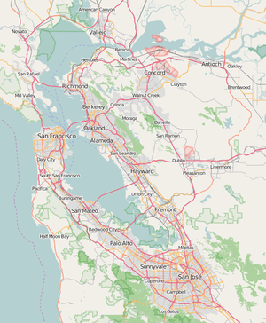
San Mateo (/ˌsæn məˈteɪ.oʊ/ SAN mə-TAY-oh; Spanish for '"Saint Matthew"') is a city in San Mateo County, California, approximately 20 miles (32 km) south of San Francisco, and 31 miles (50 km) northwest of San Jose. San Mateo had an estimated 2019 population of 104,430.[7] It has a Mediterranean climate, and is known for its rich history. The biggest economic contributors to the city include the Medical Center, one of the local school districts, and Sony's Sony Interactive Entertainment division. Finally, being in the center of the San Francisco Bay Area, it has many ways to travel back and forth beween the major cities of that area.
San Mateo, California | |
|---|---|
City | |
| City of San Mateo | |
 | |
 Seal | |
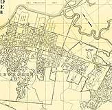
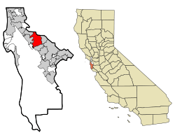 Location in San Mateo County and the state of California | |
 San Mateo, California Location in San Francisco Bay Area  San Mateo, California Location in California  San Mateo, California Location in the United States | |
| Coordinates: 37°33′15″N 122°18′47″W | |
| Country | |
| State | |
| County | San Mateo |
| Incorporated | September 4, 1894[1] |
| Named for | St. Matthew |
| Government | |
| • Mayor | Joe Goethals[2] |
| • City manager | Drew Corbett[3] |
| Area | |
| • Total | 15.88 sq mi (41.14 km2) |
| • Land | 12.13 sq mi (31.42 km2) |
| • Water | 3.75 sq mi (9.72 km2) 23.63% |
| Elevation | 46 ft (14 m) |
| Population | |
| • Total | 97,207 |
| • Estimate (2019)[7] | 104,430 |
| • Rank | 68th in California 298th in the United States |
| • Density | 8,570.40/sq mi (3,309.14/km2) |
| Time zone | UTC−8 (Pacific) |
| • Summer (DST) | UTC−7 (PDT) |
| ZIP codes[8] | 94401–94404, 94497 |
| Area code | 650 |
| FIPS code | 06-68252 |
| GNIS feature IDs | 1659584, 2411800 |
| Website | www |
History
Documented by Spanish colonists as part of the Rancho de las Pulgas (literally "Ranch of the Fleas") and the Rancho San Mateo, the earliest history is held in the archives of Mission Dolores. In 1789 the Spanish missionaries had named a Native American village along Laurel Creek as Los Laureles or the Laurels (Mission Dolores, 1789). At the time of Mexican Independence, there were 30 native Californians at San Mateo, most likely from the Ssalson tribelet.[9]
Captain Fredrick W. Beechey in 1827 traveling with the hills on their right, known in that part as the Sierra del Sur, began to approach the road, which passing over a small eminence, opened out upon "a wide country of meadow land, with clusters of fine oak free from underwood… It strongly resembled a nobleman's park: herds of cattle and horses were grazing upon the rich pasture, and numerous fallow‑deer, startled at the approach of strangers, bounded off to seek protection among the hills… This spot is named San Matheo, and belongs to the mission of San Francisco."[9] An 1835 sketch map of the Rancho refers to the creek as Arroyo de Los Laureles. In the 21st century, most of the laurels are gone, having been removed for development.
In 1810 Coyote Point was an early recorded feature of San Mateo. Beginning in the 1850s, some wealthy San Franciscans began building summer or permanent homes in the milder mid-peninsula. While most of this early settlement occurred in adjacent Hillsborough and Burlingame, a number of historically important mansions and buildings were constructed in San Mateo.
A.P. Giannini, founder of the Bank of Italy (which later became the Bank of America), lived here most of his life. His mansion, Seven Oaks, is listed in the National Register of Historic Places (No.99001181). Located at 20 El Cerrito Avenue, it has been deteriorating as it has not been preserved or occupied for years.
In 1858 Sun Water Station, a stage station of the Butterfield Overland Mail route, was established in San Mateo. It was located 9 miles south of Clarks Station in what is now San Bruno and 9 miles north of the next station at Redwood City.[10]
The Howard Estate was built in 1859 on the hill accessed by Crystal Springs Road. The Parrott Estate was erected in 1860 in the same area, giving rise to two conflicting names for the hill, Howard Hill and Parrot Hill. After use of the automobile changed traffic patterns, neither historic name was commonly applied to that hill (Brown, 1975). The Borel Estate was developed near Borel Creek in 1874. It has been redeveloped since the late 20th century for use as modern offices and shops. The property is managed and owned by Borel Place Associates and the Borel Estate Company.
Hayward Park, the 1880 American Queen Anne-style residence of Alvinza Hayward (often said to be "California's first millionaire" from his silver and banking fortunes), was built on an 800-acre (3.2 km2) estate in San Mateo which included a deer park and racetrack, roughly bounded by present-day El Camino Real (on the west), 9th Avenue (on the north), B Street (on the east) and 16th Avenue (on the south).[11] A smaller portion of the property and the mansion, was converted into The Peninsula Hotel in 1908, following Hayward's death in 1904. The Hotel burned down in a spectacular fire on 25 June 1920.[12]


In the early 20th century, Japanese immigrants came to San Mateo to work in the salt ponds and flower industry. Although Japanese-Americans only account for 2.2% of the population today, they continue to be a major cultural influence and a draw for the rest of the region.[13] The Eugene J. De Sabla Japanese Teahouse and Garden was established in 1894 at 70 De Sabla Road, designed by Makoto Hagiwara, designer of the Japanese garden in Golden Gate Park in San Francisco. He arranged for Japanese artisans to be brought to the United States primarily for its teahouse construction. The parcel was purchased in 1988 by San Francisco businessman Achille Paladini and wife Joan, who have restored it. The garden features hundreds of varieties of plants and several rare trees. A large koi pond surrounds an island. The property was placed on the National Register of Historic Places in 1992.[14]
In December 1967, Sgt. Joe Artavia, then serving in Vietnam with Alpha Company, 1st Battalion, 327th Infantry Regiment of the 101st Airborne Division wrote to his sister, Linda Giese, who was a resident of San Carlos working in San Mateo,[15] asking if San Mateo or San Francisco could adopt the Company, saying that it would bring "the morale of the guys up as high as the clouds".[16] San Mateo passed a resolution on March 4, 1968, officially adopting Alpha Company and letters and gifts began arriving from the citizens of San Mateo.[15][17] Joe would be killed in action on March 24, 1968, less than three weeks after the resolution.[18] Linda would travel to Vietnam to meet with the men of Alpha Company for Christmas in 1968 and deliver personalized medallions from the City of San Mateo.[15][19] In 1972, San Mateo requested and received permission to have Alpha Company visit the city when they left Vietnam, later holding a parade in January 1972, believed to be the only parade honoring the military during the Vietnam War.[15] In 1988, Joseph Brazan wrote a screenplay entitled A Dove Among Eagles chronicling the adoption of Alpha Company by San Mateo and the real-life romance between Linda and Artavia's commander, Lt. Stephen Patterson.[20] The city expanded its support to the entire 1st Battalion in 1991, when they were deployed to Kuwait under Operation Desert Storm.[15]
Geography
San Mateo is located at 37°33′15″N 122°18′47″W (37.554286, −122.313044).[21] According to the United States Census Bureau, the city has a total area of 15.9 square miles (41 km2), of which, 12.1 square miles (31 km2) is land and 3.8 square miles (9.8 km2) (23.63%) is water.
The best-known natural area is Coyote Point Park, a rock outcropped peninsula that juts out into the San Francisco Bay. The early Spanish navigators named it la punta de San Mateo.[22] Crews of American cargo ships carrying grain in the bay renamed it Big Coyote (BLM, 1853). Sailors had a penchant for naming promontories at the edge of San Francisco Bay after the coyote; across the bay in Fremont are the Coyote Hills, part of Coyote Hills Regional Park. By the 1890s the shore area was developed as a popular beach called San Mateo Beach. In 1842 the Spanish had named it playa de San Mateo. Today Coyote Point is home to CuriOdyssey, formerly known as the Coyote Point Museum, a major natural history museums and wildlife centers in the state. The Peninsula Humane Society is also situated at Coyote Point.
The variety of natural habitats includes mixed oak woodland, riparian zones, and bayland marshes. One endangered species, the California clapper rail, was sighted feeding on mudflats by the Third Avenue bridge in San Mateo.[23] The marsh areas are also likely habitat for the endangered Salt Marsh Harvest Mouse, which inhabit the middle and high zones of salt and brackish marshes, as well as for the endangered marsh plant, Point Reyes bird's beak.
.jpg) Aerial view of Coyote Point Park, directed northeast. Prominent landmarks include Bayshore Freeway (diagonal, foreground) and the Bay Bridge (background).
Aerial view of Coyote Point Park, directed northeast. Prominent landmarks include Bayshore Freeway (diagonal, foreground) and the Bay Bridge (background). View of San Francisco Bay, directed north from Seal Point Park.
.jpg) Laurelwood Park and Sugarloaf Mountain
Laurelwood Park and Sugarloaf Mountain.jpg) Sawyer Camp Trail (2014)
Sawyer Camp Trail (2014)
Sugarloaf Mountain, whose name has been documented in 1870, is a prominent landform between the forks of Laurel Creek (Brown, 1975). In the late 20th century, this mixed oak woodland and chaparral habitat was a site of controversy related to proposals to develop a portion of the mountain for residential use. It has been preserved for use as park and open space area, and is home to the endangered Mission Blue Butterfly.
Sawyer Camp Trail, located on the western edge of San Mateo along the Crystal Springs Reservoir is another popular destination for joggers, walkers and bikers. This roughly 6 mile trail begins in San Mateo and stretches north toward Hillsborough and San Bruno, parallel to the 280 freeway.
Climate
San Mateo has a Mediterranean climate with warm, dry summers and mild, damp winters. The city is generally shielded from the Pacific Ocean by the Montara Mountain block of the Santa Cruz Mountains, but two gaps in the mountains (the San Bruno Gap, between Montara Mountain and San Bruno Mountain; and the Crystal Springs Gap, near where State Route 92 meets State Route 35, west of the College of San Mateo) can channel ocean weather, resulting in gusty afternoon winds that bring fog toward San Mateo in the late afternoon through early morning in the summer months.[24][25]
The National Weather Service maintained a cooperative weather station in San Mateo until 1978; records for the period show that January, the coolest month, had an average maximum of 57.8 °F (14.3 °C) and an average minimum of 41.7 °F (5.4 °C), and September, the warmest month, had an average maximum of 78.0 °F (25.6 °C) and an average minimum of 54.2 °F (12.3 °C). The record maximum temperature was 109 °F (43 °C) on June 14, 1961, and the record minimum temperature was 25 °F (−4 °C) on January 5, 1949, and December 9, 1972. Annual precipitation averaged 18.77 inches (477 mm) of rainfall, falling on an average of 60 days each year. The wettest year was 29.77 inches (756 mm) in 1973 and the driest year was 11.16 inches (283 mm) of rainfall in 1953. The most precipitation in one month was 12.59 inches (320 mm) of rainfall in December 1955 and the most precipitation in 24 hours was 3.72 inches (94 mm) of rainfall on December 23, 1955.[26] Based on comparison with the existing NWS office at San Francisco International Airport, San Mateo is generally a few degrees warmer in summer than the airport and a few degrees cooler in winter, while annual precipitation is almost the same at the airport and in San Mateo.[27] In recent years, daily temperature reports for San Mateo from local weather observers have been published in the San Mateo Times and the San Francisco Chronicle.
| Climate data for San Mateo | |||||||||||||
|---|---|---|---|---|---|---|---|---|---|---|---|---|---|
| Month | Jan | Feb | Mar | Apr | May | Jun | Jul | Aug | Sep | Oct | Nov | Dec | Year |
| Record high °F (°C) | 76 (24) |
80 (27) |
89 (32) |
97 (36) |
102 (39) |
109 (43) |
110 (43) |
105 (41) |
106 (41) |
104 (40) |
87 (31) |
76 (24) |
110 (43) |
| Average high °F (°C) | 55 (13) |
67 (19) |
65 (18) |
69 (21) |
74 (23) |
76 (24) |
77 (25) |
77 (25) |
76 (24) |
74 (23) |
65 (18) |
58 (14) |
69 (21) |
| Average low °F (°C) | 40 (4) |
43 (6) |
45 (7) |
46 (8) |
50 (10) |
54 (12) |
56 (13) |
56 (13) |
54 (12) |
50 (10) |
44 (7) |
40 (4) |
48 (9) |
| Record low °F (°C) | 16 (−9) |
25 (−4) |
29 (−2) |
33 (1) |
36 (2) |
39 (4) |
40 (4) |
43 (6) |
38 (3) |
33 (1) |
29 (−2) |
19 (−7) |
16 (−9) |
| Average rainfall inches (mm) | 4.02 (102) |
4.09 (104) |
3.13 (80) |
1.16 (29) |
0.47 (12) |
0.10 (2.5) |
0 (0) |
0.05 (1.3) |
0.16 (4.1) |
1.06 (27) |
2.37 (60) |
3.84 (98) |
20.45 (519.9) |
| Source: [28] | |||||||||||||
Demographics
| Historical population | |||
|---|---|---|---|
| Census | Pop. | %± | |
| 1880 | 932 | — | |
| 1900 | 1,832 | — | |
| 1910 | 4,384 | 139.3% | |
| 1920 | 5,979 | 36.4% | |
| 1930 | 13,444 | 124.9% | |
| 1940 | 19,403 | 44.3% | |
| 1950 | 41,782 | 115.3% | |
| 1960 | 69,870 | 67.2% | |
| 1970 | 78,991 | 13.1% | |
| 1980 | 77,640 | −1.7% | |
| 1990 | 85,486 | 10.1% | |
| 2000 | 92,482 | 8.2% | |
| 2010 | 97,207 | 5.1% | |
| Est. 2019 | 104,430 | [7] | 7.4% |
| U.S. Decennial Census[29] | |||
The 2010 United States Census[30] reported that San Mateo had a population of 97,207. The population density was 8,013.8 people per square mile (3,094.2/km2). The racial makeup of San Mateo was 56,214 (46.8%) White, 2,296 (2.4%) African American, 505 (0.5%) Native American, 18,384 (18.9%) Asian (7.9% Chinese, 4.6% Filipino, 2.2% Japanese, 1.8% Indian, 0.8% Korean, 0.3% Vietnamese, 0.2% Thai), 1,998 (2.1%) Pacific Islander (1.2% Tongan, 0.3% Fijian, 0.2% Samoan, 0.1% Hawaiian,), 12,264 (12.6%) from other races, and 5,546 (5.7%) from two or more races. Hispanic or Latino of any race were 25,815 persons (26.6%); 14.4% of San Mateo is Mexican, 2.8% Guatemalan, 2.6% Salvadoran, 1.2% Peruvian, 0.9% Nicaraguan, 0.5% Puerto Rican, 0.3% Colombian, 0.3% Chilean, 0.2% Honduran, and 0.2% Cuban.
The Census reported that 95,891 people (98.6% of the population) lived in households, 975 (1.0%) lived in non-institutionalized group quarters, and 341 (0.4%) were institutionalized.
There were 38,233 households, out of which 11,464 (30.0%) had children under the age of 18 living in them, 17,964 (47.0%) were opposite-sex married couples living together, 3,824 (10.0%) had a female householder with no husband present, 1,656 (4.3%) had a male householder with no wife present. There were 2,098 (5.5%) unmarried opposite-sex partnerships, and 343 (0.9%) same-sex married couples or partnerships. 11,751 households (30.7%) were made up of individuals, and 4,391 (11.5%) had someone living alone who was 65 years of age or older. The average household size was 2.51. There were 23,444 families (61.3% of all households); the average family size was 3.14.
The population was spread out, with 20,254 people (20.8%) under the age of 18, 6,915 people (7.1%) aged 18 to 24, 30,772 people (31.7%) aged 25 to 44, 25,286 people (26.0%) aged 45 to 64, and 13,980 people (14.4%) who were 65 years of age or older. The median age was 38.9 years. For every 100 females, there were 95.4 males. For every 100 females age 18 and over, there were 92.8 males.
There were 40,014 housing units at an average density of 3,298.8 per square mile (1,273.7/km2), of which 19,969 (52.2%) were owner-occupied, and 18,264 (47.8%) were occupied by renters. The homeowner vacancy rate was 1.5%; the rental vacancy rate was 3.7%. Of the population, 50,951 people (52.4%) lived in owner-occupied housing units and 44,940 people (46.2%) lived in rental housing units.
According to the 2011 American Community Survey 5-Year estimate,[31] the median income for a household in the city was $86,772, and the median income for a family was $107,023. Males had a median income of $65,541 versus $60,491 for females. The per capita income for the city was $25,248. About 3.6% of families and 5.9% of the population were below the poverty line, including 6.1% of those under age 18 and 5.9% of those age 65 or over.
|
Government
San Mateo is structured as a council-manager form of government. The City Council has five members elected every two years to staggered four-year terms.[33]
In the California State Legislature, San Mateo is in the 13th Senate District, represented by Democrat Jerry Hill, and in the 22nd Assembly District, represented by Democrat Kevin Mullin.[34]
In the United States House of Representatives, San Mateo is in California's 14th congressional district, represented by Democrat Jackie Speier.[35]
According to the California Secretary of State, as of February 10, 2019, San Mateo has 54,946 registered voters. Of those, 27,502 (50.1%) are registered Democrats, 8,504 (15.5%) are registered Republicans, and 16,772 (30.5%) have declined to state a political party.[36]
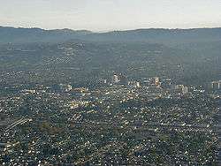
Cityscape
In general, San Mateo's downtown core and neighborhoods east of El Camino Real are more populous and have a greater density than the neighborhoods to the west of El Camino Real, where there is a lower population density.
.jpg)
Downtown
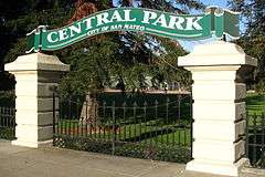
San Mateo has one of the larger, well developed, more prominent suburban downtowns in the San Francisco Bay Area. It is located roughly between Tilton and 9th Avenues and Delaware Street and El Camino Real[37] The downtown core contains over 800 shops and restaurants, many of them in historic buildings from the late 19th and early 20th centuries.[38] The non-profit Downtown San Mateo Association (DSMA) works on behalf of downtown businesses to promote them and improve the downtown area.[39] A historically influential area for the Japanese-American community, the downtown is home to many Japanese restaurants and shops. A large, modern 12-screen movie theatre complex gives the downtown a major entertainment option. Central Park is considered to be San Mateo's signature park with tennis courts, picnic areas, playground, a baseball field, a recreation center, a miniature train, and a Japanese Tea Garden.[40] San Mateo Caltrain station is situated downtown. The downtown also contains many large and small multi-story office buildings, apartments, government buildings and Mills Medical Center, making the area a busy employment center day and night.
.jpg) Downtown San Mateo businesses along 4th (2018)
Downtown San Mateo businesses along 4th (2018).jpg) "Main Street" alley, downtown San Mateo (2006)
"Main Street" alley, downtown San Mateo (2006).jpg) Hillsdale Shopping Center (2015)
Hillsdale Shopping Center (2015) Townhome development at Bay Meadows (2018)
Hillsdale
Hillsdale Shopping Center is a mall in San Mateo County, with over 100 stores in the mall itself, surrounded by many big box stores. The city of San Mateo has approved the construction of Cinépolis (luxury movie theater) and a Pinstripes bowling alley off El Camino Real. Sears is no longer in business and has been vacated for new businesses to occupy this space. Hillsdale Caltrain station is across El Camino Real.
Bay Meadows
Bay Meadows Racetrack was a former horse racing track near Hillsdale Mall, which closed down in 2008.[41] It is being redeveloped into a large mixed-use development which will include hundreds of new residential units, office space, retail space and acres of parks including a town square.[42] It started construction in 2013 and was completed in 2017.[43] It is a significant amount of new construction given the limited space available for development in the city and the peninsula.
Economy
.jpg)
The economy of San Mateo would best be considered very diverse with jobs in the technology, health care, financial services, government, and retail trade fields being among the most numerous. Companies based in San Mateo include Franklin Templeton Investments, Roblox Corporation, Fisher Investments, SolarCity, Solstice, Sony Interactive Entertainment, Marketo, GoPro, and NetSuite.
According to the City's 2018 Comprehensive Annual Financial Report, the top employers in the city are:[44]
| # | Employer | # of Employees |
|---|---|---|
| 1 | County of San Mateo Medical Center | 1,425 |
| 2 | San Mateo-Foster City Unified | 1,191 |
| 3 | Sony Interactive Entertainment | 1,168 |
| 4 | Franklin Templeton Investor | 1,055 |
| 5 | San Mateo Union High School District | 1,026 |
| 6 | San Mateo County Behavioral Health | 650 |
| 7 | Net Suite Inc | 600 |
| 8 | City of San Mateo | 547 |
| 9 | Fisher Investments | 423 |
| 10 | Marketo Inc | 410 |
Since 1990, San Mateo has had a voter-approved ordinance limiting the height of new development to 55 feet. The San Mateo housing market is one of the most expensive in the country. In February 2018, the median San Mateo home was valued at $1,463,900,[45] and the median rent was ninth in the entire nation at $2,242 per month.[46]
Education

Residents are zoned for schools in the San Mateo Foster City School District and San Mateo Union High School District. Elementary schools comprise Preschool, K-5, Middle and Magnet schools. There is a private, PreK-8 school: Saint Matthew's Episcopal Day School There are three public high schools: San Mateo, Aragon, and Hillsdale. There are also three private high schools: one all-male Catholic high school, Junípero Serra, one all-female Catholic high school, Notre Dame, and the Nueva Upper School. There is the Carey School.
The city is home to the College of San Mateo, a community college. The campus of over 10,000 students is located on 153 acres in the western foothills of the city which offer a panoramic view of the San Francisco Bay.[47] Other universities in the area include Notre Dame de Namur University, a private Catholic university of 2,000 students in neighboring Belmont[48] and Stanford University located about 12 miles to the south.
The San Mateo Union High School District also hosts an adult school behind the campus of San Mateo High School.[49]
Public libraries
 |
Selected locations in San Mateo
1 2 3 4 5 6 7 8 9 |
The City of San Mateo operates three libraries within the city. The Main Library, the Hillsdale Library, and the Marina Library are all part of the Peninsula Library System.[50] The Main Library located near Central Park in downtown opened in 2006 after residents passed a $30 million bond measure. Upon opening, the three-story, 93,000-square-foot building earned numerous design awards and was LEED-certified NC Gold. Floor-to-ceiling windows provide abundant natural light. The technologically advanced building is modeled after a retail bookstore.[51]
Parks and recreation
San Mateo maintains more than 15 parks throughout the city.
Central Park is considered to be the main one and hosts many community park functions that serve downtown residents. It has a Japanese tea garden, a rose garden, and a mini train.[52] Beresford Park is another large park that offers bocce ball and a skate plaza. Martin Luther King Jr Park (37.574°N 122.325°W) and Joinville Park (37.568°N 122.293°W) offer swimming pools while Ryder Park boasts a water play structure. Parkside Aquatic Park located on Seal Slough (37.560°N 122.291°W) has beach swimming and volleyball. Many of these parks have picnic areas with grills, children's play areas, basketball and tennis courts, and baseball diamonds.[53]
Coyote Point Park is near the border with Burlingame and on the San Francisco Bay. It is a 670-acre regional county park known for its ideal location for windsurfing and sailing. It is also home to CuriOdyssey: a hands-on science museum and small native animal zoo.[54]
Transportation
Freeways
San Mateo is considered to be near the center of the San Francisco Bay Area about halfway between San Francisco and San Jose, the region's two largest cities. It is served by three major freeways including U.S. Route 101, Interstate 280, and State Route 92. State Route 92 east of San Mateo traverses the San Francisco Bay as the San Mateo-Hayward Bridge to the city of Hayward on its eastern shore.
Bicycling
San Mateo has a network of bikeways connecting major destinations in the city. In 2011, the city approved a Bicycle Master Plan to establish bicycling goals, identify gaps in the existing bikeways system, and create a prioritized list of infrastructure improvement projects.[55]
Public transportation
SamTrans provides local bus service within the city of San Mateo as well as the entire county of San Mateo.[56] AC Transit provides transbay bus service via the San Mateo Bridge to Alameda County.[57] Caltrain provides commuter rail service on the San Francisco Peninsula between San Francisco and San Jose. Caltrain operates three stations within the city of San Mateo with stations at Hillsdale (serving the mall and surrounding area), Hayward Park (near Highway 92), and San Mateo (in downtown San Mateo). There are 41 northbound and 41 southbound trains with a stop in the city each weekday and 18 trains in both directions on weekends. Extra southbound trains are run to accommodate passengers after San Francisco Giants games.[58] See public transportation in San Mateo County for more details.
Airports
San Mateo is located near three major airports including San Francisco International Airport seven miles to the north. Oakland International Airport and San Jose Mineta International Airport are also within a half an hour drive. San Carlos Airport is a general aviation airport located about six miles to the south.
Other services
Hospitals in San Mateo include San Mateo Medical Center, an acute care facility operated by County of San Mateo.[59] Cemeteries include Skylawn Memorial Park and St. John's Cemetery.
Prominent places
The San Mateo Performing Arts Center, located on the campus of San Mateo High School, is one of the largest theatres on the peninsula outside of San Francisco. The College of San Mateo is also located in San Mateo and is home to radio station KCSM. The city is also home to the Bridgepointe and Hillsdale shopping centers. Bay Meadows horse-racing track was torn down in 2008.
The Japanese Tea Garden and San Mateo Arboretum in Central Park, San Mateo, CA. Central Park are of interest. U.S. Route 101, Interstate 280, and State Route 92 pass through San Mateo. One of its sister cities is Toyonaka, Japan, which the Japanese Tea Garden at Central Park was created to commemorate.[60]
 Japanese Tea Garden in Central Park
 Mosaic mural designed by Louis Macouillard & constructed by Alfonso Pardiñas (1963)
 Horse racing at Bay Meadows (2008)
Public art is located all around the city. One of the more memorable works is the 1963, large, brightly colored mosaic mural designed by Louis Macouillard and constructed by Alfonso Pardiñas.[61][62] The mural is located in front of a mid-century modern bank at 300 S. El Camino Real and tells the story of A. P. Giannini, the founder of Bank of Italy (United States).[61][62]
The College of San Mateo hosts a year-round Saturday morning farmers' market for visitors and San Mateo residents alike, at 1700 W Hillsdale Blvd. The market is operated by the Pacific Coast Farmers' Market Association and has over 100 farmers, hot food vendors, and artisans from the San Francisco Bay Area.[63]
Media
- San Mateo Daily Journal – Newspaper
- San Mateo County Times – Newspaper
- KCSM (FM)
- KPJK
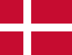
Sister cities
San Mateo has two sister cities, as designated by the Sister Cities International, Inc.:[64]

Notable people
- Michael Allen (born 1959), professional golfer
- Jane Baker, first female Mayor of San Mateo, city councilwoman from 1973 to 1993[67]
- Lina Basquette, actress
- David Binn (born 1972), 18-season NFL player
- Tom Brady (born 1977), legendary NFL quarterback who played 20 seasons with the New England Patriots. 6-time Super Bowl champion quarterback, 4-time Super Bowl MVP, three-time NFL Most Valuable Player, 14-time NFL Pro Bowl nominee; Currently plays for the Tampa Bay Buccaneers, Born in San Mateo[68]
- Doug Caine, psychologist, addiction treatment innovator, TV personality
- Catherine Chalmers, artist, photographer
- James P. Connolly, actor and radio/TV host
- Joseph Eichler, real estate developer, known for affordable mid-century modern homes
- Kenneth Fisher, Forbes columnist, financial author, money manager[69]
- Amadeo Giannini, founder of Bank of Italy, moved to San Mateo in 1906.[70]
- Merv Griffin (1925–2007), television personality, creator of Jeopardy! and Wheel of Fortune
- Greg Gutfeld, author, TV personality
- Dennis Haysbert, actor, known for Major League, Heat, 24, The Unit, and as spokesman for Allstate Insurance[71]
- Ann Kiyomura, tennis player, Wimbledon doubles champion
- James Lanza, Sicilian-born mobster, boss of the San Francisco crime family
- J. Kenji López-Alt, American chef, food writer, author of The Food Lab.
- Lee Mallory, poet, editor, retired professor
- John Matteson, Pulitzer Prize-winning biographer.
- Auston Matthews, Professional hockey player for the Toronto Maple Leafs.
- Sean Payton, head coach of the New Orleans Saints.
- Jeff Serr, radio personality, voice actor
- Kendal Smith, NFL player
- Jack Stauffacher, book designer, graphic designer, printmaker
- Lynn Swann (born 1952), Serra student, former NFL wide receiver for the Pittsburgh Steelers, 4-time Super Bowl champion, 1976 Super Bowl MVP, athletic director University of Southern California; was host of To Tell The Truth
- Michael Trucco, actor
- Cal Tjader, jazz musician
- John Wetteland, MLB pitcher.
See also
References
- "California Cities by Incorporation Date" (Word). California Association of Local Agency Formation Commissions. Retrieved January 13, 2017.
- "Meet the Council". San Mateo, CA. Retrieved June 4, 2020.
- "Office of the City Manager". San Mateo, CA. Retrieved April 11, 2018.
- "2016 U.S. Gazetteer Files". United States Census Bureau. Retrieved June 28, 2017.
- "San Mateo". Geographic Names Information System. United States Geological Survey. Retrieved December 3, 2014.
- "San Mateo (city) QuickFacts". United States Census Bureau. Archived from the original on February 24, 2015. Retrieved February 23, 2015.
- "Population and Housing Unit Estimates". Retrieved May 21, 2020.
- "ZIP Code(tm) Lookup". United States Postal Service. Retrieved December 3, 2014.
- Postel, Mitchell P. (1994). San Mateo :a centennial history (1st ed.). San Francisco, Calif.: Scottwall Associates, Publishers. p. 13. ISBN 978-0-942087-08-6.
- Waterman L. Ormsby, Lyle H. Wright, Josephine M. Bynum, The Butterfield Overland Mail: Only Through Passenger on the First Westbound Stage, Henry E. Huntington Library and Art Gallery, 2007. pp. 92–93
- architecture + history llc (October 5, 2012). Historical Resource Evaluation Report: 25 – 31 9th Street, San Mateo, CA (Report). City of San Mateo Community Development Department. Retrieved March 23, 2015.
- Fredricks, Darold (February 25, 2008). "San Mateo's Peninsula Hotel". San Mateo Daily Journal. Archived from the original on April 2, 2015. Retrieved March 22, 2015.
- Myrow, Rachel (January 27, 2015). "San Mateo Rides Tech Boom But Keeps Small-Town Feel". KQED News. Retrieved August 4, 2015.
- Widell, Cherilyn (July 30, 1992). "National Register of Historic Places — Registration Form: de Sabla, Eugene J., Jr., Teahouse and Tea Garden". United States Department of the Interior, National Park Service. Retrieved March 22, 2015.
- Levy, Joan (November 13, 2006). "Only San Mateo honored these veterans". San Mateo Daily Journal. Archived from the original on January 4, 2017. Retrieved January 4, 2017.
- Silverfarb, Bill (May 26, 2012). "A letter home". San Mateo Daily Journal. Retrieved January 4, 2017.
- "The History of Our Adoption of the Screaming Eagles". City of San Mateo. 2017. Retrieved January 4, 2017.
- "Joseph Gregory Artavia". The Virtual Wall. September 12, 2015. Retrieved January 4, 2017.
- Silverfarb, Bill (May 15, 2012). "Operation Eagle Visit". San Mateo Daily Journal. Archived from the original on January 4, 2017. Retrieved January 4, 2017.
- Gross, Jane (June 29, 1988). "San Mateo Journal; Suburb Is Reliving Two 60's Love Stories". The New York Times. Retrieved January 4, 2017.
- "US Gazetteer files: 2010, 2000, and 1990". United States Census Bureau. February 12, 2011. Retrieved April 23, 2011.
- Brown, 1975
- Pfeifle, 1980
- Gilliam, Harold (2002). "The Four Seasons: Summer". Weather of the San Francisco Bay Region (2nd ed.). Berkeley: University of California Press. pp. 40–43. ISBN 978-0-520-22989-1. Retrieved March 23, 2015.
- "Bay Area Climatology: Peninsula Subregion". Bay Area Air Quality Management District. October 4, 2010. Retrieved March 23, 2015.
- Note that the climate chart below uses data from The Weather Channel <http://www.weather.com/weather/wxclimatology/monthly/graph/USCA1005>
- Western Regional Climate Center website <http://wrcc.dri.edu/>
- http://www.weather.com/weather/wxclimatology/monthly/graph/USCA1005
- "Census of Population and Housing". Census.gov. Retrieved June 4, 2015.
- "2010 Census Interactive Population Search: CA - San Mateo city". U.S. Census Bureau. Archived from the original on July 15, 2014. Retrieved July 12, 2014.
- "2007-2011 American Community Survey 5-Year Estimates". United States Census Bureau. 2011. Archived from the original on February 12, 2020. Retrieved April 8, 2020.
- "Demographic Profile Bay Area Census".
- "San Mateo City Charter and Municipal Code (San Mateo, California)". qcode.us. Retrieved January 29, 2019.
- "Statewide Database". UC Regents. Archived from the original on February 1, 2015. Retrieved November 18, 2014.
- "California's 14th Congressional District - Representatives & District Map". Civic Impulse, LLC. Retrieved March 12, 2013.
- "CA Secretary of State – Report of Registration – February 10, 2019" (PDF). ca.gov. Retrieved March 12, 2019.
- http://www.zipmat.net/
- "City of San Mateo". Archived from the original on June 22, 2013. Retrieved August 1, 2016.
- "DowntownSanMateo.org | About". Retrieved January 29, 2019.
- "City of San Mateo Parks". Retrieved August 1, 2016.
- Bay Meadows closes its doors | abc7news.com. Abclocal.go.com (2008-05-11). Retrieved on 2013-07-21.
- Simmers, Tim. (1934-11-03) Bay Meadows nears finish. Urban Habitat. Retrieved on 2013-07-21.
- "Home". Retrieved August 1, 2016.
- https://www.cityofsanmateo.org/DocumentCenter/View/66839 City of San Mateo CAFR
- Zillow, San Mateo Home Prices & Values
- https://twitter.com/foxjust/status/966375495733579776
- "College of San Mateo". Retrieved August 1, 2016.
- "Notre Dame de Namur University - Opening Doors. Engaging Minds". Retrieved August 1, 2016.
- "San Mateo Adult School". Archived from the original on August 14, 2016. Retrieved August 1, 2016.
- "Library Locations & Hours." City of San Mateo. Retrieved on October 6, 2009.
- Architecture Record | McGraw-Hill Construction Archived March 20, 2013, at the Wayback Machine. Archrecord.construction.com (2011-10-05). Retrieved on 2013-07-21.
- "San Mateo, CA - Official Website". Retrieved August 1, 2016.
- "San Mateo, CA - Official Website". Retrieved August 1, 2016.
- http://www.co.sanmateo.ca.us/
- "Bicycling Master Plan 2011 | San Mateo, CA - Official Website". www.cityofsanmateo.org. Retrieved January 29, 2019.
- "511 SF BAY". Archived from the original on February 21, 2016. Retrieved August 1, 2016.
- "511 SF BAY". Archived from the original on March 4, 2016. Retrieved August 1, 2016.
- 2017 Giants Service. Caltrain.com (2017-04-04). Retrieved on 2017-05-24.
- "San Mateo Medical Center - San Mateo County Health System". Retrieved August 1, 2016.
- Visiting Eden: The Public Gardens of Northern California, photographs by Melba Levick, text by Joan Chatfield-Taylor. Chronicle Books, 1993, ISBN 0-8118-0107-1
- Weinstein, Dave (September 12, 2014). "Design Destination: Macouillard's Mosaic". Eichler Network. Retrieved December 6, 2017.
- "California Bucket List". Los Angeles Times. ISSN 0458-3035. Retrieved December 6, 2017.
- "Home Page | PCFMA".
- Sister Cities information obtained from the Sister Cities International, Inc. (SCI) Archived February 25, 2016, at the Wayback Machine. Retrieved on February 18, 2016.
- San Mateo City Council resolution to adopt Varde as a sister city. November 17, 1969. Retrieved on February 18, 2016.
- "San Mateo and Toyonaka Celebrate 50 Years" in the 2013 Late Summer Edition Archived June 30, 2014, at the Wayback Machine of the San Mateo City Newsletter. Retrieved on February 18, 2016.
- Orenstein, Natalie (July 8, 2011). "Jane Baker, San Mateo's first female mayor, dies". San Francisco Chronicle. Retrieved July 8, 2011.
- Cian Fahey. "What another Super Bowl ring does to Tom Brady's legacy". Irish Central. Retrieved January 28, 2012.
- J. William Carpenter. "Ken Fisher's Success Story: Net Worth, Education & Top Quotes". Investopedia. Retrieved March 5, 2016.
- "Bank of America founder Amadeo Giannini's San Mateo home". SFGate. Retrieved December 6, 2017.
- "Dennis Haysbert". Retrieved August 1, 2016.
Further reading
- Alexander, Philip W; Hamm, Charles P (1916). History of San Mateo County from the earliest times : with a description of its resources and advantages : and the biographies of its representative men. Burlingame: Press of Burlingame Publishing. OCLC 8749374. Retrieved March 25, 2015.
- Brown, Alan K. (1975). Place Names of San Mateo County. San Mateo, Ca.: San Mateo County Historical Association. OCLC 2584621.
- Cloud, Roy Walter (1928). History of San Mateo County, California. Chicago: S.J. Clarke. OCLC 77013.
- History of San Mateo County, California. San Francisco: B.F. Alley. 1883. OCLC 16824711. Retrieved March 23, 2015.
- Hynding, Alan (1982). From Frontier to Suburb: The Story of the San Mateo Peninsula. Star Publishing. ISBN 9780898630558. OCLC 8892429.
- Mission Dolores, San Francisco, Register of Baptisms (1776–1870) and Register of Deaths (1776–1876)
- Postel, Mitchell P. (1994). San Mateo: A Centennial History. San Francisco: Scottwall Associates. ISBN 978-0-942087-08-6. OCLC 31092074.
- Ringler, Donald P (1975). San Mateo, U.S.A. : the golden years; an early background and sixty years of the city of San Mateo's history from its beginning at the Polhemus Plat in 1862 up through World War I. San Mateo: San Mateo Bicentennial Committee. OCLC 19844093.
- Stanger, Frank Merriman (1963). South from San Francisco; San Mateo County, California, its history and heritage. San Mateo: San Mateo County Historical Association. OCLC 2694047.
- U.S. Bureau of Land Management, FN 254-21 (1853)
- Zompolis, Gregory N (2004). Images of America: San Mateo. Charleston, SC: Arcadia. ISBN 9780738529561. OCLC 59007999.
External links
Municipalities and communities of San Mateo County, California, United States | ||
|---|---|---|
| Cities and towns | 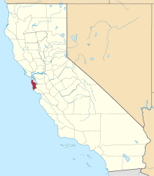 San Mateo County map | |
| CDPs | ||
| Unincorporated communities | ||
| Ghost towns | ||
| Bodies of water |
|  |
|---|---|---|
| Counties | ||
| Major cities | ||
| Cities and towns 100k–250k | ||
| Cities and towns 50k–99k | ||
| Cities and towns 25k–50k | ||
| Cities and towns 10k–25k |
| |
| Sub-regions | ||

| Authority control |
|
|---|