Woodside, California
Woodside is a small incorporated town in San Mateo County, California, United States, on the San Francisco Peninsula. It has a council–manager system of government. The population of the town was 5,287 at the 2010 census.[7]
Town of Woodside | |
|---|---|
Town in California | |
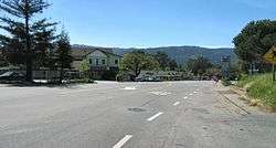 Downtown Woodside business district on Woodside Road | |
 Location in San Mateo County and the state of California | |
 Town of Woodside Location in the United States | |
| Coordinates: 37°25′15″N 122°15′35″W | |
| Country | |
| State | |
| County | San Mateo |
| Incorporated | November 16, 1956[1] |
| Government | |
| • Type | Town Council |
| Area | |
| • Total | 11.73 sq mi (30.38 km2) |
| • Land | 11.73 sq mi (30.38 km2) |
| • Water | 0.00 sq mi (0.00 km2) 0% |
| Elevation | 387 ft (118 m) |
| Population | |
| • Total | 5,287 |
| • Estimate (2018)[5] | 5,510 |
| • Density | 473.19/sq mi (182.70/km2) |
| Time zone | UTC−8 (Pacific) |
| • Summer (DST) | UTC−7 (PDT) |
| ZIP codes[6] | 94061–94062 |
| Area code | 650 |
| FIPS code | 06-86440 |
| GNIS feature IDs | 1660202, 2413509 |
| Website | www |
Woodside is home to many horses and is among the wealthiest communities in the United States. The median household income in the town is $212,917, and the median family income is $246,042.[8]
History and culture
The Woodside area was originally home to natives belonging to the Ohlone tribe. In 1769, led by Gaspar de Portolá, Spanish explorers searching for San Francisco Bay camped at a site near Woodside.
Woodside is located on the Rancho Cañada de Raymundo Mexican Land grant. Woodside is said to be the oldest English-speaking settlement in the southern part of the San Francisco Peninsula. The first English-speaking settlers arrived in the early 19th century to log the rich stands of redwoods. Charles Brown constructed the first sawmill in Woodside on his Mountain Home Ranch around 1838. Brown's adobe house, built in 1839, still stands today.[9] By mid-century, the Woodside area had a dozen mills producing building materials for a booming San Francisco.
In 1849, during the California Gold Rush, 20-year-old Mathias Alfred Parkhurst purchased 127 acres (0.5 km2) of timberland and named it “Woodside"; of course, this name was kept. By the late 19th century, Woodside was home to country estates. The Sequoia Redwood trees in Woodside are currently 3rd generation growth. The first generation of the Redwood trees were used to build San Francisco original homes. After the 1906 San Francisco earthquake, the loggers returned to Woodside to cut the second growth of redwood so they could be used for the rebuilding of San Francisco.
In 1909, the Family, a private club, set up camp facilities and rustic buildings in Woodside at the Family Farm, a rural retreat used by club members for recreation. Gatherings at the Family Farm include an annual Farm Play, written and performed by members. In 1912, the Family pooled funds to build Our Lady of the Wayside Church in Portola Valley, designed by 19-year-old Timothy L. Pflueger, his first commission.[10] The historic building was repaired at a cost of US$600,000 after the 1989 Loma Prieta earthquake.[11]
Woodside was incorporated in 1956 to prevent urbanization, and it still retains a rural residential character, though it is a short commute to Silicon Valley.
Present
Today, Woodside is among the wealthiest small towns in the United States.[8]
The intentionally small business district includes: a few restaurants; a grocery store; a saloon; a hardware and horse tack store; a home and garden store; an Aveda hair salon; a cleaner; and a post office. Outside of the business district are the Stillheart Institute educational event center, Skywood Trading Post and the Mountain Terrace event center.
Town restaurants include the Michelin starred Village Pub, Buck's of Woodside restaurant, known among Silicon Valley entrepreneurs as the location where many VC investment deals have been signed, and the Firehouse Bistro.
Horses are part of the local culture. Numerous residents keep horses, and the town government maintains a network of horse trails. Some resident's homes are even considered farms. The town is also popular among local cyclists and draws them in large numbers on weekends. The most popular road cycling routes include Old La Honda Road, King's Mountain Road, Cañada Road, Southgate Drive, Skyline Boulevard and Highway 84. The Tour of California bicycle race includes several roads along and adjacent to CA-84 and Skyline Boulevard.
Woodside is home to a number of open space preserves, including the Purisima Open Space (part of the Midpeninsula Regional Open Space), where both horseback riding and bicycling are allowed. For mountain biking, the famous Skeggs Point is located in Woodside along Skyline Boulevard.
The Woodside Fire District is a special district serving Woodside, Portola Valley and unincorporated areas including Ladera, Los Trancos Woods, Vista Verde, Emerald Lake, Menlo Park (Unincorporated) and the Skyline/State Route 35 area.
Dr. Carl Djerassi founded an artists' colony in the community in memory of his late daughter Pamela.[12] The Djerassi Artists Residency is one of several Bay Area programs that houses artists. It is located adjacent to the campus of Stanford University, east of the town. Other Bay Area programs include Montalvo Arts Center in Saratoga and Headlands Center for the Arts in Marin.
Geography and climate
Woodside is located at 37°25′15″N 122°15′35″W (37.420704, −122.259777).[13]
Woodside is located on the San Francisco Peninsula, midway between San Jose and San Francisco, just north of Silicon Valley, in San Mateo County. The infamous San Andreas fault runs through town. This fault is a major source of earthquake activity in California, including the 1906 San Francisco earthquake.
Much of Woodside is wooded, with redwoods and Douglas fir dominating in the western hills and more oaks and eucalyptus in the lower areas. San Francisco Bay lies to the east, while Pacific Ocean beaches lie to the west. The Santa Cruz mountains separate Woodside from the ocean and extend down to Monterey Bay about forty miles south.
According to the United States Census Bureau, the town has a total area of 11.7 square miles (30 km2), all land.
The nearest cities and towns are Redwood City, Menlo Park, Portola Valley, Atherton, San Carlos, Belmont, and Palo Alto.
Climate
As is true of most of the California coastal areas, weather in Woodside is usually mild during most of the year. Summers are dry and can be hot; winter temperatures rarely dip much below freezing. Average January temperatures are a maximum of 60 °F (16 °C) and a minimum of 36 °F (2 °C). Average July temperatures are a maximum of 88 °F (31 °C) and a minimum of 51 °F (11 °C).[14] Snowfall is extremely rare except in the nearby Santa Cruz Mountains, where several inches falls every several years. Annual precipitation averages 30.9 inches (785.4 millimeters) and falls on an average of 61 days annually.[15]
The record maximum temperature was 114 °F (46 °C) on July 22, 2006, and the record minimum temperature was 17 °F (−8 °C) on February 6, 1989. Temperatures reach 90 °F (32 °C) or higher on an average of 48.4 days annually. Temperatures drop to freezing on an average of 10.0 days annually. The maximum rainfall in one year was 59.86 inches (1,520 mm) in 1983. The maximum rainfall in one month was 20.50 inches (521 mm) in December 2002 and the maximum in 24 hours was 4.64 inches (118 mm) on December 1, 2002. On February 5, 1976, 3.0 inches of snow fell at the fire station.[16]
Hills and mountains between Woodside and the Pacific coast make fog much less prevalent than in nearby San Francisco. As well, during the summer, Woodside's climate is remarkably hotter than that of San Francisco.
Parks and environmental features
Woodside has a variety of habitat types including California oak woodland and riparian zones. There is considerable biodiversity present, Woodside being within the California Floristic Province. Notable species present include the rare and endangered species Acanthomintha duttonii, the San Mateo Thornmint. It is also home to Huddart County Park, which is accessible by authorized motor vehicles, pedestrians, and horses on Kings Mountain Road. The other vehicle accessible entrance is off of Kings Mountain Road, approximately halfway up the road from the point at which it starts to climb a narrow hill in the Coastal Range of California. This is accessible to the public, which can drive down Toyon road until further driving of unauthorized vehicles is unlawful, which is just after Sequoia Campground. Also, other than the main entrance, several entrances are accessible to pedestrians and horses only and are located along Kings Mountain Road.
While Huddart County Park is probably the most well-known park in Woodside, Wunderlich Park is extremely popular with both hiking and horse enthusiast. The trails in this park are shared by those on foot and on horse and span almost 1000 acres. Unfortunately, for cyclists they are not allowed on the trails in this park.
Demographics
| Historical population | |||
|---|---|---|---|
| Census | Pop. | %± | |
| 1960 | 3,592 | — | |
| 1970 | 4,734 | 31.8% | |
| 1980 | 5,291 | 11.8% | |
| 1990 | 5,035 | −4.8% | |
| 2000 | 5,352 | 6.3% | |
| 2010 | 5,287 | −1.2% | |
| Est. 2018 | 5,510 | [5] | 4.2% |
| U.S. Decennial Census[17] | |||
2010
At the 2010 census Woodside had a population of 5,287. The population density was 450.6 people per square mile (174.0/km2). The racial makeup of Woodside was 4,717 (89.2%) White, 23 (0.4%) African American, 4 (0.1%) Native American, 332 (6.3%) Asian, 4 (0.1%) Pacific Islander, 63 (1.2%) from other races, and 144 (2.7%) from two or more races. Hispanic or Latino of any race were 243 people (4.6%).[18]
The whole population lived in households, no one lived in non-institutionalized group quarters and no one was institutionalized.
There were 1,977 households, 643 (32.5%) had children under the age of 18 living in them, 1,313 (66.4%) were opposite-sex married couples living together, 124 (6.3%) had a female householder with no husband present, 50 (2.5%) had a male householder with no wife present. There were 54 (2.7%) unmarried opposite-sex partnerships, and 19 (1.0%) same-sex married couples or partnerships. 383 households (19.4%) were one person and 171 (8.6%) had someone living alone who was 65 or older. The average household size was 2.67. There were 1,487 families (75.2% of households); the average family size was 3.01.
The age distribution was 1,243 people (23.5%) under the age of 18, 244 people (4.6%) aged 18 to 24, 823 people (15.6%) aged 25 to 44, 1,909 people (36.1%) aged 45 to 64, and 1,068 people (20.2%) who were 65 or older. The median age was 48.8 years. For every 100 females, there were 95.4 males. For every 100 females age 18 and over, there were 94.7 males.
There were 2,157 housing units at an average density of 183.9 per square mile, of the occupied units 1,721 (87.1%) were owner-occupied and 256 (12.9%) were rented. The homeowner vacancy rate was 0.9%; the rental vacancy rate was 3.7%. 4,749 people (89.8% of the population) lived in owner-occupied housing units and 538 people (10.2%) lived in rental housing units.
2000
At the 2000 census there were 5,352 people in 1,949 households, including 1,516 families, in the town. The population density was 455.1 people per square mile (175.7/km2). There were 2,030 housing units at an average density of 172.6 per square mile (66.6/km2).[19] There were 1,949 households, of which 31.6% had children under the age of 18. 68.8% were married couples living together, 5.8% had a female householder with no husband present, and 22.2% were non-families. 15.9% of households were one person and 6.2% were one person aged 65 or older. The average household size was 2.74 and the average family size was 2.98.
The age distribution was 23.4% under the age of 18, 3.6% from 18 to 24, 24.1% from 25 to 44, 32.9% from 45 to 64, and 16.0% 65 or older. The median age was 44 years. For every 100 females, there were 98.4 males. For every 100 females age 18 and over, there were 96.1 males.
The median household income in the town was $212,917,[8] and the median family income was $246,042.[8] The per capita income for the town was $117,760.[8] About 1.6% of families and 2.8% of the population were below the poverty line, including 1.4% of those under age 18 and 4.8% of those age 65 or over.
Economy
Argonaut Games formerly had its U.S. headquarters in Woodside.[20]
Politics
According to the California Secretary of State, as of October 24, 2016, Woodside has 4082 registered voters. Of those, 1606 (39.3%) are registered Democrats, 1,256 (30.8%) are registered Republicans, and 1052 (25.9%) have declined to state a political party.[21]
In the California State Legislature, Woodside is in the 13th Senate District, represented by Democrat Jerry Hill, and in the 24th Assembly District, represented by Democrat Marc Berman.[22]
Federally, Woodside is in California's 14th congressional district, represented by Democrat Jackie Speier.[23]
Schools
The Woodside Elementary School District operates public elementary and middle schools. The Sequoia Union High School District operates Woodside High School.
Funding for public schools in Woodside are supplemented by grants from private foundations set up for that purpose and funded by local residents.[24]
Film and television
The house in the Robin Williams movie Bicentennial Man is in Woodside. Dynasty was filmed at the Filoli Estate (not the interior of the mansion, but the exterior), as were the films The Wedding Planner, The Game, Lolita, George of the Jungle, Heaven Can Wait, and Harold and Maude. The musical Rent also has a scene filmed inside the Filoli Estate.
Notable people
Several well-known people who live or have lived here, include:


.jpg)
- Joan Baez, folk singer
- Frances Baldwin, artist[25]
- Nolan Bushnell, founder of Atari and Chuck E. Cheese's Pizza-Time Theater
- Scott Cook, co-founder of Intuit, Inc.[26]
- John Doerr, venture capitalist
- Masayoshi Son, founder and CEO of Softbank[27]
- Carl Djerassi, novelist and member of team that developed the birth control pill;
- Julian Edelman, football player, attended Woodside High School
- Larry Ellison, CEO of Oracle Corporation, who spent nine years building an architecturally authentic, $200+ million Japanese feudal castle and man-made lake in Woodside;[28]
- Kenneth Fisher, founder of Fisher Investments, Forbes columnist, author, and local historian
- James Folger, coffee magnate
- Kazuo Hirai, CEO of Sony Corporation
- Steve Jobs, co-founder of Apple Inc. owned the Jackling House in Woodside, but had it demolished and was in the process of replacing it with a modern home on the same parcel before his death.
- Margaret Keane, artist who produced popular paintings of "big eye" waifs, and Walter Keane, her husband, who falsely claimed he had painted them.[29]
- Koko, the gorilla who was taught in American Sign Language
- Joe Lonsdale, founder of Palantir Technologies
- Mike Markkula, second CEO of Apple Inc.
- Willie McCovey, nicknamed "Mac", "Big Mac", and "Stretch". He played nineteen seasons for the San Francisco Giants. McCovey Cove at AT&T Park, and Willie McCovey Field at Woodside Elementary School are named after him.
- Gordon E. Moore, co-founder of Intel and originator of Moore's Law
- Michelle Pfeiffer, actress, and her husband David E. Kelley, producer
- Prince Vasili Alexandrovich of Russia, Russian royalty, nephew of Tsar Nicholas II
- Charles R. Schwab, American investor and founder of Charles Schwab Corporation
- Thomas Siebel, founder of Siebel Systems
- Jeffrey Skoll, Canadian internet entrepreneur
- Shirley Temple Black, child movie star
- Zack Test, rugby union player
- John Thompson, CEO of Symantec
- Bill Walsh, former San Francisco 49ers head coach and Pro Football Hall of Fame, who died on July 30, 2007.
- Ricky Watters, Former NFL running back
- Nick Woodman, founder and CEO of GoPro
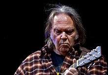
- Neil Young, rock musician and songwriter, who owns a 1,500 acres (6.1 km2) ranch and recording studio
Points of interest
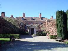 Filoli Estate
 Woodside Public Library
 The Woodside Store, a local park includes a preserved historic hardware store.
 Folger Estate Stable Historic District, within Wunderlich Park.
The city is served by the Woodside Public Library of the San Mateo County Libraries, a member of the Peninsula Library System.
See also
- Skeggs Point, California
References
- "California Cities by Incorporation Date". California Association of Local Agency Formation Commissions. Archived from the original (Word) on November 3, 2014. Retrieved August 25, 2014.
- "2016 U.S. Gazetteer Files". United States Census Bureau. Retrieved June 28, 2017.
- "Woodside". Geographic Names Information System. United States Geological Survey. Retrieved December 3, 2014.
- "Woodside (town) QuickFacts". United States Census Bureau. Archived from the original on May 18, 2012. Retrieved March 12, 2015.
- "Population and Housing Unit Estimates". Retrieved September 16, 2019.
- "ZIP Code(tm) Lookup". United States Postal Service. Retrieved December 3, 2014.
- "Profile of General Population and Housing Characteristics: 2010 Demographic Profile Data (DP-1): Woodside town, California". United States Census Bureau. Retrieved April 5, 2012.
- "Woodside, California". Median Income in 2013. United States Census Bureau. 2013. Retrieved July 2, 2015.
- "Eucalyptus trees fall, Brown Adobe stays put at Woodside's former Schroll estate". The Almanac News. July 6, 2005. Retrieved August 2, 2017.
- Poletti, Therese (2008). Art Deco San Francisco: The Architecture of Timothy Pflueger. Princeton Architectural Press. ISBN 978-1-56898-756-9.
- St. Denis Parish. History
- "Djerassi artists' retreat hosts rare open house". East Bay Times. July 28, 2007. Retrieved August 2, 2017.
- "US Gazetteer files: 2010, 2000, and 1990". United States Census Bureau. February 12, 2011. Retrieved April 23, 2011.
- worldclimate.com
- citytowninfo.com
- wrcc.dri.edu
- "Census of Population and Housing". Census.gov. Retrieved June 4, 2015.
- "2010 Census Interactive Population Search: CA - Woodside town". U.S. Census Bureau. Archived from the original on July 15, 2014. Retrieved July 12, 2014.
- "U.S. Census website". United States Census Bureau. Retrieved January 31, 2008.
- "Company Summary" (Archive). Argonaut Games. October 29, 1996. Retrieved on May 21, 2016. "Argonaut USA Rich Seidner - Head of US Operations 210 Grandview Drive, Woodside, California, 94062, USA"
- "Statewide Database". UC Regents. Archived from the original on February 1, 2015. Retrieved November 29, 2014.
- "California's 14th Congressional District - Representatives & District Map". Civic Impulse, LLC. Retrieved March 13, 2013.
- George Packer (May 27, 2013). "Change the World Silicon Valley transfers its slogans—and its money—to the realm of politics". The New Yorker. Retrieved July 30, 2015.
In wealthy districts, the public schools have essentially been privatized; they insulate themselves from shortfalls in state funding with money raised by foundations they have set up for themselves.
- "Frances Baldwin". SFGate. Hearst Communications. Retrieved December 25, 2015.
- "Scott Cook". Forbes. Retrieved November 4, 2014.
- "Masayoshi Son". Forbes. Retrieved July 7, 2015.
- Woollard, Deidre (March 27, 2008). "Larry Ellison's $3 Million Tax Rebate". Luxist.com. Retrieved October 1, 2012.
- Nelson, Cletus. Citizen Keane: The Big Lies Behind the Big Eyes. Feral House.
External links
| Wikimedia Commons has media related to Woodside, California. |
- Official website

- Woodside Public Library – a branch of the San Mateo County Library
- Woodside Fire Protection District
Municipalities and communities of San Mateo County, California, United States | ||
|---|---|---|
| Cities and towns |  San Mateo County map | |
| CDPs | ||
| Unincorporated communities | ||
| Ghost towns | ||
| Bodies of water |
|  |
|---|---|---|
| Counties | ||
| Major cities | ||
| Cities and towns 100k–250k | ||
| Cities and towns 50k–99k | ||
| Cities and towns 25k–50k | ||
| Cities and towns 10k–25k |
| |
| Sub-regions | ||
| Authority control |
|
|---|