Benicia, California
Benicia (/bəˈniːʃə/ bə-NEE-shə; bə-NI-shə; Spanish pronunciation: [beˈnisja]) is a waterside city in Solano County, California, located in the North Bay region of the San Francisco Bay Area. It served as the state capital for nearly thirteen months from 1853 to 1854. The population was 26,997 at the 2010 census. The city is located along the north bank of the Carquinez Strait. Benicia is just east of Vallejo and across the strait from Martinez. Elizabeth Patterson has served as Mayor of Benicia since 2007.
City of Benicia | |
|---|---|
City | |
 California's third capitol at Benicia. The Senate chambers on first floor, and the Assembly chambers above. | |
| Motto(s): "It's better in Benicia!" | |
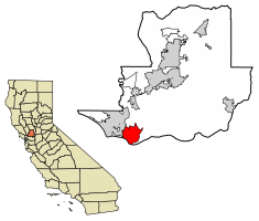 Location of Benicia in Solano County, California | |
 City of Benicia Location in the United States | |
| Coordinates: 38°3′48″N 122°9′22″W | |
| Country | |
| State | |
| County | Solano |
| Incorporated | March 27, 1850[1] |
| Government | |
| • Mayor | Elizabeth Patterson[2] |
| • State senator | Bill Dodd (D)[3] |
| • Assemblymember | Tim Grayson (D)[3] |
| • U. S. rep. | Mike Thompson (D)[4] |
| Area | |
| • Total | 15.72 sq mi (40.71 km2) |
| • Land | 12.93 sq mi (33.49 km2) |
| • Water | 2.79 sq mi (7.23 km2) 17.75% |
| Elevation | 26 ft (8 m) |
| Population | |
| • Total | 26,997 |
| • Estimate (2019)[8] | 28,240 |
| • Density | 2,179.13/sq mi (841.37/km2) |
| Time zone | UTC−8 (Pacific) |
| • Summer (DST) | UTC−7 (PDT) |
| ZIP code | 94510 |
| Area code | 707 |
| FIPS code | 06-05290 |
| GNIS feature IDs | 0277472, 2409833 |
| Website | www |
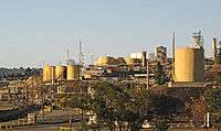
The town is divided into four areas: the East Side (east of First Street), the West Side (west of First Street), Southampton (north of Interstate 780), and the industrial park. Most of the town's older homes are on the east and west sides. Southampton contains primarily single-family housing developments and condominiums, most of which were built between 1970 and 2000. The East Side includes the Benicia Arsenal, a former United States Army armory, which was bought by the city and is now used for a variety of purposes, most notably as live-work spaces for artists. The Arsenal is home to several historic (ca. 1860) landmark buildings such as The Clocktower, the Camel Barn, and the Lieutenant's Quarters (currently known as Jefferson Street Mansion).[9] The industrial park lies to the northeast of the residential areas of the city, and includes the Valero oil refinery. The Benicia State Recreation Area is on the far west edge of the city.
The main retail area in Benicia is First Street, which attracts out-of-town antique and boutique shoppers and those seeking small-town, historic charm. In 1987 Benicia was selected to participate in the California Main Street Program.[10]
Connections to Benicia include Interstate 680 from Martinez to the south and Cordelia Junction (Fairfield) to the north, and Interstate 780, Columbus Parkway, and other local roads from Vallejo to the west. Amtrak also runs through the city north towards Sacramento, but the nearest train station lies in Martinez across the Carquinez Strait. Railroad tracks carrying Amtrak and Union Pacific Railroad lines cross the strait alongside the Benicia–Martinez Bridge.
History
The City of Benicia was founded on May 19, 1847, by Dr. Robert Semple,[11] Thomas O. Larkin, and Comandante General Mariano Guadalupe Vallejo, on land sold to them by General Vallejo in December 1846. It was named for the General's wife, Francisca Benicia Carillo de Vallejo. The General intended that the city be named "Francisca" after his wife, but this name was dropped when the former city of "Yerba Buena" changed its name to "San Francisco," so her second given name was used instead. In his memoirs, William Tecumseh Sherman contended that Benicia was "the best natural site for a commercial city" in the region.[12]It is said that in 1848 first word of gold found at Sutter's Mill was leaked at a Benicia Tavern thus starting the Gold Rush. Benicia became a way station on the way to the Sierras.[13]
Benicia was the third site selected to serve as the California state capital, and its newly constructed city hall was California's capitol from February 11, 1853, to February 25, 1854. Soon after the legislature was moved to the courthouse in Sacramento, which has remained the state capital ever since. The restored capitol is part of the Benicia Capitol State Historic Park, and is the only building remaining of the state's early capitols, which were in San Jose and Vallejo. Benicia was also the county seat of Solano County until 1858, when that was moved to Fairfield.
The original campus of Mills College was founded in Benicia in 1852 as the Young Ladies Seminary, and was the first women's college west of the Rocky Mountains. Before moving to Oakland in 1871, it was located on West I Street, just north of First Street.
On June 5, 1889, the legendary prize fight between James J. Corbett and Joe Choynski was held on a barge off the coast of Benicia. The match lasted 28 rounds, and is now commemorated by a plaque near Southampton Bay.
From 1860 to 1861, Benicia was indirectly involved in the Pony Express. When riders missed their connection with a steamer in Sacramento, they would continue on to Benicia and cross over to Martinez via the ferry.[14] One of the earliest companies in California, the Pacific Mail Steamship Company, established a major shipyard in Benicia in the 19th century. The prolific shipbuilder Matthew Turner formed the Matthew Turner Shipyard at Benicia in 1883. Benicia became an important wheat storage and shipping site. It was also the site of the United States Army's Benicia Arsenal.
In 1879, the Central Pacific Railroad rerouted the Sacramento-Oakland portion of its transcontinental line, establishing a major railroad ferry across the Carquinez Strait from Benicia to Port Costa. The world's largest ferry, the Solano, later joined by the even larger Contra Costa, carried entire trains across the Carquinez Strait from Benicia to Port Costa, from whence they continued on to the Oakland Pier.[15]
In 1901, the world's first long-distance powerline crossing over Carquinez Strait was built. After California's wheat output dropped in the early 20th century and especially after the Southern Pacific (which took over the operations of the Central Pacific) constructed a railroad bridge at Martinez in 1930 to replace the ferry crossing, Benicia declined until the economic boom of World War II, which doubled the population to about 7,000 residents.
A major fire on March 22, 1945, destroyed a half-block of businesses, including the nearly-century-old “old brewery”, and the Solano Hotel, with flames briefly threatening the old state capitol, now an historical landmark. A roof fire was quickly extinguished and the structure was not badly damaged. Losses were estimated at $125,000.[16]
Two developments in the early 1960s would completely change Benicia: The closing of the Benicia Arsenal in 1960–64, and the completion of the Benicia–Martinez Bridge in 1962. The closing of the Arsenal removed Benicia's traditional economic base, but allowed city leaders to create an industrial park on Arsenal land which eventually provided more revenue for the city than the Army had. The completion of the Benicia-Martinez Bridge made it possible for the city to become a suburb of San Francisco and Oakland, and suburban development in the Benicia hills began in the late 1960s.
On December 20, 1968, near the Benicia water pumping station on Lake Herman Road, the Zodiac Killer made his debut by killing Vallejo natives David Faraday and Betty Lou Jensen as they rested or "necked" in Faraday's car. Near the same area on July 4 of the following year, the killer struck again, killing Darlene Elizabeth Ferrin and injuring Michael Mageau at the Blue Rock Springs Park in Vallejo, immediately next to Benicia.
Northeast of the town's residential areas an oil refinery was built and completed in 1969 by Humble Oil (later Exxon Corporation). The refinery was later bought by Valero Energy Corporation, a San Antonio-based oil company, in 2000.
Between 1970 and 1995, the population of Benicia grew steadily at a rate of about 1,000 people per year, and the city changed from a poor, blue-collar town of 7,000 to a white-collar bedroom suburb of 27,000.
Carr House is a historic house here.
Activities
Farmers' Market
There is a farmers' market on Thursday evenings during the summer months April through October. According to the Benicia Main Street commerce organization, this tradition began in 1992.
Arts Benicia
Arts Benicia is a community-based non-profit organization whose mission is to stimulate, educate, and nurture cultural life in Benicia primarily through the visual arts. They provide exhibitions, educational programs, and classes that support artists and engage the broader community.
The organization offers dynamic year-round art exhibitions and public art openings, the Benicia Artists Open Studios event in the spring, the Annual Benefit Art Auction in the fall, various special projects, and quarterly art classes for adults and kids. It is located in the Benicia Arsenal at 991 Tyler Street, Suite 114. Gallery hours are Thursday-Sunday, 12:00-5:00 PM during exhibitions; gallery admission is free to the public.[17]
Arts in the Park
Arts in the Park is an annual summer art celebration held in Benicia City Park.[18]
Benicia Peddler's Fair
One of the largest street fairs in Northern California, this outdoor event began in 1963 with a few collectable and antique stores displaying their items on tables outside St. Paul's Church. Today, over 300 antique and collectable dealers as well as other vendors display their wares in booths that span approximately 11 blocks of First Street. Unverified sources cite attendance in 2006 at approximately 20,000. This event is sponsored by St. Paul's Episcopal Church in Benicia.[19]
Picnic in the Park & Fireworks
On July 4, there is a large community picnic at Benicia's City Park traditionally starting at noon. Shortly after dark (approximately 9pm), there is a fireworks display that originates at the foot of First Street.
Torchlight Parade
Traditionally held on the July 3, Benicia's Fourth of July parade stretches all the way down First Street and typically includes music, dancing, floats, horses, clowns, and live entertainment.
Sailing
Benicia is an active sailing community. In addition to individual sailing out of the Benicia Marina, there are several organized events and competitions. During the summer months, there is a yacht racing competition on Thursday evenings sponsored by the Benicia Yacht Club. The Yacht Club co-sponsors the annual Jazz Cup regatta with the South Beach Yacht Club, and also sponsors a Youth Sailing Program that offers extensive training.
The Holy Ghost Parade
On the fourth Sunday in July, the Portuguese community in Benicia celebrates the feast of the Holy Ghost, continuing a devotion established by the Queen St. Isabel of Portugal, who was noted for her care for the poor. The festival starts with a parade to St. Dominic's Church followed by Mass, followed by an auction and a dance. The Holy Ghost Parade celebrated 100 years in Benicia in 2007.[20]
Geography
According to the United States Census Bureau, the city has a total area of 15.7 square miles (41 km2), of which 12.9 square miles (33 km2) are land and 2.8 square miles (7.3 km2) (17.75%) are water. Benicia is located on the north side of the Carquinez Strait.
Demographics
| Historical population | |||
|---|---|---|---|
| Census | Pop. | %± | |
| 1880 | 1,794 | — | |
| 1890 | 2,361 | 31.6% | |
| 1900 | 2,751 | 16.5% | |
| 1910 | 2,360 | −14.2% | |
| 1920 | 2,693 | 14.1% | |
| 1930 | 2,913 | 8.2% | |
| 1940 | 2,419 | −17.0% | |
| 1950 | 7,284 | 201.1% | |
| 1960 | 6,070 | −16.7% | |
| 1970 | 7,349 | 21.1% | |
| 1980 | 15,376 | 109.2% | |
| 1990 | 24,437 | 58.9% | |
| 2000 | 26,865 | 9.9% | |
| 2010 | 26,997 | 0.5% | |
| Est. 2019 | 28,240 | [8] | 4.6% |
| U.S. Decennial Census[23] | |||
2010
The 2010 United States Census[24] reported that Benicia had a population of 26,997. The population density was 1,717.4 people per square mile (663.1/km2). The racial makeup of Benicia was 19,568 (72.5%) White, 1,510 (5.6%) African American, 135 (0.5%) Native American, 2,989 (11.1%) Asian, 102 (0.4%) Pacific Islander, 895 (3.3%) from other races, and 1,798 (6.7%) from two or more races. Hispanic or Latino of any race were 3,248 persons (12.0%).
The Census reported that 99.9% of the population lived in households and 0.1% lived in non-institutionalized group quarters.
There were 10,686 households, out of which 3,617 (33.8%) had children under the age of 18 living in them, 5,668 (53.0%) were opposite-sex married couples living together, 1,271 (11.9%) had a female householder with no husband present, 480 (4.5%) had a male householder with no wife present. There were 584 (5.5%) unmarried opposite-sex partnerships, and 102 (1.0%) same-sex married couples or partnerships. 2,628 households (24.6%) were made up of individuals, and 893 (8.4%) had someone living alone who was 65 years of age or older. The average household size was 2.52. There were 7,419 families (69.4% of all households); the average family size was 3.02.
The population was spread out, with 6,317 people (23.4%) under the age of 18, 1,923 people (7.1%) aged 18 to 24, 6,087 people (22.5%) aged 25 to 44, 9,303 people (34.5%) aged 45 to 64, and 3,367 people (12.5%) who were 65 years of age or older. The median age was 42.9 years. For every 100 females, there were 92.7 males. For every 100 females age 18 and over, there were 88.9 males.
There were 11,306 housing units at an average density of 719.2 per square mile (277.7/km2), of which 70.5% were owner-occupied and 29.5% were occupied by renters. The homeowner vacancy rate was 2.0%; the rental vacancy rate was 6.1%. 72.2% of the population lived in owner-occupied housing units and 27.7% lived in rental housing units.
2000
As of the census[25] of 2000, there were 26,865 people, 10,328 households, and 7,239 families residing in the city. The population density was 2,082.6 people per square mile (804.1/km2). There were 10,547 housing units at an average density of 817.6 per square mile (315.7/km2). The racial makeup of the city was 78.89% White, 9.02% of the population were Hispanic or Latino, 7.56% Asian, 4.82% Black or African American, 0.60% Native American, 0.29% Pacific Islander, 2.65% from other races, and 5.18% from two or more races.
There were 10,328 households, out of which 36.7% had children under the age of 18 living with them, 54.2% were married couples living together, 11.9% had a female householder with no husband present, and 29.9% were non-families. 23.6% of all households were made up of individuals, and 6.7% had someone living alone who was 65 years of age or older. The average household size was 2.60 and the average family size was 3.10.
In the city, the population was spread out, with 27.1% under the age of 18, 6.5% from 18 to 24, 28.3% from 25 to 44, 28.8% from 45 to 64, and 9.3% who were 65 years of age or older. The median age was 39 years. For every 100 females, there were 94.7 males. For every 100 females age 18 and over, there were 90.1 males.
The median income for a household in the city was $67,617, and the median income for a family was $77,974 (these figures had risen to $84,025 and $102,889 respectively as of a 2007 estimate[26]). Males had a median income of $59,628 versus $39,893 for females. The per capita income for the city was $31,226. About 3.1% of families and 4.3% of the population were below the poverty line, including 4.4% of those under age 18 and 2.9% of those age 65 or over.
Economy
Top employers
According to the City's 2011 Comprehensive Annual Financial Report,[27] the top employers in the city are:
| # | Employer | # of Employees |
|---|---|---|
| 1 | Valero | 516 |
| 2 | Benicia Unified School District | 465 |
| 3 | Dunlop Manufacturing | 248 |
| 4 | City of Benicia | 229 |
| 5 | CytoSport | 221 |
| 6 | Bio-Rad Laboratories | 209 |
| 7 | Coca-Cola Refreshments | 162 |
| 8 | Valley Fine Foods | 133 |
| 9 | Pepsi Beverages Company | 119 |
| 10 | 1-800 Radiator & A/C | 106 |
Transportation
Benicia has no transit by train, but offers bus transportation through SolTrans and SolanoExpress. The Benicia–Martinez Bridge provides an automobile and rail link over Carquinez Strait, as well as bicycle and pedestrian lanes which opened in August 2009.[28] Two blocks from the main downtown district, the Benicia Marina is a full-service marina, offering a fuel dock, pump-out station, launch ramp, general store, laundry, restrooms and showers.[29]
Sites of interest
- Third capitol of California, with restored building and interpretive historic materials
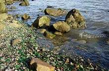
- Glass Beach is an unusual beach that is abundant in sea glass[30] created from years of dumping garbage into an area of the coastline. It is located below the 12th Street Park.
- A segment of the bicycle/pedestrian San Francisco Bay Trail runs through the Benicia State Recreational Area and downtown Benicia
- Benicia Arsenal
- Benicia Main Street: First Street-Shopping, Dining and Business district
- Pete Lemone's Historical House of Mystery
- Alverez 9th Street Park (AKA the 9th Street Pier) has boat landing, beach area and a playground for kids.
- the old Benicia tavern behind the parking lot of rookies bar and grill. where gold was first shown to the public starting the California gold rush.[31]
Schools
The Benicia Unified School District operates public schools.
- Elementary
- Matthew Turner Elementary School (named after a famous local shipbuilder)
- Robert Semple Elementary School (named after one of the city's founders)
- Mary Farmar Elementary School
- Joe Henderson Elementary School (named after a local educator and school superintendent)
- Middle schools
- Benicia Middle School[32]
- High schools
- Benicia High School
- Liberty High School
Notable people
Artists and designers
- Robert Arneson (1930–1992), sculptor, and professor of ceramics in the Art Department at UC Davis.
- Linda Fleming (born 1945), sculptor, and professor of art at CCA.
- Addison Mizner (1872–1933), visionary resort architect, born in Benicia.
- Manuel Neri (born 1930), sculptor, has had a studio in Benicia since 1965.
- Guillermo Wagner Granizo (1923–1995) ceramic tile muralist, moved to Benicia in 1980.
Politics
- Serranus Clinton Hastings, U.S. Congressman and founder of the Hastings College of the Law at University of California[33]
- Lansing Mizner, Solano County judge and president of the California Senate
Sports
- Austin Carr, NFL Football Player for the New Orleans Saints
- John C. Heenan, boxer, aka "The Benicia Boy"
- Willie Calhoun, professional baseball player for the Texas Rangers
Writers
- Stephen Vincent Benet, author of The Devil and Daniel Webster and other stories and poems, lived in the Arsenal as a young boy
- James Lloyd Breck, Episcopalian priest
- Jack London, author, worked in the local fishing industry, and began writing while living in Benicia
- Wilson Mizner, playwright, born in Benicia
References
- "California Cities by Incorporation Date". California Association of Local Agency Formation Commissions. Archived from the original (Word) on November 3, 2014. Retrieved August 25, 2014.
- "City Council". City of Benicia. Retrieved September 20, 2014.
- "Statewide Database". UC Regents. Retrieved December 5, 2014.
- "California's 5th Congressional District - Representatives & District Map". Civic Impulse, LLC.
- "2016 U.S. Gazetteer Files". United States Census Bureau. Archived from the original on August 24, 2017. Retrieved July 19, 2017.
- "Benicia". Geographic Names Information System. United States Geological Survey. Retrieved October 20, 2014.
- "Benicia (city) QuickFacts". United States Census Bureau. Archived from the original on March 23, 2015. Retrieved March 15, 2015.
- "Population and Housing Unit Estimates". Retrieved May 21, 2020.
- "Arsenal History". Friends of the Benicia Arsenal. Retrieved May 22, 2020.
- "California Main Street Program". CA State Parks. Archived from the original on October 23, 2017. Retrieved March 30, 2019.
- Virtual Museum of the City of San Francisco Archived April 15, 2010, at the Wayback Machine
- Sherman, William Tecumseh (2011-11-21). The Memoirs of General W.T. Sherman: All Volumes (Illustrated) (Kindle Locations 1333). Kindle Edition.
- https://www.ci.benicia.ca.us/history
- "1860 to 1861 – The Pony Express". Benicia Historical Museum. Archived from the original on May 18, 2007. Retrieved April 25, 2015.CS1 maint: unfit url (link)
- Harris, Robert L. "The Railroad Ferry Steamer "Solano" Archived July 21, 2013, at the Wayback Machine. American Society of Civil Engineers, "Transactions" Vol XXII, April, 1890.
- Associated Press, “Historic State Capital Saved - Benicia Loses Famed 100-Year-Old Brewery”, The San Bernardino Daily Sun, San Bernardino, California, Friday 23 March 1945, Volume 51, page 2.
- "Arts Benicia". artsbenicia.org. Archived from the original on April 1, 2015. Retrieved April 25, 2015.
- "Archived copy". Archived from the original on July 25, 2011. Retrieved 2009-03-15.CS1 maint: archived copy as title (link)
- "Benicia Peddlers Fair ~ Since 1963". beniciapeddlersfair.org. Archived from the original on December 18, 2014. Retrieved April 25, 2015.
- "B.D.E.S. Benicia Holy Ghost Society". beniciaholyghost.org. Archived from the original on July 25, 2011. Retrieved April 25, 2015.
- "Events". beniciatrees.org. Archived from the original on December 18, 2014. Retrieved April 25, 2015.
- "Let's get arboreal: City planning Arbor Day tours, demos". The Benicia Herald. Archived from the original on January 23, 2015. Retrieved April 25, 2015.
- "Census of Population and Housing". Census.gov. Retrieved June 4, 2015.
- "2010 Census Interactive Population Search: CA – Benicia city". U.S. Census Bureau. Archived from the original on January 14, 2016. Retrieved July 12, 2014.
- "U.S. Census website". United States Census Bureau. Retrieved 2008-01-31.
- Bureau, U.S. Census. "American FactFinder – Community Facts". census.gov. Archived from the original on February 10, 2020. Retrieved January 17, 2017.
- "City of Benicia CAFR" (PDF). Archived from the original (PDF) on September 26, 2013. Retrieved February 25, 2012.
- "District 4 – Benicia-Martinez Bridge". ca.gov. Archived from the original on April 26, 2015. Retrieved April 25, 2015.
- Benicia Marina Archived June 8, 2007, at the Wayback Machine
- "Mobile Web Page". weather.com. Archived from the original on January 14, 2016. Retrieved April 25, 2015.
- https://www.ci.benicia.ca.us/history
- "Benicia Middle School: Home Page". schoolloop.com. Archived from the original on April 29, 2015. Retrieved April 25, 2015.
- "HASTINGS, Serranus Clinton, (1813 – 1893)". Biographical Directory of the United States Congress. Archived from the original on June 8, 2007. Retrieved March 12, 2014.
- "Archived copy". Archived from the original on February 7, 2017. Retrieved February 6, 2017.CS1 maint: archived copy as title (link)
External links
| Wikimedia Commons has media related to Benicia, California. |
| Wikivoyage has a travel guide for Benicia. |
- Official website
- Benicia Chamber of Commerce
- Benicia Main Street
- Benicia Historical Museum
- Benicia Public Library
- Arts Benicia
- Benicia Downtown Historic District — historical descriptions and maps.
- History of California State Capital
- Benicia Martinez Bridge
- Benicia State Recreational Area
- Benicia Tree Foundation
| Bodies of water |
|  |
|---|---|---|
| Counties | ||
| Major cities | ||
| Cities and towns 100k–250k | ||
| Cities and towns 50k–99k | ||
| Cities and towns 25k–50k | ||
| Cities and towns 10k–25k |
| |
| Sub-regions | ||
Municipalities and communities of Solano County, California, United States | ||
|---|---|---|
| Cities | 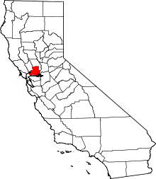 Solano County map | |
| CDPs | ||
| Unincorporated communities | ||
| Ghost towns |
| |
Places adjacent to Benicia, California | ||||||||||
|---|---|---|---|---|---|---|---|---|---|---|
| ||||||||||
| Authority control |
|
|---|