Petaluma, California
Petaluma /pɛtəˈluːmə/ is a city in Sonoma County, part of the North Bay sub-region of the San Francisco Bay Area, located 37 mi (60 km) north of San Francisco. Its population was 57,941 according to the 2010 Census.[6]
Petaluma, California | |
|---|---|
City | |
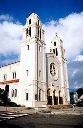
 .jpg)  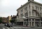  Clockwise: St. Vincent de Paul Church; Petaluma Historic Commercial District; U.S. Post Office; Petaluma Public Library; Rancho Petaluma. | |
 Location in Sonoma County and the state of California | |
 Petaluma, California Location in the United States | |
| Coordinates: 38°14′45″N 122°37′53″W | |
| Country | United States |
| State | California |
| County | Sonoma |
| Incorporated | April 12, 1858[1] |
| Government | |
| • Type | Council–manager |
| • Mayor | Teresa Barrett[2] |
| • Vice Mayor | Kevin McDonnell[2] |
| • City Manager | Peggy Flynn[3] |
| Area | |
| • Total | 14.49 sq mi (37.53 km2) |
| • Land | 14.38 sq mi (37.25 km2) |
| • Water | 0.11 sq mi (0.28 km2) 0.74% |
| Elevation | 30 ft (9 m) |
| Population | |
| • Total | 57,941 |
| • Estimate (2019)[7] | 60,520 |
| • Density | 4,208.73/sq mi (1,624.97/km2) |
| Time zone | UTC−8 (Pacific) |
| • Summer (DST) | UTC−7 (PDT) |
| ZIP codes | 94952, 94953, 94954 |
| Area code | 707 |
| FIPS code | 06-56784 |
| GNIS feature IDs | 277575, 2411407 |
| Website | cityofpetaluma |
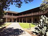
The Rancho Petaluma Adobe, located in Petaluma, is a National Historic Landmark. Its construction started in 1836 by order of General Mariano Guadalupe Vallejo, then Commandant of the San Francisco Presidio. It was the center of a 66,000 acre (270-km²) ranch stretching from Petaluma River to Sonoma Creek. The adobe is considered one of the best preserved buildings of its era in Northern California.
Petaluma is a transliteration of the Coast Miwok phrase péta lúuma which means hill backside.[8][9] Péta Lúuma was originally the name of a Miwok village located near the present day borders of the city of Petaluma.
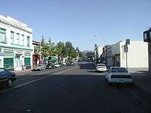
Petaluma has a well-preserved, historic city center[10] which includes many buildings that survived the 1906 San Francisco earthquake.
History

.jpg)
The Coast Miwok resided in southern Sonoma County, and Péta Lúuma was originally the name of a Miwok village east of the Petaluma River. A number of other Coast Miwok villages were also located in and around what is now Petaluma; Wotoki, immediately to the south of the village of Petaluma, on the opposite side of the river, Etem, Likatiut, and Tuchayalin, near downtown Petaluma, and Tulme and Susuli, just north of what are now the city limits of Petaluma.[11]
The Petaluma area was part of a 66,000 acre (270-km²) 1834 Mexican land grant by Governor Jose Figueroa to Mariano Guadalupe Vallejo called Rancho Petaluma. In 1836, Vallejo ordered construction of his Rancho Petaluma Adobe a ranch house in Petaluma, which his family often used as a summer home, while he resided in the neighboring town of Sonoma. Vallejo's influence and Mexican control in the region began to decline after Vallejo's arrest during the Bear Flag Revolt in 1846.
Pioneers moved to Petaluma from the eastern United States after James Marshall found gold in the Sierra Nevada in 1848. The town's position on the Petaluma River in the heart of productive farmland was critical to its growth during the 19th and early 20th centuries. Sailing scows, such as the scow schooner Alma (1892), and steamers plied the river between Petaluma and San Francisco, carrying agricultural produce and raw materials to the burgeoning city of San Francisco during the California Gold Rush.
There were brothels downtown along Petaluma Boulevard,[12] which used to be the main thoroughfare until U.S. Highway 101 was constructed in the 1950s.
The Sonoma County Bank Building was the home of the Baker Creek Heirloom Seed Company and the Petaluma Seed Bank for a time.[13] It was built in 1926.[14]
Petaluma soon became known for its grain milling and chicken processing industries, which continue to the present as a smaller fraction of its commerce. At one time, Petaluma was known as the "Egg Capital of the World," sparking such nicknames as "Chickaluma".[15] Petaluma hosted the only known Poultry drugstore and is the place where the egg incubator was invented by Lyman Byce in 1879. Petaluma is also where Randall Smith founded Mesa/Boogie (also known as Mesa Engineering), which manufactures high quality guitar and bass guitar amplification.
One of the largest historic chicken processing plants still stands in the central area of town; this 1930s brick building is no longer used for the chicken industry, but is being evaluated for preservation and change of use. Even though it is no longer known as the Egg Capital of the World, Petaluma maintains a strong agricultural base today with dairy farms, olive groves, vineyards, and berry and vegetable farms.
According to the Army Museum at the Presidio, San Francisco, Petaluma was relatively unharmed during the San Francisco earthquake of April 18, 1906, due to significant stable bedrock underlying the region.[16] As one of the few communities in the region left standing after the earthquake, Petaluma was the staging point for most Sonoma County rescue and relief efforts.
Petaluma is today the location of many distinguished, well-preserved pre-1906 buildings and Victorian homes on the western side of the river.[16] The downtown area has suffered many river floods over the years and during the Depression commerce declined. A lack of funds prevented the demolition of the old homes and buildings. In the 1960s there was a counter-culture migration out of San Francisco into Marin County and southern Sonoma County, looking for inexpensive housing in a less urban environment. The old Victorian, Queen Anne and Eastlake style houses were restored. Historic iron-front buildings in the downtown commercial district were also rescued. Traffic and new home development for the most part was rerouted to the east of downtown by the construction of the 101 freeway. The downtown Petaluma Historic Commercial District is on the National Register of Historic Places.
The first official airmail flight took place in 1911, when Fred Wiseman carried a handful of mail from Petaluma to Santa Rosa, including letters from Petaluma postmaster John E. Olmstead and Petaluma's mayor. Wiseman's plane ended up in the National Air and Space Museum.[17]
There was a substantial influx of Jewish residents, starting during World War I.[18] This community formed around shared socialist ideals, as well as religious and cultural ties; this is depicted in the movie A Home on the Range (2002).
With its large stock of historic buildings, Petaluma has been used as the filming location for numerous movies set in the 1940s, '50s, and '60s (see list of movies below). The historic McNear Building is a common film location.
Petaluma pioneered the time-controlled approach to development. After Highway 101 was re-aligned as a freeway in 1955, residential development permits tripled, from 300 in 1969 to 900 in 1971. Because of the region's soaring population in the sixties, the city enacted the "Petaluma Plan" in 1971. This plan limited the number of building permits to 500 annually for a five-year period beginning in 1972.[19] At the same time Petaluma created a redbelt around the town as a boundary for urban expansion for a stated number of years. Similar to Ramapo, New York, a Residential Development Control System was created to distribute the building permits based on a point system conforming to the city's general plan to provide for low and moderate income housing and divide development somewhat equally between east and west and single family and multi-family housing.
The stated objectives of Petaluma's time controlled growth management were to ensure orderly growth; to protect the city's small town character and surrounding green space; to provide a variety of housing choices; and to maintain adequate water supply and sewage treatment facilities.
The controlled development plan attracted national attention in 1975 when the city was taken to court by the Construction Industry Association. The city's restriction was upheld by the 9th Circuit Court in 1975 and the Supreme Court denied a Petition for Writ of Certiorari in 1976. This court ruling still forms the foundation for most local growth management ordinances in California.
Despite this history of planned development, the Petaluma City Council voted on April 13, 2009, to eliminate the entire planning department and lay off the whole planning staff.[20] Planning Division responsibilities were subsequently contracted out to the consulting firm Metropolitan Planning Group, which re-hired some of the former planning staff and continues to operate planning services for the city.
In the late 1990s, Petaluma was also known as Telecom Valley due to the telecom startup companies that seemed to multiply from one another, and offer great riches for early stockholders and employees. Two success stories were that of Advanced Fibre Communications (AFC) (now Tellabs), and Cerent, which was purchased by Cisco. Some Cerent employees went on to purchase the Phoenix Theater, a local entertainment venue, which was once an opera house.
The City has identified about two dozen buildings and districts as Petaluma landmarks.[21]
Geography

Petaluma has a total area of 14.5 sq mi (37.6 km2). 14.4 sq mi (37.3 km2) of that is land and the remaining 0.1 sq mi (0.3 km2) is water. Water is 0.74% of the total area.
It is 32 miles (51 km) north of San Francisco.[22]
Petaluma is flanked by the unincorporated communities of Penngrove to the north and Lakeville to the south.
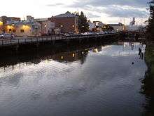
Petaluma is situated at the northernmost navigable end of the Petaluma River, a tidal estuary that snakes southward to San Pablo Bay. Pollution levels in the river, once considerable, have improved in recent years. A significant amount of the city is in the river's flood plain, which overflows its banks every few years, particularly in the Payran neighborhood.[10]
Principal environmental noise sources are U.S. Route 101, Petaluma Boulevard, Washington Street and other major arteries. The number of residents that live in a zone of noise exposure greater than 60 CNEL is approximately 4,000.[10]
Climate
Petaluma has a mild Mediterranean climate. Its dry summer is characterized by typically warm days and cool nights with a large degree of diurnal temperature variation. Summer mornings often start out foggy and chilly, but the fog usually clears by midday or so, giving way to clear skies and warmth for the remainder of the day. August is usually the warmest month, with average daily temperatures ranging from 82 °F (28 °C) to 53 °F (12 °C). December is usually the coldest month, with average daily temperatures ranging from 57 °F (14 °C) to 39 °F (4 °C). Winter is cool and rainy, with frost occasionally occurring on clear nights.
The National Weather Service's cooperative station in Petaluma had a record high temperature of 110 °F (43 °C) on June 2, 1960. The record low temperature of 16 °F (−9 °C) was recorded on November 14, 1916, and December 14, 1932. The wettest year was 1998 with 45.93 inches (1,167 mm) and the driest year was 1976 with 8.29 inches (211 mm). The wettest month was February 1998 with 19.59 inches (498 mm). The most precipitation in 24 hours was 4.29 inches (109 mm) on December 27, 2004. Although snow is rare in Petaluma, 1.5 inches fell in January 1916, as well as about 3 inches in January 2002.[23]
| Climate data for Petaluma, CA (1981–2010 normals) | |||||||||||||
|---|---|---|---|---|---|---|---|---|---|---|---|---|---|
| Month | Jan | Feb | Mar | Apr | May | Jun | Jul | Aug | Sep | Oct | Nov | Dec | Year |
| Average high °F (°C) | 56.9 (13.8) |
61.3 (16.3) |
64.3 (17.9) |
67.8 (19.9) |
72.2 (22.3) |
78.1 (25.6) |
81.8 (27.7) |
81.7 (27.6) |
81.4 (27.4) |
75.8 (24.3) |
65.4 (18.6) |
57.6 (14.2) |
70.4 (21.3) |
| Average low °F (°C) | 37.6 (3.1) |
40.2 (4.6) |
41.5 (5.3) |
43.3 (6.3) |
46.4 (8.0) |
49.8 (9.9) |
51.3 (10.7) |
51.5 (10.8) |
50.6 (10.3) |
47.0 (8.3) |
41.3 (5.2) |
38.1 (3.4) |
44.9 (7.2) |
| Average precipitation inches (mm) | 5.33 (135) |
4.57 (116) |
3.25 (83) |
1.58 (40) |
.63 (16) |
.20 (5.1) |
.02 (0.51) |
.06 (1.5) |
.24 (6.1) |
1.28 (33) |
2.96 (75) |
4.78 (121) |
24.89 (632) |
| Source: [24] | |||||||||||||
Demographics
| Historical population | |||
|---|---|---|---|
| Census | Pop. | %± | |
| 1880 | 3,326 | — | |
| 1890 | 3,692 | 11.0% | |
| 1900 | 3,871 | 4.8% | |
| 1910 | 5,880 | 51.9% | |
| 1920 | 6,226 | 5.9% | |
| 1930 | 8,245 | 32.4% | |
| 1940 | 8,034 | −2.6% | |
| 1950 | 10,315 | 28.4% | |
| 1960 | 14,035 | 36.1% | |
| 1970 | 24,870 | 77.2% | |
| 1980 | 33,834 | 36.0% | |
| 1990 | 43,184 | 27.6% | |
| 2000 | 54,548 | 26.3% | |
| 2010 | 57,941 | 6.2% | |
| Est. 2019 | 60,520 | [7] | 4.5% |
| U.S. Decennial Census[25] | |||
2010
The 2010 United States Census[26] reported that Petaluma had a population of 57,941. The population density was 3,998.9 people per square mile (2,590/km²). The racial makeup of Petaluma was 46,566 (80.4%) White, 801 (1.4%) African American, 353 (0.6%) Native American, 2,607 (4.5%) Asian (1.3% Chinese, 0.9% Filipino, 0.8% Asian Indian, 0.4% Japanese, 0.3% Vietnamese, 0.2% Korean, 0.1% Pakistani, 0.1% Laotian, 0.1% Thai), 129 (0.2%) Pacific Islander, 5,103 (8.8%) from other races, and 2,382 (4.1%) from two or more races. Hispanic or Latino of any race were 12,453 persons (21.5%). The Latino ethnic groups are Mexicans (16.2%), Salvadorans (1.2%), Guatemalans (0.6%), Nicaraguans (0.3%), Peruvians (0.3%), and Puerto Ricans (0.3%).
The Census reported that 57,217 people (98.8% of the population) lived in households, 361 (0.6%) lived in non-institutionalized group quarters, and 363 (0.6%) were institutionalized.
There were 21,737 households, out of which 7,541 (34.7%) had children under the age of 18 living in them, 11,392 (52.4%) were opposite-sex married couples living together, 2,257 (10.4%) had a female householder with no husband present, 1,052 (4.8%) had a male householder with no wife present. There were 1,319 (6.1%) unmarried opposite-sex partnerships, and 207 (1.0%) same-sex married couples or partnerships. 5,372 households (24.7%) were made up of individuals and 2,366 (10.9%) had someone living alone who was 65 years of age or older. The average household size was 2.63. There were 14,701 families (67.6% of all households); the average family size was 3.14.
The population was spread out with 13,455 people (23.2%) under the age of 18, 4,589 people (7.9%) aged 18 to 24, 15,041 people (26.0%) aged 25 to 44, 17,273 people (29.8%) aged 45 to 64, and 7,583 people (13.1%) who were 65 years of age or older. The median age was 40.3 years. For every 100 females, there were 96.3 males. For every 100 females age 18 and over, there were 93.8 males.
There were 22,736 housing units at an average density of 1,569.2 per square mile (605.9/km²), of which 14,159 (65.1%) were owner-occupied, and 7,578 (34.9%) were occupied by renters. The homeowner vacancy rate was 1.3%; the rental vacancy rate was 4.8%. 37,389 people (64.5% of the population) lived in owner-occupied housing units and 19,828 people (34.2%) lived in rental housing units.
2000
As of the census[27] of 2000, there were 54,548 people, 19,932 households, and 14,012 families residing in the city. The population density was 3,953 people per square mile (2,590/km²). There were 20,304 housing units at an average density of 1,471/sq mi (568/km²). The racial makeup of the city was 84.16% White, 1.16% African American, 0.54% Native American, 3.91% Asian, 0.17% Pacific Islander, 6.08% from other races, and 3.98% from two or more races. 14.64% of the population were Hispanic.
There were 19,932 households out of which 36.6% had children under the age of 18 living with them, 55.3% were married couples living together, 10.6% had a female householder with no husband present, and 29.7% were non-families. 22.6% of all households were made up of individuals and 9.1% had someone living alone who was 65 years of age or older. The average household size was 2.70 and the average family size was 3.16. The age distribution is: 26.2% under the age of 18, 7.2% from 18 to 24, 31.5% from 25 to 44, 24.1% from 45 to 64, and 11.0% who were 65 years of age or older. The median age was 37 years. For every 100 females, there were 95.6 males. For every 100 females age 18 and over, there were 91.9 males.
The median income for a household in the city was $61,679, and the median income for a family was $71,158 (these figures had risen to $68,949 and $85,513 respectively as of a 2007 estimate[28]). Males had a median income of $50,232 versus $36,413 for females. The per capita income for the city was $27,087. About 3.3% of families and 6.0% of the population were below the poverty line, including 6.2% of those under age 18 and 7.1% of those age 65 or over.
Economy
Amy's Kitchen, Calix, CamelBak, Clover Stornetta Farms, Lagunitas Brewing Company, Petaluma Poultry and Athleta Inc. are based in Petaluma.
Top employers
According to the City's 2019 Comprehensive Annual Financial Report,[29] the top employers in the city are:
| 1 | Petaluma School District | 813 | 2.43% |
| 2 | Petaluma Poultry Processors | 474 | 1.42% |
| 3 | Enphase Energy, Inc. | 468 | 1.40% |
| 4 | Petaluma Valley Hospital | 386 | 1.16% |
| 5 | City of Petaluma | 364 | 1.09% |
| 6 | Lagunitas Brewing Company | 350 | 1.05% |
| 7 | Old Adobe Union School District | 286 | 0.86% |
| 8 | Santa Rosa Junior College | 284 | 0.85% |
| 9 | Clover Stornetta Farms | 256 | 0.77% |
| 10 | Hansel Auto | 238 | 0.71% |
Military
U.S. Coast Guard
The U.S. Coast Guard operates Training Center Petaluma just outside Petaluma, near Two Rock. It operates several of its class "A" and "C" schools at TRACEN Petaluma including the Electronics Technician (ET), Culinary Specialist (CS), Health Service Technician (HS), Information Systems Technician (IT), Operation Specialist (OS), Storekeeper (SK), and Yeoman (YN) schools.
The Coast Guard also operates the Chief Petty Officer Academy at the TRACEN.[30] Academy trains senior non-commissioned officers (Chief Petty Officers) for both the U.S. Coast Guard and the U.S. Air Force.
California National Guard
The California National Guard operates an armed forces facility in Petaluma, at 580 Vallejo Street.
Parks and recreation
Immediately to the southwest is Helen Putnam Regional Park, accessible from Chileno Valley Road. This park of 216 acres (0.9 km2) has trails for hiking, cycling and horseback riding and is one of two parks named in honor of former mayor Helen Putnam who served from 1965–1979; the other is Putnam Plaza on Petaluma Boulevard. Lying above the city of Petaluma on the northwest flank of Sonoma Mountain is the Fairfield Osborn Preserve, a nature reserve with a diversity of native flora and fauna. Nearby to the southeast is Tolay Lake, the site of prehistoric seasonal settlement by Miwok and Pomo tribes.
Government
Local
The mayor of Petaluma is Teresa Barrett,[31] who was formerly the vice mayor, and has previously served on the Petaluma City Council.[32] The other six council members are Kevin McDonnell (Vice Mayor), D'Lynda Fisher, Mike Healy, Gabe Kearney, Dave King, and Kathy Miller.
State and federal representation
In the California State Legislature, Petaluma is in the 3rd Senate District, represented by Democrat Bill Dodd, and the 10th Assembly District, represented by Democrat Marc Levine.[33]
In the United States House of Representatives, Petaluma is split between California's 2nd congressional district, represented by Democrat Jared Huffman,[34] and California's 5th congressional district, represented by Democrat Mike Thompson.[35]
According to the California Secretary of State, as of February 10, 2019, Petaluma has 36,034 registered voters. Of those, 18,779 (52.1%) are registered Democrats, 6,124 (17%) are registered Republicans, and 9,281 (25.8%) have declined to state a political party.[36]
Education
Public schools are managed by the Petaluma City School District. There are two comprehensive high schools in Petaluma: Petaluma High School and Casa Grande High School, whose athletic teams are known as the Trojans and Gauchos respectively. Casa Grande High School has a notable Academic Decathlon team, which has represented Sonoma County for the last 27 years in the state-level competition. There is an annual football game between the two schools' teams known as the "Egg Bowl". The Game was suspended in 2011 for fights involving players and fans, but was brought back in 2017, with Petaluma winning the game over Casa Grande, 20–14. The two Petaluma public middle schools are Kenilworth Junior High School and Petaluma Junior High School.
St. Vincent de Paul High School, a Roman Catholic private school, is in Petaluma, and its athletic teams are known as the Mustangs. Santa Rosa Junior College has a second campus in Petaluma, and the campus the unaccredited art school/atelier l'Atelier aux Couleurs is located in Petaluma. Harvest Christian School is a Classical and Christian private school in Petaluma, serving grades TK-8.[37]
Infrastructure
Transportation
U.S. Highway 101 is the main freeway through town. State Route 116 also runs through town as Lakeville Highway. Other major streets include East Washington Street, North and South McDowell Boulevards, and Petaluma Boulevard.
Petaluma is served by Petaluma Transit, Golden Gate Transit and by Sonoma County Transit bus services. The Sonoma–Marin Area Rail Transit (SMART) rail line inaugurated service in August 2017 and serves Petaluma–Downtown station, adjacent to the historic Northwestern Pacific Railroad depot near Washington Street. A second station, Petaluma–North, is planned for future construction and service.
The nearest major airports are San Francisco International Airport and Oakland International Airport, Sonoma County Airport Express buses connect Petaluma with the aforementioned airports.[38] General aviation is served by the Petaluma Municipal Airport. Also the Charles M. Schulz – Sonoma County Airport located north of Santa Rosa.
Notable people
Actors
- Lloyd Bridges, actor[39]
- Myron Healey, actor[40]
- Daedalus Howell, actor[41]
- The Mommies, comedy duo
- Winona Ryder, actress[42]
Business
- Benjamin Trott, co-founder of Six Apart, creator of Movable Type and TypePad
- Mena Grabowski Trott, co-founder of Six Apart, creator of Movable Type and TypePad
Designers and artists
- Brainerd Jones, architect[43]
- Pele de Lappe, social realist painter and printmaker and political cartoonist.[44]
- Robert P. McChesney, visual artist[45]
- Alexander Sachal, painter, fine artist[46]
- Mark di Suvero, sculptor keeps a studio in Petaluma since 1975 and has a second art studio in New York City[39]
Video game designers
- Jake Rodkin, video game designer, graphic designer, podcaster
- Bill Tiller, computer game designer, writer, and artist, known for his work at LucasArts.
Historical figures
- William Eddy, prominent member and survivor of the Donner Party
- Wayne Adam Ford, Serial Killer
- Richard A. Penry, Medal of Honor recipient, U.S. Army soldier[47]
Musicians and bands
- Jared Emerson-Johnson, sound designer, video game music composer and voice actor
- Norman Greenbaum, singer songwriter
- Em Rossi, singer and songwriter[48]
- Tsunami Bomb, band
Politics
- Jackson Temple, Justice of the California Supreme Court
- Lynn Woolsey, U.S. Representative from California[49]
Sports figures
- Josh Akognon, basketball player
- Jon Andersen, wrestler
- Ben Bostrom, Pro AMA motorcycle racer
- Joe Enochs, soccer player for VfL Osnabrück
- Jonny Gomes, baseball player
- Duke Iversen, football player
- Spencer Torkelson baseball player
Writers
- Tobias Capwell (born c. 1973), American curator, military historian and jouster; born in Petaluma
- Clark Coolidge, poet
- Ryan Davis, video game journalist
- Jeff Gerstmann, video game journalist
- Daedalus Howell, writer
- Pauline Kael, movie critic, born in Petaluma
- Karen Kilgariff, comedian, podcaster and writer
- Leo Laporte,[50] technology journalist, previously of Tech TV, founder of TWiT
- Bill Pronzini, mystery writer
- Christina Hoff Sommers, author and equity feminist
- Silver Tree, film writer and producer[51]
Other
- Polly Klaas homicide victim
Petaluma in popular culture
- The song "Petaluma Afternoons" appeared on the 1998 record album Time Between Trains by folk singer Susan Werner.
- In the computer game Sim City 2000, "Petaluma" is frequently a neighboring community to the city that the player builds.
- The 2007 Michael Ondaatje novel Divisadero is partly set on a farm situated near Petaluma.
- A musical piece called And on the Seventh Day Petals Fell in Petaluma, inspired by a garden in Petaluma, was created by Harry Partch in 1963.
- Petaluma is briefly mentioned by a suitor in the 1971 comedy film Harold and Maude.
- In the episode of the television show M*A*S*H 'The Topper', character B.J. Hunnicutt mentions a "Petaluma lumberjack festival."
- In Nickelodeon's The Mighty B! a freeway overpass has a Petaluma sign on it.
- In the Peanuts comics series, Snoopy the beagle trains for an arm wrestling event in Petaluma (but is disqualified because he has no thumb).
- In an episode the 1970s television series Emergency!, firemen Chet Kelley mentions trying out for the Arm Wrestling Championship in Petaluma, but loses to another applicant before making the trip.
- In their song "Days of the Phoenix" from their September 2000 album titled The Art of Drowning, the punk rock band AFI makes reference to the Phoenix Theater on Washington Street in downtown Petaluma, a venue the band used to play on a regular basis.
- In the film "One Way Passage" starring William Powell, Kay Francis, Aline MacMahon, Frank McHugh, and Warren Hymer playing a police detective, Hymer tries to woo actress Aline MacMahon by telling her he wants to quit police work and retire to his fully paid for chicken ranch in Petaluma.
Film locations
Petaluma has served as a location for many major films and television commercials, including:
- American Graffiti[50] (1973) - Sonoma shooting was at Old Adobe Road, Frates Road, Petaluma Blvd., Gilardi's Baitshop on Bodega Avenue for the liquor store scene, Petaluma High School, and the downtown parking lot for the police car scene (also San Rafael and Tamalpais High School in Marin County).
- Heroes (1977) - Locations include Petaluma, California Petaluma Raceway.
- The Grass is Always Greener Over the Septic Tank (1978) - Filmed in a house at 121 Rancho Bonito Circle.
- Cujo (1983) - Locations include Petaluma, Santa Rosa and Mendocino.
- Morning in America (1984) Presidential Campaign ad for Ronald Reagan by Hal Riney
- Explorers (1985) - Locations include Petaluma.
- Howard the Duck (1986)
- Peggy Sue Got Married (1986) - Locations at Santa Rosa High School and Petaluma.
- Basic Instinct (1992) - Three-day shoot in Petaluma and Rohnert Park, with other scenes in Carmel and San Francisco.
- Merlin's Shop of Mystical Wonders (1996) - Exterior of the titular shop is on Kentucky Street. This film is mostly known for being featured on Mystery Science Theater 3000.
- Phenomenon (1996)
- Scream (1996) - Locations include Santa Rosa and Petaluma.
- Max, 13 (1997) - Four-day shoot in Petaluma and 10-day shoot in Tomales.
- Inventing the Abbotts (1997)
- Flubber (1997) - Church scene filmed partially at Open Door Christian church in Petaluma.
- Lolita (1997)
- Videoplasty (1998) - Concert footage of the funk metal outfit Primus, shot at the Phoenix Theatre.
- Pleasantville (1998) - Filmed at intersection of Petaluma Boulevard and Western Avenue.
- Mumford (1999)
- The Man Who Wasn't There (2001)
- Cheaper by the Dozen (2003)
- The Hamiltons (2005)
- Molotov Alva (2007)
- Beautiful Boy (2018)
Notable events
- Petaluma held the world wrist wrestling championships from 1952 to 2003, of which Hub "20 Pounds of Chicken a Day" Richmond won 19 times. Hub is also known for his appearances at gyms for bending bars and also setting world lifiting records on any given day. (The championships were moved to Reno, Nevada in 2004 due to a lack of sponsorship; the 2007 finals were held in Bulgaria.) In the comic strip Peanuts, Snoopy aspired to be a champion arm-wrestler (or "wrist-wrestler," as they were then called) and was shown in a series of 1968 comic strips headed for Petaluma. (He was disqualified, as he had no thumb.)[52]
- Petaluma received national attention when 12-year-old Polly Klaas was kidnapped from her home at knifepoint on October 1, 1993, and later raped and murdered by Richard Allen Davis. The community pulled quickly together to publicize the disappearance and to form the Polly Klaas Foundation for missing and exploited children.
- The Phoenix Theatre was the site of the punk/alt-rock band Sublime's last concert, the night before Brad Nowell's May 25, 1996 heroin overdose.[53]
- For the last 25 years Petaluma has played host to the World's Ugliest Dog Contest. Photos and results of the contest are typically reported worldwide. This annual event is held at the Sonoma-Marin Fair every Summer.[54]
- Petaluma hosts a "Butter and Egg Days Parade" in April of each year, celebrating its heritage as the "Egg Basket to the World" and dairy production.[55]
- In the 2012 Little League World Series, the Petaluma National All-Stars became the first Northern California team in the Little League World Series since Aptos in 2002.[56] The team finished in 3rd place.
- In 2013 The Petaluma Leghorns American Legion baseball team finished second out of over 4,500 US American Legion teams at the American Legion World Series played in Shelbyville, NC.
- Bill Soberanes: "Argus Courier columnist and Peopleologist. Petaluma's number one booster and founder of the World Wrist Wrestling Championship and numerous other events. Trade Mark - He's been photographed with more famous, infamous, usual and unusual people than anyone in the world. He's the World's Number One People Meeter." - From a tribute statue and plaque in downtown Petaluma.
See also
- KAFP (defunct)
- List of cities and towns in California
- List of cities and towns in the San Francisco Bay Area
- Petaluma Gap
- Petaluma Reservoir
- Petaluma Wildlife Museum
- United States Post Office (Petaluma, California)
References
- "California Cities by Incorporation Date". California Association of Local Agency Formation Commissions. Archived from the original (Word) on February 21, 2013. Retrieved August 25, 2014.
- "Petaluma City Council". City of Petaluma. Retrieved November 30, 2016.
- "City Manager". City of Petaluma. Retrieved November 9, 2014.
- "2016 U.S. Gazetteer Files". United States Census Bureau. Retrieved June 28, 2017.
- "Petaluma". Geographic Names Information System. United States Geological Survey.
- "Petaluma Quickfacts from the US Census Bureau". US Census Bureau. Archived from the original on January 1, 2012. Retrieved July 30, 2012.
- "Population and Housing Unit Estimates". Retrieved May 21, 2020.
- Gudde, Erwin Gustav; William Bright (1998). California Place Names: The Origin and Etymology of Current Geographical Names (Second ed.). Berkeley: University of California Press. pp. 287. ISBN 978-0-520-21316-6.
- Billiter, Bill (January 1, 1985). "3,000-Year-Old Connection Claimed : Siberia Tie to California Tribes Cited". Los Angeles Times. Los Angeles. Archived from the original on November 28, 2014. Retrieved November 28, 2014.
The similarities of the Siberian-California Indian words include some well-known places, he said. "Petaluma (a city in Northern California) would be understood in Siberia even today," he said. "It means 'flat back,' as in the flat back of a hill.
- Kay Ransom, C. Michael Hogan, Ballard George et al., Environmental Impact Report for the Petaluma General Plan, prepared by Earth Metrics Inc. for the city of Petaluma (1984),
- Peterson, Bonnie J. (1976). Dawn of the World: Coast Miwok Myths. ISBN 978-0-912908-04-5.
- "Old Chicago Pizza – Delicious Pizza Restaurant in Petaluma, California".
Aside from the pizza, you might be interested in knowing that the room you are sitting in was at one time the parlor for a house of ill-repute
- "Petaluma Seed Bank". Rareseeds.com.
- "Historic Downtown Petaluma Sites" (PDF). VisitPetaluma.com. September 28, 2019. Retrieved September 28, 2019.
- Harwood, W. S. (May 1908). "A City Of A Million Hens: How Poultry Raising Conducted As A Business Has Made Petaluma Known Over The World". The World's Work: A History of Our Time. XVI: 10207–10124. Retrieved July 10, 2009.
- "The History of Petaluma California". Petaluma.com. Retrieved November 17, 2017.
- "Fad to Fundamental: Airmail in America". Smithsonian Institution. Retrieved January 29, 2011.
- Fishkoff, Sue (May 7, 1999). "When left-wingers and chicken wings populated Petaluma". JWeekly. The Jewish News of Northern California. Retrieved September 14, 2012.
- Fulton, William, and Paul Shigley, Guide to California Planning, 3d edition, pp. 199-200. Point Arena, Calif.: Solano Press Books, 2005.
- Shigley, Paul, "Petaluma Eliminates Its Planning Department", California Planning & Development Report, April 14, 2009
- "City of Petaluma: Planning Department". Archived from the original on January 7, 2019. Retrieved January 13, 2019.
- Petaluma Visitors Center. Transportation. Archived June 3, 2017, at the Wayback Machine Retrieved on July 14, 2017.
- "Central California". dri.edu.
- "PETALUMA AP, CALIFORNIA - Climate Summary". dri.edu.
- "Census of Population and Housing". Census.gov. Retrieved June 4, 2015.
- "2010 Census Interactive Population Search: CA - Petaluma city". U.S. Census Bureau. Archived from the original on July 15, 2014. Retrieved July 12, 2014.
- "U.S. Census website". United States Census Bureau. Retrieved January 31, 2008.
- Petaluma City, California - Fact Sheet - American FactFinder (Census.gov)
- City of Petaluma CAFR Retrieved May 29, 2020
- "Chief Petty Officer Academy". United States Coast Guard. Retrieved November 17, 2017.
- "City of Petaluma: City Clerk, Petaluma City Council". Retrieved January 15, 2008.
- "City of Petaluma". Retrieved July 20, 2019.
- "Statewide Database". UC Regents. Archived from the original on February 1, 2015. Retrieved December 7, 2014.
- "California's 2nd Congressional District - Representatives & District Map". Civic Impulse, LLC. Retrieved March 1, 2013.
- "Communities of Interest - City". California Citizens Redistricting Commission. Archived from the original on September 30, 2013. Retrieved September 27, 2014.
- "CA Secretary of State – Report of Registration – February 10, 2019" (PDF). ca.gov. Retrieved March 12, 2019.
- "At a Glance". Harvest Christian School Petaluma.
- Sonoma County Airport Express Website
- "Petaluma home to famous artist". Santa Rosa Press Democrat. June 5, 2013. Retrieved May 30, 2019.
- "Myron Healey, 82; One of the Best Badmen in Film and TV Westerns". Los Angeles Times. March 27, 2006. ISSN 0458-3035. Retrieved May 30, 2019.
- Templeton, David. "'Pill Head' pops onto big screen". Petaluma360.com. Petaluma Argus-Courier. Retrieved May 3, 2019.
- "Sonoma County celebrity high school grads, now and then". Santa Rosa Press Democrat. August 28, 2017. Retrieved May 30, 2019.
- Weinstein, Dave (February 18, 2006). "The man who built Petaluma / Brainerd Jones designed much of what is now the city's historic section". SFGate. Retrieved May 30, 2019.
- Curiel, Jonathan (October 4, 2007). "Pele deLappe – artist, journalist, rights activist dead at 91". SFGate. Retrieved June 4, 2019.
- "True Bohemians, Artists Robert and Mary Fuller McChesney found peace outside the limelight". MetroActive. June 10, 2009. Retrieved November 8, 2014.
- "Petaluma artist Alexander Sachal". Santa Rosa Press Democrat. Retrieved May 30, 2019.
- "Medal of Honor Recipients: Vietnam (M-Z)". Retrieved October 19, 2009.
- "Singing her way to a career in music". Petaluma Argus Courier. July 16, 2015. Retrieved May 29, 2019.
- "WOOLSEY, *Lynn C." Retrieved October 19, 2009.
- carpoolUK (May 17, 2010), Leo Laporte | Carpool, retrieved October 2, 2017
- "The Wild Bunch". Retrieved October 19, 2009.
- "History of the Sport of Armwrestling". armwrestling.com.
- "Sublime Artistfacts". artistfacts.com.
- "World's Ugliest Dog - Sonoma Marin Fairgrounds & Event Center". Sonoma Marin Fairgrounds & Event Center. Retrieved November 11, 2015.
- "Butter And Eggs Day Parade". Archived from the original on May 5, 2010. Retrieved May 21, 2010.
- Shea, John (August 15, 2012). "Petaluma ballplayers chase world title". San Francisco Chronicle. Retrieved August 15, 2012.
External links
| Wikimedia Commons has media related to Petaluma, California. |
| Wikivoyage has a travel guide for Petaluma. |
- Official website

- Petaluma Downtown
- Petaluma 2004/05 General Plan
- Historical and scenic photos of Petaluma by Michael Maggid
- Bicycling map
Places adjacent to Petaluma, California | |
|---|---|
Municipalities and communities of Sonoma County, California, United States | ||
|---|---|---|
| Cities and towns | 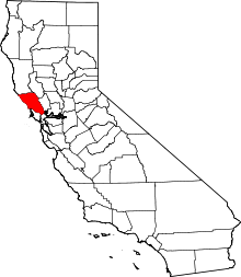 Sonoma County map | |
| CDPs |
| |
| Unincorporated communities | ||
| Indian reservations | ||
| Bodies of water |
|  |
|---|---|---|
| Counties | ||
| Major cities | ||
| Cities and towns 100k–250k | ||
| Cities and towns 50k–99k | ||
| Cities and towns 25k–50k | ||
| Cities and towns 10k–25k |
| |
| Sub-regions | ||
| Authority control |
|---|