Dixon, California
Dixon is a city in northern Solano County, California, United States, located 23 miles (37 km) from the state capital, Sacramento. The population was 18,351 at the 2010 census. Other nearby cities include Vacaville, Winters and Davis.
City of Dixon | |
|---|---|
City | |
 Aerial view of Dixon | |
 Seal | |
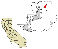 Location of Dixon in Solano County, California. | |
 City of Dixon Location in the United States | |
| Coordinates: 38°26′57″N 121°49′37″W | |
| Country | United States |
| State | California |
| County | Solano |
| Incorporated | March 30, 1878[1] |
| Government | |
| • Mayor | Thom Bogue [2] |
| • city manager | Jim Lindley[3] |
| • State senator | Bill Dodd (D)[4] |
| • Assemblymember | Cecilia Aguiar-Curry (D)[4] |
| • U. S. rep. | John Garamendi (D)[5] |
| Area | |
| • Total | 7.22 sq mi (18.71 km2) |
| • Land | 7.13 sq mi (18.46 km2) |
| • Water | 0.10 sq mi (0.25 km2) 1.36% |
| Elevation | 62 ft (19 m) |
| Population | |
| • Total | 18,351 |
| • Estimate (2019)[9] | 20,698 |
| • Density | 2,778.62/sq mi (1,072.90/km2) |
| Time zone | UTC−8 (Pacific) |
| • Summer (DST) | UTC−7 (PDT) |
| ZIP code | 95620 |
| Area code | 707 |
| FIPS code | 06-19402 |
| GNIS feature IDs | 1655973, 2410343 |
| Website | www |
History
The first semi-permanent European settlement to develop in the (now) Dixon area emerged during the California Gold Rush of the mid-19th century. During this time, the community of Silveyville was founded as a halfway point between the Pacific coast and the rich gold fields of Sacramento—along a route commonly traveled by miners. In 1868, Central Pacific railroad came through the area and missed Silveyville by a few miles.[10] As a result, local leaders decided to physically relocate Silveyville closer to the tracks in order to enjoy the benefits of commerce and travel. One of the first buildings that still stands in Dixon from the 1871 move is the Dixon Methodist Church located at 209 N. Jefferson Street.[11]
Originally, the city was named "Dicksonville" after Thomas Dickson who donated 10 acres of his land for the construction of a railroad depot following the completion of the tracks and subsequent relocation of Silveyville to the now-Dixon area. However, when the first rail shipment of merchandise arrived from San Francisco in 1872, it was mistakenly addressed to "Dixon"—a name that has been used since, mainly out of simplicity.[11] Up to now, the urban landscape of the town can be seen to have developed mostly in between the railroad tracks and Interstate-80.
The current city council consists of Steven C. Bird, Scott Pederson, Jim Ernest, and Devon Minnema.[2] Pederson and Ernest were elected in 2018. Mayor Thom Bogue, as well as Bird and Minnema, were elected in 2016 and they will be up for reelection in 2020.
The city operates a municipal police and fire department, and water system & wastewater treatment plant.
Dixon was the home of the Gymboree Corporation's only Distribution Center, servicing all stores and customers around the world prior to the bankruptcy and closing of the company.
Geography
Dixon is located at 38°26′57″N 121°49′37″W (38.449108, -121.826872).[12]
According to the United States Census Bureau, the city has a total area of 7.1 square miles (18 km2), of which, 7.0 square miles (18 km2) of it is land and 0.1 square miles (0.26 km2) of it (1.36%) is water.
Demographics
| Historical population | |||
|---|---|---|---|
| Census | Pop. | %± | |
| 1870 | 317 | — | |
| 1890 | 1,082 | — | |
| 1900 | 788 | −27.2% | |
| 1910 | 827 | 4.9% | |
| 1920 | 926 | 12.0% | |
| 1930 | 1,000 | 8.0% | |
| 1940 | 1,108 | 10.8% | |
| 1950 | 1,714 | 54.7% | |
| 1960 | 2,970 | 73.3% | |
| 1970 | 4,432 | 49.2% | |
| 1980 | 7,541 | 70.1% | |
| 1990 | 10,401 | 37.9% | |
| 2000 | 16,103 | 54.8% | |
| 2010 | 18,351 | 14.0% | |
| Est. 2019 | 20,698 | [9] | 12.8% |
| U.S. Decennial Census[13] | |||
2010
The 2010 United States Census[14] reported that Dixon had a population of 18,351. The population density was 2,587.7 people per square mile (999.1/km2). The racial makeup of Dixon was 13,023 (71.0%) White, 562 (3.1%) African American, 184 (1.0%) Native American, 671 (3.7%) Asian, 58 (0.3%) Pacific Islander, 2,838 (15.5%) from other races, and 1,015 (5.5%) from two or more races. Hispanic or Latino of any race were 7,426 persons (40.5%).
The Census reported that 100% of the population lived in households.
There were 5,856 households, out of which 2,773 (47.4%) had children under the age of 18 living in them, 3,550 (60.6%) were opposite-sex married couples living together, 790 (13.5%) had a female householder with no husband present, 339 (5.8%) had a male householder with no wife present. There were 327 (5.6%) unmarried opposite-sex partnerships, and 26 (0.4%) same-sex married couples or partnerships. 867 households (14.8%) were made up of individuals, and 301 (5.1%) had someone living alone who was 65 years of age or older. The average household size was 3.13. There were 4,679 families (79.9% of all households); the average family size was 3.47.
The population was spread out, with 5,349 people (29.1%) under the age of 18, 1,816 people (9.9%) aged 18 to 24, 5,026 people (27.4%) aged 25 to 44, 4,608 people (25.1%) aged 45 to 64, and 1,552 people (8.5%) who were 65 years of age or older. The median age was 33.3 years. For every 100 females, there were 97.8 males. For every 100 females age 18 and over, there were 94.8 males.
There were 6,172 housing units at an average density of 870.3 per square mile (336.0/km2), of which 3,902 (66.6%) were owner-occupied, and 1,954 (33.4%) were occupied by renters. The homeowner vacancy rate was 2.0%; the rental vacancy rate was 5.2%. 12,149 people (66.2% of the population) lived in owner-occupied housing units and 6,201 people (33.8%) lived in rental housing units.
2000
As of the census[15] of 2000, there were 16,103 people, 5,073 households, and 4,164 families residing in the city. The population density was 2,434.1 people per square mile (939.2/km2). There were 5,172 housing units at an average density of 781.8 per square mile (301.6/km2). The racial makeup of the city was 70.51% White, 1.93% Black or African American, 0.99% Native American, 3.11% Asian, 0.30% Pacific Islander, 17.87% from other races, and 5.29% from two or more races. 33.62% of the population were Hispanic or Latino of any race.
There were 5,073 households, out of which 47.8% had children under the age of 18 living with them, 67.0% were married couples living together, 9.7% had a female householder with no husband present, and 17.9% were non-families. 13.0% of all households were made up of individuals, and 4.5% had someone living alone who was 65 years of age or older. The average household size was 3.17 and the average family size was 3.45.
In the city, the population is concentrated among adults 25 to 44 (32.2%) and children under age 18 (32%). Only 8.5% of the population is aged 18 to 24; 20.0% from 45 to 64; and 7.2% who were 65 years of age or older. The median age was 32 years. For every 100 females, there were 100.3 males. For every 100 females age 18 and over, there were 97.8 males.
The median income for a household in the city was $54,472, and the median income for a family was $58,849. Males had a median income of $42,286 versus $30,378 for females. The per capita income for the city was $20,139. About 5.2% of families and 8.1% of the population were below the poverty line, including 9.1% of those under age 18 and 6.6% of those age 65 or over.
Notable sites
The Jackson Fay Brown House and the Dixon Carnegie library are on the National Register of Historic Places.[16]
As of 2014, Dixon residents Matt and Mark Cooley, owners of Cool Patch Pumpkins, hold the Guinness World Record for "largest maze, temporary corn/crop maze". The maze measured 163,853.83 m2 or 40.489 acres.[17] In 2012, Cool Patch Pumpkins broke its own record with a 53-acre maze.[18] In 2014 Cool Patch Pumpkins again broke its own record by growing a 60-acre maze.[19]
Notable people
- Jon Pardi - Country music singer and songwriter
- Nick Watney - Professional golfer
- Dave Ball - Professional NFL player
- Espinoza Paz - Latin Grammy-nominated Mexican musician and composer of Mexican regional music
- Joe Craven - Professional musician and music educator
Transportation
Interstate 80 passes through Dixon.
The Union Pacific Railroad mainline between Oakland and Sacramento also passes through Dixon. This line was owned by Southern Pacific Railroad until its merger with Union Pacific on September 11, 1996. The track was constructed in 1868 by the California Pacific Railroad.
Amtrak Capitol Corridor also passes through Dixon over the UP mainline but the nearest station stops are at Davis and Fairfield–Vacaville. Amtrak's California Zephyr and Coast Starlight also pass through Dixon without stopping.
In 2006, the City of Dixon finished construction on a train station near downtown Dixon. However, there are currently no scheduled stops at the station. The building has, for the time being, been converted to the city's Chamber of Commerce.
The town has public transit in Dixon Readi-Ride a dial-a-ride shuttlebus service. Dixon Park & Ride is a bus station in Dixon.[20] It is served by Fairfield and Suisun Transit route 30 that runs between Fairfield Transportation Center and downtown Sacramento.[21] Dixon Readi-Ride a dial-a-ride service also stops here.[22] It has 89 parking spots. The bus service lasts approximately 10 hours per day on route 30.[23]
Economy
Top employers
According to the City's 2011 Comprehensive Annual Financial Report,[24] the top employers in the city are:
| # | Employer | # of Employees |
|---|---|---|
| 1 | Gymboree | 400 |
| 2 | Wal-Mart | 317 |
| 3 | First Northern Bank | 233 |
| 4 | Campbell Soup Company | 180 |
| 5 | Cardinal Health | 153 |
| 6 | Superior Farms | 140 |
| 7 | Basalite | 139 |
| 8 | Altec | 127 |
| 9 | City of Dixon | 104 |
| 10 | Dependable Heating and Air Conditioning | 90 |
Radio transmissions
The Voice of America ran a shortwave transmitter site that was formerly owned and operated by NBC as KNBA from 1963–1982. NBC built the site in 1944 not too long before the end of World War II in 1945. The station served as a relay to both NBC International programming overseas, and as a relay of KNBR and its programming overseas, mostly the Pacific area.[25] There is also a military transmission site, the Dixon Naval Radio Transmitter Facility.
Education
High schools
- Dixon High School
- Maine Prairie High School (continuation school)
Middle schools
- C.A. Jacobs Intermediate
- Dixon Montessori Charter School
- Neighborhood Christian Middle School
Elementary schools
- Silveyville (Closed 2008)
- Anderson
- Gretchen Higgins
- Tremont
- Neighborhood Christian School
- Dixon Montessori Charter School (Now located in Silveyville facility)
- Easter Seals Special Education Center (shares Silveyville facility with DMCS)
See also
References
- "California Cities by Incorporation Date". California Association of Local Agency Formation Commissions. Archived from the original (Word) on November 3, 2014. Retrieved August 25, 2014.
- "City Council". Dixon, CA. Retrieved February 22, 2015.
- "City Manager". Dixon, CA. Retrieved April 16, 2015.
- "Statewide Database". Regents of the University of California. Retrieved February 22, 2015.
- "California's 3rd Congressional District - Representatives & District Map". Civic Impulse, LLC. Retrieved March 9, 2013.
- "2016 U.S. Gazetteer Files". United States Census Bureau. Retrieved July 19, 2017.
- "Dixon". Geographic Names Information System. United States Geological Survey. Retrieved February 26, 2015.
- "Dixon (city) QuickFacts". United States Census Bureau. Archived from the original on March 29, 2015. Retrieved April 9, 2015.
- "Population and Housing Unit Estimates". Retrieved May 21, 2020.
- "Once-bustling Silveyville a town that disappeared". January 6, 2013.
- "Visitors Guide". Dixon Chamber of Commerce online. Retrieved January 22, 2014.
- "US Gazetteer files: 2010, 2000, and 1990". United States Census Bureau. February 12, 2011. Retrieved April 23, 2011.
- "Census of Population and Housing". Census.gov. Retrieved June 4, 2015.
- "2010 Census Interactive Population Search: CA - Dixon city". U.S. Census Bureau. Archived from the original on July 15, 2014. Retrieved July 12, 2014.
- "U.S. Census website". United States Census Bureau. Retrieved 2008-01-31.
- "Ratcheting Up Solano Pride". Benicia magazine. March 2012. Retrieved April 6, 2019.
- "Largest maze, temporary corn/crop maze".
- "Cool Patch Pumpkins Corn Maze". Archived from the original on March 19, 2013.
- "Corn maze". Cool Patch Pumpkins. Archived from the original on February 25, 2015. Retrieved February 24, 2015.
- "route 30 schedule". Archived from the original on August 6, 2017. Retrieved August 6, 2017.
- Dixon Readi-Ride
- "Archived copy" (PDF). Archived from the original (PDF) on December 27, 2016. Retrieved August 6, 2017.CS1 maint: archived copy as title (link)
- City of Dixon CAFR Archived August 3, 2014, at the Wayback Machine
- Stevenson, Merrill (June 30, 2016). "The Mystery of the Dixon Voice of America Relay Station". eham.net. Archived from the original on December 26, 2017. Retrieved February 25, 2018.
External links
| Wikimedia Commons has media related to Dixon, California. |
- Official website

- Dixon Unified School District California State Accountability Report Cards
- Dixon, California at Curlie
Municipalities and communities of Solano County, California, United States | ||
|---|---|---|
| Cities | 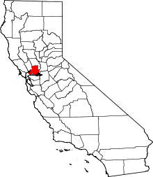 Solano County map | |
| CDPs | ||
| Unincorporated communities | ||
| Ghost towns |
| |
| Bodies of water |
|  |
|---|---|---|
| Counties | ||
| Major cities | ||
| Cities and towns 100k–250k | ||
| Cities and towns 50k–99k | ||
| Cities and towns 25k–50k | ||
| Cities and towns 10k–25k |
| |
| Sub-regions | ||

| Authority control |
|
|---|