Belmont, California
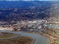
Belmont is a city in San Mateo County in the U.S. state of California. It is in the San Francisco Bay Area, on the San Francisco Peninsula halfway between San Francisco and San Jose. It was originally part of Rancho de las Pulgas, for which one of its main roads, the Alameda de las Pulgas, is named. The city was incorporated in 1926. Its population was 25,835 at the 2010 census.
Belmont, California | |
|---|---|
City | |
| City of Belmont | |
 | |
 Seal | |
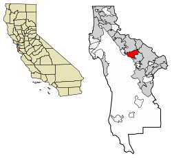 Location of Belmont in San Mateo County, California | |
 Belmont, California Location in the United States | |
| Coordinates: 37°31′5″N 122°17′30″W | |
| Country | |
| State | |
| County | San Mateo |
| Incorporated | October 29, 1926[1] |
| Government | |
| • Mayor | Warren Lieberman[2] |
| Area | |
| • Total | 4.64 sq mi (12.02 km2) |
| • Land | 4.63 sq mi (12.00 km2) |
| • Water | 0.01 sq mi (0.02 km2) 0.19% |
| Elevation | 43 ft (13 m) |
| Population | |
| • Total | 25,835 |
| • Estimate (2019)[6] | 26,941 |
| • Density | 5,843.98/sq mi (2,256.45/km2) |
| Time zone | UTC-8 (Pacific) |
| • Summer (DST) | UTC-7 (PDT) |
| ZIP code | 94002 |
| Area code | 650 |
| FIPS code | 06-05108 |
| GNIS feature IDs | 1658029, 2409826 |
| Website | www |
Ralston Hall is a historic landmark built by Bank of California founder William Chapman Ralston on the campus of Notre Dame de Namur University, and is also home to Notre Dame High School. It was built around a villa formerly owned by Count Cipriani, an Italian aristocrat. The locally famous "Waterdog Lake" is also located in the foothills and highlands of Belmont.
One of two surviving structures from the Panama-Pacific International Exposition is on Belmont Avenue (the other is the Palace of Fine Arts in San Francisco). The building was brought to Belmont by E.D. Swift shortly after the exposition closed in 1915. Swift owned a large amount of land in the area.
Belmont has attracted national attention for a smoking ordinance passed in January 2009 which bans smoking in all businesses and multi-story apartments and condominiums; the ordinance has been described as one of the strictest in the nation.
Etymology
The name seems to derive from the Italian "bel monte," which means "beautiful mountain." It was allegedly named such because of its "symmetrically rounded eminence" nearby.[7]
Geography
Belmont is located at 37°31′5″N 122°17′30″W (37.518087, -122.291673).[8]
According to the United States Census Bureau, the city has a total area of 4.20 square miles (10.9 km2) of which 4.6 square miles (12 km2) is land and 0.19% is water.
Demographics
| Historical population | |||
|---|---|---|---|
| Census | Pop. | %± | |
| 1880 | 202 | — | |
| 1930 | 984 | — | |
| 1940 | 1,229 | 24.9% | |
| 1950 | 5,567 | 353.0% | |
| 1960 | 15,996 | 187.3% | |
| 1970 | 23,538 | 47.1% | |
| 1980 | 24,505 | 4.1% | |
| 1990 | 24,127 | −1.5% | |
| 2000 | 25,123 | 4.1% | |
| 2010 | 25,835 | 2.8% | |
| Est. 2019 | 26,941 | [6] | 4.3% |
| U.S. Decennial Census[9] | |||
2010
At the 2010 census Belmont had a population of 25,835. The population density was 5,579.8 people per square mile (2,154.4/km²). The racial makeup of Belmont was 17,455 (67.6%) White, 420 (1.6%) African American, 72 (0.3%) Native American, 5,151 (19.9%) Asian, 198 (0.8%) Pacific Islander, 964 (3.7%) from other races, and 1,572 (6.1%) from two or more races. Hispanic or Latino of any race were 2,977 persons (11.5%).[10]
The census reported that 25,321 people (98.0% of the population) lived in households, 394 (1.5%) lived in non-institutionalized group quarters, and 120 (0.5%) were institutionalized.
There were 10,575 households, 3,251 (30.7%) had children under the age of 18 living in them, 5,630 (53.2%) were opposite-sex married couples living together, 830 (7.8%) had a female householder with no husband present, 391 (3.7%) had a male householder with no wife present. There were 510 (4.8%) unmarried opposite-sex partnerships, and 96 (0.9%) same-sex married couples or partnerships. 2,904 households (27.5%) were one person and 997 (9.4%) had someone living alone who was 65 or older. The average household size was 2.39. There were 6,851 families (64.8% of households); the average family size was 2.95.
The age distribution was 5,395 people (20.9%) under the age of 18, 1,668 people (6.5%) aged 18 to 24, 7,645 people (29.6%) aged 25 to 44, 7,284 people (28.2%) aged 45 to 64, and 3,843 people (14.9%) who were 65 or older. The median age was 40.9 years. For every 100 females, there were 95.4 males. For every 100 females age 18 and over, there were 92.5 males.
There were 11,028 housing units at an average density of 2,381.8 per square mile, of the occupied units 6,280 (59.4%) were owner-occupied and 4,295 (42.0%) were rented.The homeowner vacancy rate was 0.7%; the rental vacancy rate was 5.2%. 16,473 people (63.8% of the population) lived in owner-occupied housing units and 8,848 people (34.2%) lived in rental housing units.
2000
At the 2000 census there were 25,123 people in 10,418 households, including 6,542 families, in the city. The population density was 5,551.1 people per square mile (2,141.3/km²). There were 10,577 housing units at an average density of 2,337.1 per square mile (901.5/km²).[11] Of the 10,418 households 26.4% had children under the age of 18 living with them, 52.6% were married couples living together, 7.1% had a female householder with no husband present, and 37.2% were non-families. 27.2% of households were one person and 7.3% were one person aged 65 or older. The average household size was 2.35 and the average family size was 2.89.
The age distribution was 19.3% under the age of 18, 6.5% from 18 to 24, 35.9% from 25 to 44, 25.1% from 45 to 64, and 13.2% 65 or older. The median age was 39 years. For every 100 females, there were 96.7 males. For every 100 females age 18 and over, there were 94.6 males.
According to a 2007 estimate, the median income for a household in the city was $99,739, and the median family income was $122,515.[12] Males had a median income of $63,281 versus $46,957 for females. The per capita income for the city was $42,812. About 1.7% of families and 4.0% of the population were below the poverty line, including 3.2% of those under age 18 and 4.8% of those age 65 and over.
In May 2009, Belmont was ranked 11th on Forbes list of "America's Top 25 Towns to Live Well."[13]
Government
Federal and state representation
In the California State Legislature, Belmont is in the 13th Senate District, represented by Democrat Jerry Hill, and in the 22nd Assembly District, represented by Democrat Kevin Mullin.[14]
Federally, Belmont is in California's 14th congressional district, represented by Democrat Jackie Speier.[15]
According to the California Secretary of State, as of February 10, 2019, Belmont has 15,827 registered voters. Of those, 7,678 (48.5%) are registered Democrats, 2,540 (16%) are registered Republicans, and 4,994 (31.6%) have declined to state a political party.[16]
Facilities
The city is served by the Belmont Public Library of the San Mateo County Libraries, a member of the Peninsula Library System.
The city has a number of parks. This includes Twin Pines Park, Waterdog Lake Open Space,[17] Semeria Park and Davey Glen Park.
Child education is provided by public and private facilities. Students in Belmont are eligible to receive public schooling through two school districts:[18] Belmont-Redwood Shores School District (kindergarten through middle school)[19] and Sequoia Union High School District (high school).[20] There are also several private schools.[18] The private Charles Armstrong School specializes in language-based learning differences, such as dyslexia.
The city's largest hotel is Hyatt House, which is an apartment hotel and caters mostly to a business clientele, due to its proximity to Oracle headquarters.
Smoking policy
In January 2009, Belmont adopted an ordinance that bans smoking in city parks, all businesses, and all multi-story apartments and condominiums. The policy, which has been described as perhaps the strictest anti-smoking law in the nation, was the result of a group of retirees lobbying the city to stop secondhand smoke from drifting into their apartments from neighboring places. Public health advocates consider the ordinance to be a new front in a national battle against tobacco; officials from the American Lung Association of California said "Belmont broke through this invisible barrier in the sense that it addressed drifting smoke in housing as a public health issue."[21]
Economy
Top employers
According to the city's 2011 Comprehensive Annual Financial Report,[22] the top employers in the city are:
| # | Employer | # of Employees |
|---|---|---|
| 1 | Oracle | 500 to 999 |
| 2 | Cengage Learning | 250 to 499 |
| 3 | Volkswagen Electronics Research Laboratory | 100 to 249 |
| 4 | Nikon Precision | 100 to 249 |
| 5 | Safeway | 100 to 249 |
| 6 | Autobahn Motors | 100 to 249 |
| 7 | Silverado Senior Living | 100 to 249 |
| 8 | Carlmont Gardens | 75 to 100 |
| 9 | Lunardi's | 75 to 100 |
| 10 | Jameco Electronics | 75 to 100 |
Sister cities
See also
References
- "California Cities by Incorporation Date". California Association of Local Agency Formation Commissions. Archived from the original (Word) on November 3, 2014. Retrieved August 25, 2014.
- "City Council - City of Belmont". Retrieved December 21, 2019.
- "2016 U.S. Gazetteer Files". United States Census Bureau. Retrieved July 19, 2017.
- "Belmont". Geographic Names Information System. United States Geological Survey. Retrieved October 20, 2014.
- "Belmont (city) QuickFacts". United States Census Bureau. Archived from the original on April 2, 2015. Retrieved March 31, 2015.
- "Population and Housing Unit Estimates". Retrieved May 21, 2020.
- Gudde, Erwin G. "California Place Names: The Origin and Etymology of Current Geographical Names," 4th ed. University of California Press, p. 31-32
- "US Gazetteer files: 2010, 2000, and 1990". United States Census Bureau. February 12, 2011. Retrieved April 23, 2011.
- "Census of Population and Housing". Census.gov. Retrieved June 4, 2015.
- "2010 Census Interactive Population Search: CA - Belmont city". U.S. Census Bureau. Archived from the original on July 15, 2014. Retrieved July 12, 2014.
- "U.S. Census website". United States Census Bureau. Retrieved 2008-01-31.
- American FactFinder. Factfinder.census.gov. Retrieved on 2013-07-21.
- Woolsey, Matt. "In Depth: America's Top 25 Towns To Live Well". Forbes.
- "Statewide Database". UC Regents. Archived from the original on February 1, 2015. Retrieved December 29, 2014.
- "California's 14th Congressional District - Representatives & District Map". Civic Impulse, LLC. Retrieved March 13, 2013.
- "CA Secretary of State – Report of Registration – February 10, 2019" (PDF). ca.gov. Retrieved March 12, 2019.
- "Waterdog trail map".
- "Belmont, CA Schools".
- "Belmont-Redwood Shores School District". Archived from the original on June 26, 2012.
- "Sequoia Union High School District". Archived from the original on October 16, 2012.
- McKinley, Jesse. "Smoking Ban Hits Home. Truly." The New York Times, January 26, 2009. Retrieved on 2009-01-26.
- City of Belmont CAFR Archived April 25, 2012, at the Wayback Machine
External links
| Wikivoyage has a travel guide for Belmont (California). |
- Official website

- Belmont information resource from the Belmont Chamber of Commerce
- Belmont Public Library - a branch of the San Mateo County Library
Municipalities and communities of San Mateo County, California, United States | ||
|---|---|---|
| Cities and towns | 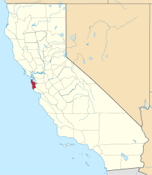 San Mateo County map | |
| CDPs | ||
| Unincorporated communities | ||
| Ghost towns | ||
| Bodies of water |
|  |
|---|---|---|
| Counties | ||
| Major cities | ||
| Cities and towns 100k–250k | ||
| Cities and towns 50k–99k | ||
| Cities and towns 25k–50k | ||
| Cities and towns 10k–25k |
| |
| Sub-regions | ||
| Authority control |
|
|---|