Gilroy, California
Gilroy (/ˈɡɪlrɔɪ/) is a city in Northern California's Santa Clara County, south of Morgan Hill and north of San Benito County. The city's population was 48,821 at the 2010 United States Census.
Gilroy, California | |
|---|---|
City | |
| City of Gilroy | |
 Old City Hall in April 2014 | |
 Flag  Seal | |
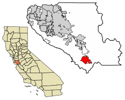 Location of Gilroy in Santa Clara County, California | |
 Gilroy, California Location in the United States | |
| Coordinates: 37°0′43″N 121°34′48″W | |
| Country | |
| State | |
| County | |
| CSA | San Jose-San Francisco-Oakland |
| Metro | San Jose-Sunnyvale-Santa Clara |
| Incorporated | March 12, 1870[1] |
| Named for | John Gilroy |
| Government | |
| • Mayor | Roland Velasco[2] |
| • City administrator | Gabriel Gonzalez[3] |
| Area | |
| • City | 16.15 sq mi (41.83 km2) |
| • Land | 16.14 sq mi (41.81 km2) |
| • Water | 0.01 sq mi (0.03 km2) 0.06% |
| • Metro | 2,695 sq mi (6,979 km2) |
| Elevation | 200 ft (61 m) |
| Population | |
| • City | 48,821 |
| • Estimate (2019)[7] | 59,032 |
| • Density | 3,411.54/sq mi (1,317.18/km2) |
| • Metro | 1,836,911 |
| • Metro density | 680/sq mi (260/km2) |
| Time zone | UTC−8 (Pacific Time Zone) |
| • Summer (DST) | UTC−7 (PDT) |
| ZIP codes | 95020, 95021 |
| Area code | 408/669 |
| FIPS code | 06-29504 |
| GNIS feature IDs | 277523, 2410591 |
| Website | www |
Gilroy is known for its garlic crop and the annual Gilroy Garlic Festival, featuring various garlicky foods such as garlic ice cream, leading to the city's nickname, the Garlic Capital of the World. Gilroy also produces mushrooms in considerable quantity. It is also known for boutique wine production, which is a large part of Gilroy's western portion, mostly consisting of family estates around the base of the Santa Cruz Mountains to the west.[8]
History
Spanish explorers led by Juan Bautista de Anza first passed through the Santa Clara Valley area in 1776, and in 1797 Mission San Juan Bautista was established near the Pajaro River. In 1809, Ygnacio Ortega was granted the 13,066-acre (5,288 ha) Spanish land concession Rancho San Ysidro. The village of San Ysidro (not to be confused with the present-day San Diego community) grew nearby, at the foot of Pacheco Pass which linked the El Camino Real and the Santa Clara Valley with the San Joaquin Valley. California's main exports at this time were hides and tallow, of which thousands of barrels were produced and shipped to the rest of New Spain. Trade and diplomatic intercourse with foreigners was strictly forbidden by the royal government but was quietly carried on by Californians desperate for luxury goods.
John Gilroy
During the War of 1812, the armed merchantman Isaac Todd[9] was sent by the North West Company to seize Fort Astoria, an American trading post at the mouth of the Columbia River. The ship, with a Royal Navy escort, departed from Portsmouth, England, made its way around Cape Horn and proceeded up the Pacific coast of the Americas, stopping at Spanish ports for supplies along the way. In January 1814, having fallen behind its escort, the Isaac Todd arrived at Monterey, California, the Spanish colonial capital of Alta California. During the visit, ordinary seaman John Gilroy (a Scotsman who had changed his name from John Cameron when he went to sea to avoid recognition) either (depending on the historical source) jumped ship[10] or was left ashore to recover from scurvy.[11]
John Gilroy (1794–1869) spent the next few years moving around among the missions, pueblos and ranchos, plying his trade as a cooper (barrel maker). At first, by his own account in an 1856 letter to Thomas O. Larkin, Gilroy was one of only two English-speakers resident in Alta California.[12] Eventually, he found his way to Rancho San Ysidro, converted to Roman Catholicism and became the first naturalized English-speaking settler in Alta California. In 1821, the same year Mexico won its independence from Spain, Gilroy married a daughter of his employer, ranchero Ygnacio Ortega. Upon Ygnacio's death in 1833, the rancho was divided among his three children—including Gilroy's wife Maria Clara. In 1867, under U.S. property law, the Rancho San Ysidro (Gilroy) was patented to John Gilroy.
The settlement now known as "Old Gilroy" grew up around Gilroy's rancho complex and, after the end of the Mexican–American War in 1848, Gilroy served as alcalde of the village.[13] It served as a stagecoach station of the Butterfield Overland Mail, as well as other stage lines in the late 19th century.
After the Gold Rush
When gold was discovered in 1848 in the Sierra Nevada foothills, the trickle of immigrants from the eastern states and abroad became a flood. As many of the earlier Mexican and Californio landowners sold off their land, lost it to squatters, or were dispossessed through title hearings, the area around San Ysidro became known as Pleasant Valley. On March 12, 1870, it was officially incorporated by the state legislature as the town of Gilroy (John Gilroy had died in 1869).[14] By then the town center had been relocated west of the El Camino Real (Old Gilroy is today a sparsely populated agricultural area). Cattle ranching and timber from the nearby Santa Cruz Mountains were important to the economy for some time but, as in the rest of the valley, agriculture was the town's greatest source of income. Farming remains significant, but in the 1970s the city began evolving into a bedroom community for Silicon Valley to the north.
There are a number of extant historical buildings dating from the mid-19th century. Built in 1857, the Christian Church at 160 Fifth Street is the oldest wood-framed church in continuous use in Santa Clara County. Blacksmith George Eustice's house at 213 Fifth Street was constructed in 1869; Eustice was an American Civil War veteran who fought at Gettysburg. Samuel Moore was a long-time Gilroy postmaster, whose home was built in the 1870s at 7151 Church Street.[15] Nearby in the foothills of the Diablo Range to the northeast is the historic resort site Gilroy Yamato Hot Springs, developed in the late 19th century (now closed to the public).
2019 shooting
On July 28, 2019, a mass shooting occurred at the 2019 Gilroy Garlic Festival. Three people were killed by the gunman and at least 12 others were injured. The suspect, Santino William Legan, was shot dead by police.[16][17]
Geography
Gilroy is approximately 26 km (16 mi) south of San Jose, California (Bailey Avenue (37.206770, -121.729150) to Monterey/Day Road (37.038210, -121.584480)) on U.S. Route 101 and 31 km (19 mi) inland from the Pacific Coast. Despite its apparent close proximity to San Jose, it is important to note that Gilroy City Hall lies at a distance of 33.3 miles from San Jose City Hall. Lying in a southern extension of the Santa Clara Valley at an elevation of about 61 m (200 ft) above MSL, it is bounded by the Santa Cruz Mountains to the west and the Diablo Range to the east. According to the United States Census Bureau, the city has a total area of 16.2 square miles (42 km2). 16.1 square miles (42 km2) of it is land and 0.06% is water.
Primary contributors to environmental noise include U.S. Route 101, El Camino Real, Leavesley Road and other major arterials. The number of people exposed to sound levels above 60 CNEL is approximately 4,000.[18]
Climate
Due to the moderating influence of the Pacific Ocean, Gilroy enjoys a warm, Mediterranean climate. Temperatures range from an average midsummer maximum of 32.3 °C (90.2 °F) to an average midwinter low of 0.9 °C (33.6 °F). Average annual precipitation is 480 mm (18.9 in), and the summer months are typically dry. Snowfall is rare; occurring approximately once every 20 years, it is light and short-lived. Summer months are characterized by coastal fog which arrives from the ocean around 10 p.m. and dissipates the next morning by 10 a.m. Winter months have many sunny and partly cloudy days, with frequent breaks between rainstorms. The local terrain is not conducive to tornadoes, severe windstorms, or thunderstorms. The local climate supports chaparral and grassland biomes, with stands of live oak at higher elevations.
Average temperatures in December, the coldest month, are a maximum of 60 °F (16 °C) and a minimum of 38 °F (3 °C). Average temperatures in July, the hottest month, are a maximum of 88 °F (31 °C) and a minimum of 55 °F (13 °C). There are an average of 7.4 days with highs of 100 °F ( 37.8 °C) or higher and an average of 17.7 days with lows of 32 °F (0 °C) or lower. The record high temperature of 115 °F was on July 15, 1972. The record low temperature of 17 °F was on December 22–24, 1990.[19]
There are an average of 60 days with measurable precipitation. The wettest year was 1983 with 37.76 inches and the dryest year was 1977 with 11.17 inches. The most rainfall in one month was 14.64 inches in January 1914.[20]
| Climate data for Gilroy, California (1906–2012) | |||||||||||||
|---|---|---|---|---|---|---|---|---|---|---|---|---|---|
| Month | Jan | Feb | Mar | Apr | May | Jun | Jul | Aug | Sep | Oct | Nov | Dec | Year |
| Average high °F (°C) | 60 (16) |
64 (18) |
67 (19) |
72 (22) |
78 (26) |
84 (29) |
88 (31) |
88 (31) |
86 (30) |
79 (26) |
68 (20) |
60 (16) |
75 (24) |
| Average low °F (°C) | 37 (3) |
41 (5) |
43 (6) |
44 (7) |
49 (9) |
52 (11) |
54 (12) |
54 (12) |
53 (12) |
48 (9) |
42 (6) |
37 (3) |
46 (8) |
| Average precipitation inches (mm) | 4.70 (119) |
3.74 (95) |
3.24 (82) |
1.40 (36) |
.39 (9.9) |
.10 (2.5) |
.05 (1.3) |
.05 (1.3) |
.32 (8.1) |
.90 (23) |
2.21 (56) |
3.72 (94) |
20.83 (529) |
| Average precipitation days (≥ .01 in) | 10 | 9 | 9 | 6 | 2 | 1 | 0 | 0 | 1 | 3 | 6 | 9 | 58 |
| Average rainy days (≥ .1 in) | 7 | 6 | 6 | 3 | 1 | 0 | 0 | 0 | 1 | 2 | 4 | 6 | 37 |
| Source: NOAA [21] | |||||||||||||
Demographics
| Historical population | |||
|---|---|---|---|
| Census | Pop. | %± | |
| 1870 | 1,625 | — | |
| 1880 | 1,621 | −0.2% | |
| 1890 | 1,694 | 4.5% | |
| 1900 | 1,820 | 7.4% | |
| 1910 | 2,437 | 33.9% | |
| 1920 | 2,862 | 17.4% | |
| 1930 | 3,502 | 22.4% | |
| 1940 | 3,615 | 3.2% | |
| 1950 | 4,951 | 37.0% | |
| 1960 | 7,348 | 48.4% | |
| 1970 | 12,684 | 72.6% | |
| 1980 | 21,641 | 70.6% | |
| 1990 | 31,487 | 45.5% | |
| 2000 | 41,464 | 31.7% | |
| 2010 | 48,821 | 17.7% | |
| Est. 2019 | 59,032 | [7] | 20.9% |
| U.S. Decennial Census[22] | |||
2010
The 2010 United States Census[23] reported that Gilroy had a population of 48,821. The population density was 3,021.7 people per square mile (1,166.7/km2). The racial makeup of Gilroy was 28,674 (58.7%) White, 942 (1.9%) African American, 831 (1.7%) Native American, 3,448 (7.1%) Asian, 111 (0.2%) Pacific Islander, 12,322 (25.2%) from other races, and 2,493 (5.1%) from two or more races. Hispanic or Latino of any race were 28,214 persons (57.8%).
The Census reported that 48,015 people (98.3% of the population) lived in households, 642 (1.3%) lived in non-institutionalized group quarters, and 164 (0.3%) were institutionalized.
There were 14,175 households, out of which 7,111 (50.2%) had children under the age of 18 living in them, 8,160 (57.6%) were opposite-sex married couples living together, 2,212 (15.6%) had a female householder with no husband present, 964 (6.8%) had a male householder with no wife present. There were 996 (7.0%) unmarried opposite-sex partnerships, and 102 (0.7%) same-sex married couples or partnerships. 2,136 households (15.1%) were made up of individuals, and 908 (6.4%) had someone living alone who was 65 years of age or older. The average household size was 3.39. There were 11,336 families (80.0% of all households); the average family size was 3.69.
The population was spread out, with 14,983 people (30.7%) under the age of 18, 4,514 people (9.2%) aged 18 to 24, 14,104 people (28.9%) aged 25 to 44, 11,122 people (22.8%) aged 45 to 64, and 4,098 people (8.4%) who were 65 years of age or older. The median age was 32.4 years. For every 100 females, there were 98.5 males. For every 100 females age 18 and over, there were 97.1 males.
There were 14,854 housing units at an average density of 919.4 per square mile (355.0/km2), of which 8,624 (60.8%) were owner-occupied, and 5,551 (39.2%) were occupied by renters. The homeowner vacancy rate was 1.7%; the rental vacancy rate was 4.6%. 27,798 people (56.9% of the population) lived in owner-occupied housing units and 20,217 people (41.4%) lived in rental housing units.
|
2000
As of the United States 2000 Census,[25] there were 41,464 people, 11,869 households, and 9,590 families residing in the city. The population density was 2,615.2 per square mile (1,010.1/km2). There were 12,152 housing units at an average density of 766.5 per square mile (296.0/km2). The racial makeup of the city was 58.9% White, 1.8% African American, 1.6% Native American, 4.4% Asian, 0.3% Pacific Islander, 27.7% from other races, and 5.4% from two or more races. 53.8% of the population were Hispanic or Latino of any race.
There were 11,869 households, out of which 47.7% had children under the age of 18 living with them, 60.8% were married couples living together, 14.2% had a female householder with no husband present, and 19.2% were non-families. 14.3% of all households were made up of individuals, and 5.9% had someone living alone who was 65 years of age or older. The average household size was 3.46 and the average family size was 3.74.
In the city, the population was spread out, with 32.6% under the age of 18, 10.0% from 18 to 24, 32.7% from 25 to 44, 18.0% from 45 to 64, and 6.8% who were 65 years of age or older. The median age was 30 years. For every 100 females, there were 99.3 males. For every 100 females age 18 and over, there were 98.6 males.
The median income for a household in the city was $66,401, and the median income for a family was $80,371. Males had a median income of $45,759 versus $34,710 for females. The per capita income for the city was $22,071. About 7.3% of families and 10.4% of the population were below the poverty line, including 12.8% of those under 18 and 6.5% of those 65 and older.
Economy
The top five employers in Gilroy are: Gilroy Unified School District, Christopher Ranch LLC, Saint Louise Regional Hospital, Wal-Mart, and Olam International.[26]
Arts and culture
Annual cultural events
International relations
Gilroy is twinned with:[27]


Parks and recreation
- Coyote Lake-Harvey Bear Ranch County Park, immediately east of Gilroy
- Gilroy Gardens, west side of Gilroy on State Route 152 (AKA Hecker Pass).
- Henry W. Coe State Park
Government
In the California State Legislature, Gilroy is in the 17th Senate District, represented by Democrat Bill Monning, and in the 30th Assembly District, represented by Democrat Robert Rivas.[28]
In the United States House of Representatives, Gilroy is split between California's 19th congressional district, represented by Zoe Lofgren (D–San Jose) and California's 20th congressional district, represented by Jimmy Panetta (D–Carmel Valley).
Education
Gilroy Unified School District operates the city's public schools.
Colleges
High Schools
- Gilroy High School
- Gilroy Early College Academy (GECA)
- Christopher High School
- Mt. Madonna Continuation High School
Middle Schools
- South Valley Middle School
- Brownell Middle School
- Ascencion Solorsano Middle School
Elementary Schools
- Rucker Elementary School
- Elliot Elementary School
- Glen View Elementary School
- Las Animas Elementary School
- Antonio del Buono Elementary School
- Luigi Aprea Elementary School
- El Roble Elementary School
- Rod Kelley Elementary School
- Gilroy Prep School, a charter school
- St. Mary School, a private Catholic school serving transitional kinder through 8th grades
- Pacific Point, a private Christian school serving Pre-K through 8th grade
Public libraries
Santa Clara County Library operates the Gilroy Library.[29]
Media
Print
Television
- CMAP TV - Community Media Access Partnership, with studio and facilities located in downtown Gilroy, operates Channels 17, 18, 19 & 20 on Charter/Spectrum Cable as well as streaming online.
Radio
- KBAY, 94.5 FM (licensed to Gilroy, studio in San Jose)
- KAZA, 1290 AM (no longer transmitting from Gilroy)
- KFAT: From 1975 until January 16, 1983, Gilroy was home to an eclectic freeform country/rock station known as KFAT. This station (now KBAY) was the focus of much of the Central Coast counterculture.[30] spiritual successor, KPIG, broadcasts out of Freedom, California initially with many of the same personnel who were at KFAT.
Online
Infrastructure
Transportation
Major highways
- U.S. Route 101
- State Route 152 – Several proposals to improve eastbound State Routes 152 and 156 are stalled because of funding concerns.
Public transportation
- The Santa Clara Valley Transportation Authority provides local buses and express buses to San Jose and Sunnyvale.[31]
- Gilroy is the southern terminus of Caltrain, which operates three northbound and three southbound rush-hour commute trains each weekday between the Gilroy station and the Santa Clara Valley, San Francisco Peninsula and San Francisco.[32]
- Amtrak California's Capitol Corridor line runs a San Jose–Santa Barbara Thruway Motorcoach connection with a stop in Gilroy.[33]
- Monterey-Salinas Transit's Line 55, which stops in Gilroy, is a rush-hour San Jose–Monterey express bus that also serves as an Amtrak Thruway Motorcoach connection.[34]
- San Benito County Express provides intercounty bus service to Hollister and San Juan Bautista.[35]
In popular culture
- The Disney XD show Zeke & Luther is set in a fictional California city named Gilroy that is not based on the real Gilroy.
- Gilroy has been mentioned by name in several television programs such as Even Stevens and True Detective.
- Gilroy is mentioned in the Silicon Valley HBO series as the fictitious location of an irrigation company.
Notable people
- Ivie Anderson (1905–1949) - jazz singer best known for performing with Duke Ellington's Orchestra from 1931 to 1942
- Maryedith Burrell (born 1952) - film and television producer, writer, actress and comedian
- Reginald B. Desiderio (born 1918) - U.S. Medal of Honor recipient, Korean War
- Jeff Garcia (born 1970) - quarterback for the NFL's San Francisco 49ers, Cleveland Browns, Detroit Lions, Philadelphia Eagles, and Tampa Bay Buccaneers
- Chris Gimenez (born 1982) - professional baseball player for the Minnesota Twins, Cleveland Indians, Seattle Mariners, Tampa Bay Rays, and Texas Rangers
- Robert Guerrero (born 1983) - professional boxer, three-time IBF champion, WBA and WBO interim champion
- Gene Hildebrand (1886-1921) - U. S. national champion jockey
- John Hudson (1919-1996) - US Army Corps, Actor, Started in Gunfight at the OK Corral, G.I. Blues, Dragnet 1967, 77 Sunset Strip, I Dream of Jeannie, Sea Hunt, Gunsmoke, and Adam-12.
- William Hudson (1919-1974) - Actor, Ranger Clark in Rocky Jones, Space Ranger, Special Agent Mike Andrews in the Emmy Award nominated spy drama I Led Three Lives, Voyage to the Bottom of the Sea, Attack of the 50 Foot Woman
- George Washington Kirk (1837-1905) - Union Colonel from the American Civil War, died in Gilroy
- Olga Talamante (born 1950) - Chicana political activist and political prisoner
References
- "California Cities by Incorporation Date". California Association of Local Agency Formation Commissions. Archived from the original (Word) on November 3, 2014. Retrieved August 25, 2014.
- "City Council". City of Gilroy. Archived from the original on October 11, 2014. Retrieved October 7, 2014.
- "City Administrator". City of Gilroy. Archived from the original on March 6, 2015. Retrieved January 21, 2015.
- "2016 U.S. Gazetteer Files". United States Census Bureau. Retrieved July 19, 2017.
- "Gilroy". Geographic Names Information System. United States Geological Survey. Retrieved October 7, 2014.
- "Gilroy (city) QuickFacts". United States Census Bureau. Archived from the original on January 21, 2016. Retrieved September 13, 2016.
- "Population and Housing Unit Estimates". Retrieved May 21, 2020.
- "Gilroy Wine Trail". web site. Retrieved May 22, 2013.
- "Isaac Todd". The Canadian Encyclopedia. Retrieved February 23, 2014.
- "Historical plaque". E Clampus Vitus Chapter 1850. Retrieved January 14, 2007.
- "San Francisco History - The Beginning". San Francisco Genealogy. Retrieved January 14, 2007.
- Everett Thomas Oliver Larkin; Gordon Hager; Anna Marie Hager (1951). The Larkin Papers. Berkeley, California: University of California Press. pp. 286–87.
- "South County towns' names rich in history". Gilroy Dispatch. Retrieved January 14, 2007.
- "A trip to the gold mines of California in 1848". California, First Person Narratives. Retrieved January 14, 2007.
- Santa Clara County Heritage Resource Inventory, Santa Clara County Historical Heritage Commission, published by Santa Clara County, San Jose, Ca., June, 1979
- Hollie Silverman and Amir Vera. "At least 3 dead, 11 injured in shooting at Gilroy Garlic Festival in Northern California". CNN. Retrieved July 29, 2019.
- "19-year-old suspect identified in deadly shooting at Gilroy Garlic Festival". ABC News. Retrieved July 29, 2019.
- C. Michael Hogan, Ballard George and Marc Papineau, Noise Element of the General Plan, Earth Metrics, published by the city of Gilroy (1982)
- "NowData - NOAA Online Weather Data". National Oceanic and Atmospheric Administration. Retrieved December 3, 2012.
- "GILROY, CALIFORNIA - Climate Summary". www.wrcc.dri.edu. Retrieved March 19, 2018.
- "GILROY, CALIFORNIA − Climate Summary". Western Regional Climate Center. Retrieved November 2, 2013.
- "Census of Population and Housing". Census.gov. Retrieved June 4, 2015.
- "2010 Census Interactive Population Search: CA - Gilroy city". U.S. Census Bureau. Archived from the original on July 15, 2014. Retrieved July 12, 2014.
- "Demographic Profile Bay Area Census".
- "U.S. Census website". United States Census Bureau. Retrieved 2008-01-31.
- City Of Gilroy, (June 30, 2018).”Comprehensive Annual Fiscal Review”.cityofgilroy.com. City of Gilroy. Retrieved Jan 1, 2020
- "Interactive City Directory: Gilroy, California". Sister Cities International. Retrieved January 21, 2015.
- "Statewide Database". UC Regents. Archived from the original on February 1, 2015. Retrieved November 22, 2014.
- "Welcome to the Gilroy Library Archived April 7, 2010, at the Wayback Machine." Santa Clara County Library. Retrieved on March 27, 2010.
- "Gilroy Remembers Zany Radio Station With Co-founder's Death". Gilroy Dispatch, June 1, 2007. Accessed May 22, 2019
- "Gilroy and Morgan Hill Service" (PDF). Santa Clara Valley Transportation Authority. Archived from the original (PDF) on April 10, 2008. Retrieved February 14, 2008.
- "Caltrain timetable effective April 2, 2007". Caltrain. Retrieved February 14, 2008.
- "Train & Bus Schedules" (PDF). Amtrak California. Archived from the original (PDF) on April 10, 2008. Retrieved 2008-02-14.
- "Line 55 Monterey - San Jose Express". Monterey-Salinas Transit. Retrieved February 14, 2008.
- "Intercounty Routes" (PDF). San Benito County Express. Archived from the original (PDF) on April 10, 2008. Retrieved February 14, 2008.
External links
| Wikivoyage has a travel guide for Gilroy (California). |
| Wikimedia Commons has media related to Gilroy, California. |
Municipalities and communities of Santa Clara County, California, United States | ||
|---|---|---|
| Cities | 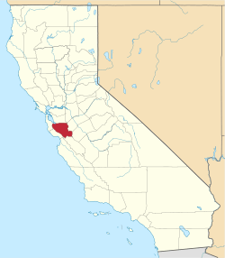 Santa Clara County map | |
| Towns | ||
| CDPs | ||
| Unincorporated communities | ||
| CCDs | ||
| Ghost towns | ||
| Bodies of water |
|  |
|---|---|---|
| Counties | ||
| Major cities | ||
| Cities and towns 100k–250k | ||
| Cities and towns 50k–99k | ||
| Cities and towns 25k–50k | ||
| Cities and towns 10k–25k |
| |
| Sub-regions | ||
| Authority control |
|
|---|
- Wang, Ying (December 21, 2015). "Native English speakers' authority in English". English Today. 32 (1): 35–40. doi:10.1017/s0266078415000516. ISSN 0266-0784.