Half Moon Bay, California
Half Moon Bay is a coastal city in San Mateo County, California, United States, located approximately 25 miles (40 km) south of San Francisco. Its population was 11,324 as of the 2010 census. Immediately at the north of Half Moon Bay is the Pillar Point Harbor and the unincorporated community of Princeton-by-the-Sea. The urban area had a population of 20,713 at the same census. Half Moon Bay is known for Mavericks, a big wave surf location.
Half Moon Bay, California HMB | |
|---|---|
City | |
| City of Half Moon Bay | |
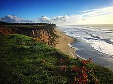
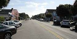 Downtown Half Moon Bay | |
 Seal | |
| Nickname(s): "Home of the world famous Half Moon Bay Pumpkin Festival!" | |
| Motto(s): Vivir, Trabajar, Jugar (Live, Work, Play) | |
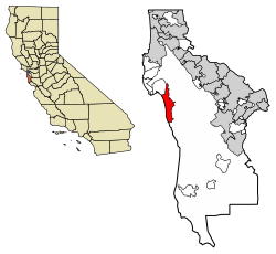 Location of Half Moon Bay in San Mateo County, California | |
 Half Moon Bay, California Location in the United States | |
| Coordinates: 37°27′32″N 122°26′13″W | |
| Country | |
| State | |
| County | |
| Incorporated | July 15, 1959[1] |
| Government | |
| • Mayor | Deborah Penrose [2] |
| • City Manager | Bob Nisbet[3] |
| Area | |
| • City | 6.44 sq mi (16.69 km2) |
| • Land | 6.42 sq mi (16.64 km2) |
| • Water | 0.02 sq mi (0.05 km2) 0.32% |
| Elevation | 75 ft (23 m) |
| Population | |
| • City | 11,324 |
| • Estimate (2019)[7] | 12,932 |
| • Density | 1,976.80/sq mi (763.27/km2) |
| • Urban | 20,713 |
| Time zone | UTC-8 (PST) |
| • Summer (DST) | UTC-7 (PDT) |
| ZIP code | 94019 |
| Area code(s) | 650 |
| FIPS code | 06-31708 |
| GNIS feature IDs | 277528, 2410685 |
| Website | www |
History
Half Moon Bay began as a rural agriculture area, primarily used for grazing of cattle, horses, and oxen used by Mission San Francisco de Asis (established in June 1776). Following the secularization of the Mission, Tiburcio Vásquez received the Rancho Corral de Tierra Mexican land grant in 1839 and Candelario Miramontes was granted Rancho Miramontes (later known as Rancho San Benito) in 1841.
The community began to develop in the 1840s as the first real town in San Mateo County. Known originally as San Benito, the town was renamed Spanishtown and attracted a thriving fishing industry in addition to its continued importance to coastal agriculture. Spanishtown became a racially diverse community, settled by Canadians, Chinese, English, Germans, Irish, Mexicans, Italians, Scots, Portuguese, and Pacific Islanders. Regular stagecoach service was established with San Mateo; coaches also served the communities of Purissima, Lobitos, and San Gregorio. Levy Brothers opened a department store in downtown Half Moon Bay. Spanishtown was officially renamed Half Moon Bay in 1874.
The area grew very slowly, even after the Ocean Shore Railroad began serving the community in 1907. The construction of Pedro Mountain Road in 1914 provided better access to San Francisco and probably contributed to the demise of the railroad by 1920. The USS DeLong ran aground at Half Moon Bay 1 December 1921. During Prohibition "rum runners" took advantage of dense fog and hidden coves in the area to serve a number of roadhouses and inns, some of which operate today as restaurants (e.g. Moss Beach Distillery). Real growth in the area came after World War II with the construction of numerous subdivisions, eventually leading to the incorporation of Half Moon Bay in 1959. The city preserves a historic downtown district which includes historic buildings dating as far back as 1869.
2008 economic downturn and subsequent recovery
In 2008, financial setbacks endangered the city's viability. The economic crisis severely affected tourism, which generates the most revenue, and that just at the time when the city had finalized an $18 million settlement over a property lawsuit. As the municipal budget was typically $14 million or less, city fathers had issued bonds with annual payments of approximately $1 million over 25 years. As a result of these combined fiscal obstacles, the threat of bankruptcy was very real. Dozens of meetings were held in order to decide where the budget should be cut and finally 75% of municipal employees were laid off and replaced with contract workers. Also, employee contributions toward retirement benefits were raised. However, the city council sought to regain the money paid in the settlement, believing that it should have been paid by the city's insurers. A lawsuit against the insurers was decided in 2013 and the insurer ordered to pay more than $13 million to the city; the costs of the lawsuit had been partially covered by the Association of Bay Area Governments.[8]
The City's finances improved afterwards. The City was able to retire the first of its two 30-year Judgment Obligation Bonds (2009A Series Bonds) a full 20 years early. The early retirement was expected to save the City over $426,000 in annual General Fund expenses starting in 2015–16.
As of the publication of the Fiscal Year 2015/16 Budget the General Fund budget was balanced and had a structural surplus of $4.0 Million.[9]
Geography
Half Moon Bay is located at 37°27′32″N 122°26′13″W,[10] approximately 25 miles (40 km) south of San Francisco, 10 miles (16 km) west of San Mateo, and 45 miles (72 km) north of Santa Cruz. Neighboring towns include El Granada, Princeton-by-the-Sea, Moss Beach, and Montara to the north and Purissima, San Gregorio, and Pescadero to the south.
According to the United States Census Bureau, the city has a total area of 6.4 square miles (17 km2), of which, 6.4 square miles (17 km2) of it is land and 0.02 square miles (0.052 km2) of it (0.32%) is water.
It is situated on a bay of the same name. Major local industries include agriculture (houseplants, floriculture, Christmas trees, pumpkins, artichokes), fishing, and tourism. Historically, Half Moon Bay had been known as San Benito and Spanishtown.
A popular spot at Half Moon Bay is the 'Jetty,' or as it is sometimes called, 'The Breakwater.' This is a man-made break with unusual waves shaped by reflections from the breakwater at Pillar Point Harbor. Streams in Half Moon Bay include Frenchmans Creek, Pilarcitos Creek and Naples Creek.
Montara State Marine Reserve & Pillar Point State Marine Conservation Area extend offshore from Montara, just north of Half Moon Bay. Like underwater parks, these marine protected areas help conserve ocean wildlife and marine ecosystems.
Climate
Half Moon Bay usually has mild weather throughout the year. Under the Köppen climate classification, Half Moon Bay has a cool summer mediterranean climate (Köppen Csb). Hot weather is rare; the average annual days with highs of 90 °F (32 °C) or higher is only 0.4 days. Cold weather is also rare with an annual average of 2.5 days with lows of 32 °F (0 °C) or lower.[11] Typical of Northern California, most of the rain falls from November to April. The normal annual precipitation is 26.2 inches (665 mm).[11] Snowfall along the coast in Half Moon Bay has never been measurable; however, snow flurries were observed on December 12, 1972, and February 5, 1976. There is often fog and overcast during the night and morning hours, usually clearing to offshore during the afternoon. Persistent sea breezes help to moderate the climate along the coast; farther from the ocean, in places such as Pilarcitos Creek, days are often warmer and nights cooler than on the coast. For the 37th parallel north, the mild summer temperatures of Half Moon Bay are unmatched across the board. Relatively nearby inland cities see significantly warmer temperatures at the same time. In spite of the low latitude and strong maritime influence, nights remain very cool even in summer.
January is the coolest month with an average high of 58.4 °F (14.7 °C) and an average low of 42.9 °F (6.1 °C). September is the warmest month with an average high of 66.8 °F (19.3 °C) and an average low of 51.2 °F (10.7 °C).[11] The highest temperature ever recorded in Half Moon Bay is 96 °F (35.6 °C), which occurred on May 16, 2008.[11] On December 3, 1983, calm conditions, low humidity, and clear skies produced a low of 18 °F (−7.8 °C).[11]
The most rainfall recorded in Half Moon Bay in one month was 15.70 inches (399 mm) in February 1998. The heaviest 24-hour rainfall was 5.33 inches (135 mm) on January 4, 1982. There is an average of 86 days with measurable rainfall.[11]
| Climate data for Half Moon Bay, California | |||||||||||||
|---|---|---|---|---|---|---|---|---|---|---|---|---|---|
| Month | Jan | Feb | Mar | Apr | May | Jun | Jul | Aug | Sep | Oct | Nov | Dec | Year |
| Record high °F (°C) | 76 (24) |
78 (26) |
86 (30) |
87 (31) |
96 (36) |
94 (34) |
84 (29) |
94 (34) |
94 (34) |
94 (34) |
87 (31) |
79 (26) |
96 (36) |
| Average high °F (°C) | 58.4 (14.7) |
59.3 (15.2) |
59.8 (15.4) |
60.7 (15.9) |
61.7 (16.5) |
63.4 (17.4) |
64.2 (17.9) |
65.1 (18.4) |
66.8 (19.3) |
65.8 (18.8) |
62.7 (17.1) |
58.9 (14.9) |
62.2 (16.8) |
| Daily mean °F (°C) | 50.6 (10.3) |
51.4 (10.8) |
51.8 (11.0) |
52.6 (11.4) |
54.6 (12.6) |
56.6 (13.7) |
58.0 (14.4) |
58.9 (14.9) |
59.1 (15.1) |
57.1 (13.9) |
54.0 (12.2) |
51.1 (10.6) |
54.7 (12.6) |
| Average low °F (°C) | 42.9 (6.1) |
43.5 (6.4) |
43.8 (6.6) |
44.6 (7.0) |
47.4 (8.6) |
49.8 (9.9) |
51.9 (11.1) |
52.7 (11.5) |
51.2 (10.7) |
48.3 (9.1) |
45.4 (7.4) |
43.3 (6.3) |
47.1 (8.4) |
| Record low °F (°C) | 27 (−3) |
22 (−6) |
28 (−2) |
31 (−1) |
33 (1) |
36 (2) |
40 (4) |
41 (5) |
35 (2) |
33 (1) |
30 (−1) |
18 (−8) |
18 (−8) |
| Average precipitation inches (mm) | 5.15 (131) |
4.49 (114) |
3.83 (97) |
1.88 (48) |
0.76 (19) |
0.30 (7.6) |
0.12 (3.0) |
0.19 (4.8) |
0.35 (8.9) |
1.59 (40) |
2.99 (76) |
4.52 (115) |
26.17 (665) |
| Average precipitation days (≥ 0.01 in) | 12 | 11 | 11 | 7 | 5 | 3 | 4 | 4 | 4 | 6 | 9 | 11 | 86 |
| Source: Western Regional Climate Center (normals and extremes 1939–present)[11] | |||||||||||||
Demographics
| Historical population | |||
|---|---|---|---|
| Census | Pop. | %± | |
| 1960 | 1,957 | — | |
| 1970 | 4,023 | 105.6% | |
| 1980 | 7,282 | 81.0% | |
| 1990 | 8,886 | 22.0% | |
| 2000 | 11,842 | 33.3% | |
| 2010 | 11,324 | −4.4% | |
| Est. 2019 | 12,932 | [7] | 14.2% |
| U.S. Decennial Census[12] | |||
2010
The 2010 United States Census[13] reported that Half Moon Bay had a population of 11,324. The population density was 1,757.1 people per square mile (678.4/km2). The racial makeup of Half Moon Bay was 8,580 (75.8%) White, 82 (0.7%) African American, 71 (0.6%) Native American, 490 (4.3%) Asian, 9 (0.1%) Pacific Islander, 1,710 (15.1%) from other races, and 382 (3.4%) from two or more races. Hispanic or Latino of any race were 3,563 persons (31.5%).
The Census reported that 11,306 people (99.8% of the population) lived in households, 18 (0.2%) lived in non-institutionalized group quarters, and 0 (0%) were institutionalized.
There were 4,149 households, out of which 1,264 (30.5%) had children under the age of 18 living in them, 2,373 (57.2%) were opposite-sex married couples living together, 293 (7.1%) had a female householder with no husband present, 156 (3.8%) had a male householder with no wife present. There were 208 (5.0%) unmarried opposite-sex partnerships, and 41 (1.0%) same-sex married couples or partnerships. 1,067 households (25.7%) were made up of individuals, and 538 (13.0%) had someone living alone who was 65 years of age or older. The average household size was 2.72. There were 2,822 families (68.0% of all households); the average family size was 3.24.
The population was spread out, with 2,533 people (22.4%) under the age of 18, 796 people (7.0%) aged 18 to 24, 2,587 people (22.8%) aged 25 to 44, 3,644 people (32.2%) aged 45 to 64, and 1,764 people (15.6%) who were 65 years of age or older. The median age was 43.2 years. For every 100 females, there were 95.1 males. For every 100 females age 18 and over, there were 93.8 males.
There were 4,395 housing units at an average density of 682.0 per square mile (263.3/km2), of which 2,944 (71.0%) were owner-occupied, and 1,205 (29.0%) were occupied by renters. The homeowner vacancy rate was 1.0%; the rental vacancy rate was 1.9%. 7,645 people (67.5% of the population) lived in owner-occupied housing units and 3,661 people (32.3%) lived in rental housing units.
2000
As of the census[14] of 2000, there were 11,842 people, 4,004 households, and 2,774 families residing in the city. The population density was 1,829.8 people per square mile (706.7/km2). There were 4,114 housing units at an average density of 635.7 per square mile (245.5/km2).
There were 4,004 households, out of which 30.9% had children under the age of 18 living with them, 58.3% were married couples living together, 7.2% had a female householder with no husband present, and 30.7% were non-families. 23.1% of all households were made up of individuals, and 9.1% had someone living alone who was 65 years of age or older. The average household size was 2.75 and the average family size was 3.20.
In the city, the population was spread out, with 22.2% under the age of 18, 8.1% from 18 to 24, 31.9% from 25 to 44, 28.2% from 45 to 64, and 9.6% who were 65 years of age or older. The median age was 39 years. For every 100 females, there were 112.8 males. For every 100 females age 18 and over, there were 115.1 males.
The median income for a household in the city was $78,473, and the median income for a family was $92,204. Males had a median income of $60,913 versus $41,265 for females. The per capita income for the city was $37,963. 6.1% of the population and 3.4% of families were below the poverty line. 7.0% of those are under the age of 18 and 6.2% of those 65 and older were living below the poverty line.
Government
In the California State Legislature, Half Moon Bay is in the 13th Senate District, represented by Democrat Jerry Hill, and in the 24th Assembly District, represented by Democrat Marc Berman.[15]
In the United States House of Representatives, Half Moon Bay is in California's 14th congressional district, represented by Democrat Jackie Speier.[16]
Fire protection for the city of Half Moon Bay is provided by the Coastside Fire Protection district,[17] which contracts for service with CalFire.[17]
Law enforcement for the City of Half Moon Bay is provided under a contract with the San Mateo County Sheriff's Office.
According to the California Secretary of State, as of February 10, 2019, Half Moon Bay has 7,549 registered voters. Of those, 3,603 (47.7%) are registered Democrats, 1,380 (18.3%) are registered Republicans, and 2,142 (28.4%) have declined to state a political party.[18]
Economy
- GoPro started in 2002 in Half Moon Bay, CA. The company moved its Headquarters to San Mateo, CA in 2012.
- Odwalla was based in Half Moon Bay. Odwalla relocated Headquarters from Half Moon Bay, CA to Dinuba, CA on May 31, 2013.
Top employers
According to the City's 2010 Comprehensive Annual Financial Report,[19] the top employers in the city at the time were:
| # | Employer | # of Employees |
|---|---|---|
| 1 | Ritz-Carlton | 550 |
| 2 | Nurserymen's Exchange | 400 |
| 3 | Bay City Flower | 340 |
| 4 | Cabrillo Unified School District | 206 |
| 5 | Half Moon Bay Golf Links | 201 |
| 6 | Sam's Chowder House | 140 |
| 7 | Ledyard Company | 120 |
| 8 | Safeway | 120 |
| 9 | Coastal Repertory Theatre | 100 |
| 10 | Ox Mountain Sanitary Landfill | 100 |
Pillar Point Harbor

The Pillar Point Harbor at the northern edge of Half Moon Bay offers a protected landing for boats and provides other marine infrastructure. In the late 1980s a new master plan was developed for the Harbor.[20] A variety of fish species have been identified in the harbor area. The most abundant fish include flatfish, particularly the speckled sanddab (Citharichthys stigmaeus) and the commercially important English sole (Parophrys vetulus), several species of rockfish (Sebastes sp.) with boccacio (S. paucispinis) most abundant, many members of the surfperch family, the most abundant being shiner (Cymanogaster aggregata) and dwarf surfperches (Micrometrus minimus), and the commercially important Pacific herring (Clupea harengus). Smaller populations of many other species, including significant commercial or sport species such as various surfperch, flatfish including halibut (Paralichthys californicus), lingcod (Ophiodon elongatus), and cabezon (Scoraenichthys marmotarus) also are found in the harbor during the summer. Abundant winter species include starry flounder (Platichthys stellatus) and topsmelt (Atherinops affinis).[21] At Pillar Point Harbor, fishermen sell crab and fish catches straight off their boats at discount prices directly to the public, and restaurants will fillet the fish for purchasers.[22]
Local attractions

The city has four sites listed at the National Register of Historic Places: the Methodist Episcopal Church at Half Moon Bay, the William Adam Simmons House,[23] the Robert Mills Dairy Barn,[24] and the James Johnston House.[25]
There is an artist's collective, Colony of Coastside Artists,[26] downtown has several galleries, and there are classes and workshops available locally.[27] Half Moon Bay also hosts an annual Art and Pumpkin Festival in October.
The remnants of the village of Purissima, perhaps the only ghost town in San Mateo County, are four miles (6.4 km) south of the city, near the junction of State Route 1 and Verde Road.
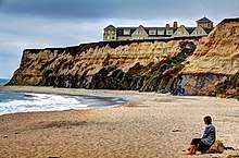
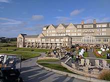
The Ritz-Carlton hotel chain operates a hotel there and is a major employer. The hotel was used as the wedding venue for the movie American Wedding.
At the north edge of the bay is the big wave surf area, Mavericks, off Pillar Point, where surfers challenge waves over 50 feet (15 m) tall. From 1999 to 2016, it was the location of the annual Titans of Mavericks competition.
The Half Moon Bay Yacht Club has facilities at the harbour.[28]
Montara Mountain, located North of Half Moon Bay, is a popular outdoor recreation spot and home to the old Highway 1.
The airport hosts an annual benefit event in April, Pacific Coast Dream Machines, which features aircraft and automobiles.[29]
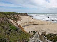
The region around Half Moon Bay contains several state parks and beaches, including:
- Half Moon Bay State Beach
- Poplar Beach
- San Gregorio State Beach
- Pomponio State Beach
- Fitzgerald Marine Reserve, located north of Half Moon Bay, a refuge for plants and animals adapted to life at the shoreline
Media
- Half Moon Bay Review, the city's only newspaper, which has been in existence since 1898.
- Coastsider, an on-line community news site.[30]
- Half Moon Bay Patch, online newspaper.[31]
Namesakes
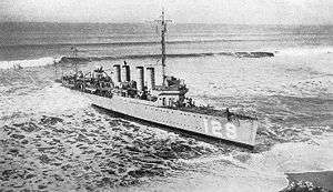
The World War II United States Navy seaplane tender USS Half Moon (AVP-26) was named for Half Moon Bay, and retained the name when serving as a United States Coast Guard weather reporting ship USCGC Half Moon for more than 20 years after the war.
The album Half Moon Bay was recorded by jazz pianist Bill Evans in 1973 at the Bach Dancing and Dynamite Society in Half Moon Bay.
Transportation
Primary road access is via State Route 1 (the Cabrillo Highway) from the north and south, and State Route 92 from the east.
The city is served by Half Moon Bay Airport.
SamTrans routes 294 and 17 provide service to Half Moon Bay from the Hillsdale Caltrain station in San Mateo and Linda Mar in Pacifica, respectively.
Education
The Cabrillo Unified School District serves the city. Schools in Half Moon Bay include Half Moon Bay High School, Cunha Middle School and Hatch Elementary School although many students are bused to other Cabrillo Unified Schools (Farallone View Elementary and El Granada Elementary) in the unincorporated area north of the City and King Mountain off Skyline Boulevard south of Highway 92.
The city is served by the Peninsula Library System.
Notable people
- Jon Miller, Hall of Fame broadcaster for the San Francisco Giants
- Charlee Minkin (born 1981), Olympic judoka
- John Montefusco, former pitcher for the San Francisco Giants and Atlanta Braves
- Jay Moriarity, surfer and free diver, youngest person to surf Mavericks, depicted in the film Chasing Mavericks
- Al Pereira, professional wrestler, twice holder of the European Heavyweight Championship
- Dorothy Wagner Puccinelli, muralist and artist[32]
- Phil Schiller, senior vice president at Apple[33]
See also
References
- "California Cities by Incorporation Date". California Association of Local Agency Formation Commissions. Archived from the original (Word) on October 17, 2013. Retrieved August 25, 2014.
- "City Council Homepage". City of Half Moon Bay. Archived from the original on September 29, 2016. Retrieved June 6, 2016.
- "Directory". City of Half Moon Bay. Archived from the original on February 27, 2015. Retrieved April 15, 2015.
- "2016 U.S. Gazetteer Files". United States Census Bureau. Retrieved Jul 19, 2017.
- "Half Moon Bay". Geographic Names Information System. United States Geological Survey. Retrieved November 5, 2014.
- "Half Moon Bay (city) QuickFacts". United States Census Bureau. Archived from the original on April 3, 2015. Retrieved April 12, 2015.
- "Population and Housing Unit Estimates". Retrieved May 21, 2020.
- The Associated Press. "Oakland tops the Yankees". San Mateo Daily Journal. Retrieved Aug 12, 2019.
- "Archived copy". Archived from the original on 2017-05-25. Retrieved 2016-06-06.CS1 maint: archived copy as title (link)
- "US Gazetteer files: 2010, 2000, and 1990". United States Census Bureau. 2011-02-12. Retrieved 2011-04-23.
- "General Climate Summary Tables - Half Moon Bay, California". Western Regional Climate Center. Retrieved December 6, 2012.
- "Census of Population and Housing". Census.gov. Retrieved June 4, 2015.
- "2010 Census Interactive Population Search: CA - Half Moon Bay city". U.S. Census Bureau. Archived from the original on July 15, 2014. Retrieved July 12, 2014.
- "U.S. Census website". United States Census Bureau. Retrieved 2008-01-31.
- "Statewide Database". UC Regents. Archived from the original on February 1, 2015. Retrieved November 29, 2014.
- "California's 14th Congressional District - Representatives & District Map". Civic Impulse, LLC. Retrieved March 13, 2013.
- "About Us | Coastside Fire Protection District". www.coastsidefire.org. Retrieved 2017-06-27.
- "CA Secretary of State – Report of Registration – February 10, 2019" (PDF). ca.gov. Retrieved March 12, 2019.
- "City of Half Moon Bay CAFR". Archived from the original on May 25, 2017. Retrieved Aug 12, 2019.
- Callander Associates, Pillar Point Harbor East Harbor Master Plan, December 21, 1988)
- Environmental Impact Report for the Pillar Point East Harbor Master Plan, Earth Metrics Inc., prepared for the San Mateo County Harbor District, February, 1989
- "FishFone". Archived from the original on 2011-11-17. Retrieved 2009-12-06.
- "National Register #92000995: William Adam Simmons House in Half Moon Bay, California". noehill.com. Retrieved 2020-01-14.
- "National Register #90000120: Mills Dairy Barn in Burleigh-Murray Ranch State Park, California". noehill.com. Retrieved 2020-01-14.
- "The White House of Half Moon Bay | The James Johnston House". www.johnstonhouse.org. Retrieved 2020-01-14.
- "Colony of Coastside Artists home page". Colony of Coastside Artists. Retrieved 2020-01-14.
- Arts On The Coastside Archived 2015-07-30 at the Wayback Machine Retrieved on 2015-05-06.
- "About". Half Moon Bay Yacht Club. Retrieved 2020-01-14.
- Pacific Coast Dream Machines, Half Moon Bay's Festival of Magnificent Machines. Miramarevents.com. Retrieved on 2013-07-21.
- "Coastsider".
- "Half Moon Bay, CA Patch - Breaking News, Local News, Events, Schools, Weather, Sports and Shopping".
- "Dorothy Puccinelli". www.askart.com. Retrieved 2016-03-14.
- "The Schiller Coastal Studies Center". features.bowdoin.edu. 2017-08-31. Retrieved 2017-09-06.
External links
| Wikivoyage has a travel guide for Half Moon Bay. |
| Wikimedia Commons has media related to Half Moon Bay, California. |
- Official website

- Half Moon Bay Chamber of Commerce & Visitors' Bureau - tourist information
- Half Moon Bay Review, newspaper serving the San Mateo County Coastside since 1898
- California State Waters Map Series—Offshore of Half Moon Bay, California United States Geological Survey
Municipalities and communities of San Mateo County, California, United States | ||
|---|---|---|
| Cities and towns | 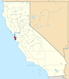 San Mateo County map | |
| CDPs | ||
| Unincorporated communities | ||
| Ghost towns | ||
| Bodies of water |
|  |
|---|---|---|
| Counties | ||
| Major cities | ||
| Cities and towns 100k–250k | ||
| Cities and towns 50k–99k | ||
| Cities and towns 25k–50k | ||
| Cities and towns 10k–25k |
| |
| Sub-regions | ||
| Authority control |
|
|---|