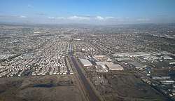
San Lorenzo, California
San Lorenzo, also known as San Lorenzo Village, is a census-designated place (CDP) located in the East Bay of the San Francisco Bay Area in Alameda County, California, United States. The population was 23,452 at the 2010 census. It is an unincorporated community, located at the banks of San Lorenzo Creek. It was originally named Squattersville in 1851, but later renamed to San Lorenzo.[6]
San Lorenzo | |
|---|---|
 | |
 Location in Alameda County and the state of California | |
 San Lorenzo Location in the United States | |
| Coordinates: 37°40′52″N 122°07′28″W | |
| Country | |
| State | |
| County | Alameda |
| Government | |
| • State Senate | Bob Wieckowski (D)[1] |
| • State Assembly | Bill Quirk (D)[2] |
| • U. S. Congress | Eric Swalwell (D)[3] |
| Area | |
| • Total | 2.770 sq mi (7.17 km2) |
| • Land | 2.763 sq mi (7.16 km2) |
| • Water | 0.007 sq mi (0.02 km2) 0.24% |
| Elevation | 36 ft (11 m) |
| Population (2010) | |
| • Total | 23,452 |
| • Density | 8,500/sq mi (3,300/km2) |
| Time zone | UTC-8 (Pacific (PST)) |
| • Summer (DST) | UTC-7 (PDT) |
| ZIP code | 94580 |
| Area code(s) | 510, 341 |
| FIPS code | 06-68112 |
| GNIS feature IDs | 232433, 1659583, 2409260 |
In 1944, under contract to the U.S. Navy, the David D. Bohannon Company began construction of San Lorenzo Village, which was one of the nation's first planned communities, with parcels designated for schools, churches, parks, and several retail centers. Bohannon's pioneering pre-cutting techniques, referred to as the "California method," were used in later developments, such as the more famous Levittown, Pennsylvania.
Geography
According to the United States Census Bureau, the CDP has a total area of 2.8 square miles (7.3 km2), of which, 2.8 square miles (7.3 km2) is land and 0.24% is water. San Lorenzo Creek runs partly through the town. It is located between the incorporated cities of San Leandro to the north and Hayward to the south.
Demographics
2010
At the 2010 census 23,452 people, 7,425 households, and 5,792 families resided in the CDP. The population density was 8,487.9 people per square mile (3,276.8/km²). There were 7,674 housing units at an average density of 2,770.4 per square mile (1,069.7/km²). The racial makeup of the CDP was 47.4% White (32.4% non-Hispanic), 4.8% African American (4.5% non-Hispanic), 1.0% Native American, 21.6% Asian, 0.8% Pacific Islander, 17.9% from other races, and 6.5% from two or more races. 37.7% of the population was Hispanic or Latino of any race.[7]
The census reported that 99.7% of the population lived in households and 0.3% lived in non-institutionalized group quarters.
Of the 7,425 households 40.0% had children under the age of 18 living in them, 56.7% were opposite-sex married couples living together, 14.7% had a female householder with no husband present, and 6.6% had a male householder with no wife present. 5.1% of households were unmarried opposite-sex partnerships and 0.7% were same-sex married couples or partnerships. 17.3% of households were one person and 9.1% were one person aged 65 or older. The average household size was 3.15 and the average family size was 3.54.
The age distribution was 24.2% under the age of 18, 9.4% aged 18 to 24, 26.9% aged 25 to 44, 26.8% aged 45 to 64, and 12.7% 65 or older. The median age was 37.9 years. For every 100 females, there were 95.3 males. For every 100 females age 18 and over, there were 91.9 males.
There were 7,674 housing units, of which 7,425 were occupied, of which 75.0% were owner-occupied and 25.0% were occupied by renters. The homeowner vacancy rate was 1.1%; the rental vacancy rate was 4.1%. 73.0% of the population lived in owner-occupied housing units and 26.7% lived in rental housing units.
2000
At the 2000 census,[8] there were 21,898 people, 7,500 households, and 5,677 families in the CDP. The population density was 7,893.4 people per square mile (3,052.3/km²). There were 7,609 housing units at an average density of 2,742.7 per square mile (1,060.6/km²).
There were 7,500 households, 34.7% had children under the age of 18 living with them, 58.1% were married couples living together, 12.6% had a female householder with no husband present, and 24.3% were non-families. 19.1% of households were one person and 11.5% were one person aged 65 or older. The average household size was 2.92 and the average family size was 3.34.
The age distribution was 25.2% under the age of 18, 8.0% from 18 to 24, 29.5% from 25 to 44, 21.3% from 45 to 64, and 16.0% 65 or older. The median age was 38 years. For every 100 females, there were 94.0 males. For every 100 females age 18 and over, there were 91.3 males.
The median household income was $66,170 and the median family income was $71,787. Males had a median income of $53,626 versus $39,531 for females. The per capita income for the CDP was $21,922. About 3.7% of families and 5.4% of the population were below the poverty line, including 6.4% of those under age 18 and 4.2% of those age 65 or over.
Government
San Lorenzo is an unincorporated community and thus is governed directly by the County of Alameda. The area is policed by the Alameda County Sheriff's Office.
History

San Lorenzo is located on the route of El Camino Viejo on land of the former Rancho San Lorenzo, a Mexican land grant given to Guillermo Castro in 1841, and the former Rancho San Leandro, granted to José Joaquin Estudillo in 1842.[9]
Early residents during the California Gold Rush era lived here as squatters along the border between Rancho San Lorenzo and Rancho San Leandro.[10] The informal name given to the area was Squatterville.[11]
The first post office opened in San Lorenzo in 1854.[12]
Many of the early inhabitants are buried in San Lorenzo Pioneer Cemetery, including Moses Wicks, who brought oysters to San Leandro Bay from Patchogue, Long Island.[13] The cemetery is maintained by the county and the Hayward Area Historical Society.
San Lorenzo was mostly farmland, a significant center of production of fruit and flowers, from the mid-19th century to the mid-20th century.
In 1944, under contract to the U.S. Navy, the David D. Bohannon Company began construction of San Lorenzo Village, a tract of two- and three-bedroom homes for workers in the East Bay's war industries. San Lorenzo Village was one of the nation's first planned communities, with parcels designated for schools, churches, parks, and several retail centers. Bohannon's pioneering pre-cutting techniques, referred to as the "California method," were used in later developments, such as the more famous Levittown, Pennsylvania. Home construction continued into the 1950s to accommodate the region's booming population.
Public education
San Lorenzo is served by the San Lorenzo Unified School District, established in 1865.
References
- "Senators". State of California. Retrieved March 18, 2013.
- "Members Assembly". State of California. Retrieved March 18, 2013.
- "California's 15th Congressional District - Representatives & District Map". Civic Impulse, LLC. Retrieved March 13, 2013.
- U.S. Census Archived 2012-07-02 at the Wayback Machine
- "San Lorenzo". Geographic Names Information System. United States Geological Survey.
- Capace, Nancy (1999). Encyclopedia of California. North American Book Dist LLC. Page 414. ISBN 9780403093182.
- "2010 Census Interactive Population Search: CA - San Lorenzo CDP". U.S. Census Bureau. Archived from the original on July 15, 2014. Retrieved July 12, 2014.
- "U.S. Census website". United States Census Bureau. Retrieved 2008-01-31.
- Ogden Hoffman, 1862, Reports of Land Cases Determined in the United States District Court for the Northern District of California, Numa Hubert, San Francisco
- "Contents: Alameda County atlas map. - David Rumsey Historical Map Collection". www.davidrumsey.com. Retrieved 2018-01-08.
- "San Lorenzo, California History". www.sanlorenzoheritage.org. Retrieved 2018-01-08.
- Durham, David L. (1998). California's Geographic Names: A Gazetteer of Historic and Modern Names of the State. Clovis, Calif.: Word Dancer Press. p. 696. ISBN 1-884995-14-4.
- California, California State Parks, State of. "SAN LEANDRO OYSTER BEDS". CA State Parks. Retrieved 2018-01-08.
External links
| Wikimedia Commons has media related to San Lorenzo, California. |
- San Lorenzo Library
- San Lorenzo Express (local news)
- San Lorenzo Village Homes Association
- Friends of San Lorenzo Creek
- San Lorenzo Area History
- Hayward Area Historical society
| Bodies of water |
|  |
|---|---|---|
| Counties | ||
| Major cities | ||
| Cities and towns 100k–250k | ||
| Cities and towns 50k–99k | ||
| Cities and towns 25k–50k | ||
| Cities and towns 10k–25k |
| |
| Sub-regions | ||
Municipalities and communities of Alameda County, California, United States | ||
|---|---|---|
| Cities | 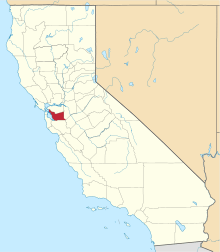 Alameda County map | |
| CDPs | ||
| Unincorporated communities | ||
| Annexed communities | ||
| Former townships |
| |
| Former communities | ||
| Authority control |
|---|