Quandary Peak
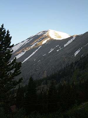
Quandary Peak is the highest summit of the Tenmile Range in the Rocky Mountains of North America and is the most commonly climbed fourteener in Colorado.[6] It has nearly the same elevation as Castle Peak and Mount Evans. It lies in Summit County and within the White River National Forest about 6 miles (10 km) south-southwest of the town of Breckenridge.
| Quandary Peak | |
|---|---|
 | |
| Highest point | |
| Elevation | 14,271 ft (4,350 m) [1][2] |
| Prominence | 1,125 ft (343 m) [3] |
| Parent peak | Mount Lincoln[3] |
| Isolation | 3.16 mi (5.09 km) [3] |
| Listing | Colorado Fourteener 13th |
| Coordinates | 39°23′50″N 106°06′23″W [1] |
| Geography | |
 Quandary Peak | |
| Location | Summit County, Colorado, U.S.[4] |
| Parent range | Mosquito Range, Highest summit of the Tenmile Range[3] |
| Topo map | USGS 7.5' topographic map Breckenridge, Colorado[1] |
| Climbing | |
| Easiest route | East Slope: Hike (class 1)[5] |
The standard route up Quandary Peak is a trail hike (class 1), starting from a trailhead about 1 mile (1.6 km) north of Hoosier Pass on the east side of the peak. Hence it is a popular fourteener to climb because of the relatively easy ascent and its proximity to Denver and Breckenridge. Quandary Peak is also popular with backcountry skiers and snowboarders. The gentle ascent makes for an easy climb from the east with less danger from avalanche than on many other fourteeners. The other slopes of the peak are steep and appeal to expert backcountry skiers.[7] One such steep ski mountaineering route is the Cristo Couloir.
References
- "QUANDARY". NGS data sheet. U.S. National Geodetic Survey. Retrieved October 21, 2014.
- The elevation of Quandary Peak includes an adjustment of +2.071 m (+6.79 ft) from NGVD 29 to NAVD 88.
- "Quandary Peak, Colorado". Peakbagger.com. Retrieved October 21, 2014.
- "Quandary Peak". Geographic Names Information System. United States Geological Survey. Retrieved October 29, 2014.
- "Quandary Peak". SummitPost.org. Retrieved 2008-11-27.
- Athearn, Lloyd F. (October 11, 2019). "2018 Hiking Use Estimates Press Release" (PDF). Colorado Fourteeners Initiative. Retrieved January 7, 2020.
- The trail climbs steadily across two marked jeep roads to your first glimpse of Quandary Peak, Hoosier Pass, and distant peaks of the Tenmile Range (.85 mile - 1.0 mile). It clears treeline and wraps to the south face of Quandary Peak's east ridge (1.0 miles : 11,721'). Dawson, Louis W., II (1994). Dawson's Guide to Colorado's Fourteeners. Volume 1. Blue Clover Press. ISBN 0-9628867-1-8.
External links
- "Quandary Peak". Distantpeak.com. Retrieved 2008-11-27.
- "Quandary Peak". 14ers.com. Retrieved 2008-11-27.
