La Plata Mountains
The La Plata Mountains are a small subrange of the San Juan Mountains in the southwestern part of Colorado, United States. They are located on the border between Montezuma and La Plata counties, about 12 miles (19 km) northwest of Durango. Their name is Spanish for silver.
| La Plata Mountains | |
|---|---|
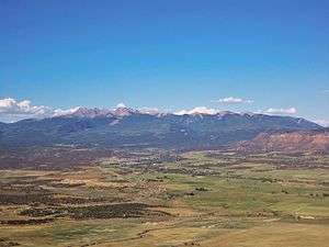 From the Mancos Valley Overlook in Mesa Verde National Park | |
| Highest point | |
| Peak | Hesperus Mountain |
| Elevation | 13,232 ft (4,033 m) |
| Coordinates | 37°27′6″N 108°0′41″W |
| Geography | |
| Country | United States |
| State | Colorado |
| Parent range | San Juan Mountains |
The peaks of the range are easily visible from U.S. Route 160, which skirts the range on the south. The La Plata River and the Mancos River have their headwaters in the range. The Colorado Trail accesses even towards the northern peaks.
The best-known and highest peak in the La Plata Mountains is Hesperus Mountain, which is the Navajo sacred mountain of the north. The six of the highest summits are listed below.
Six highest peaks
- Hesperus Mountain, 13,232 ft (4,033 m)
- Lavender Peak, 13,228 ft (4,032 m)
- Mount Moss, 13,192 ft (4,021 m)
- Babcock Peak, 13,180 ft (4,017 m)
- Centennial Peak, 13,062 ft (3,981 m)
- Burwell Peak, 12,664 ft (3,860 m)
See also
- Mountain ranges of Colorado
References
- "La Plata Mountains". Peakbagger.com.
- Colorado Atlas and Gazetteer (1st ed.), DeLorme Publishing, 1991, ISBN 0-89933-206-4.

This article is issued from Wikipedia. The text is licensed under Creative Commons - Attribution - Sharealike. Additional terms may apply for the media files.