Shetucket River
The Shetucket River is a tributary of the Thames River, 20.4 miles (32.8 km) long,[2] in eastern Connecticut in the United States.
| Shetucket River | |
|---|---|
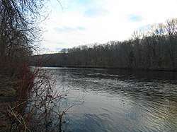 The river at Salt Rock State Park in Sprague | |
_map.jpg) Shetucket River and environs | |
| Location | |
| Country | United States |
| State | Connecticut |
| Counties | Windham, New London |
| Physical characteristics | |
| Source | Confluence of Willimantic River and Natchaug River |
| ⁃ location | Willimantic, Windham County, Connecticut, United States |
| ⁃ coordinates | 41°42′46″N 72°11′31″W[1] |
| Mouth | Confluence with Yantic River to form Thames River |
⁃ location | Norwich, New London County, Connecticut, United States |
⁃ coordinates | 41°31′20″N 72°04′40″W[1] |
| Length | 20 mi (32 km) |
| Discharge | |
| ⁃ location | Willimantic, CT |
| ⁃ average | 718 cu ft/s (20.3 m3/s)Average, 1929-2005 |
| ⁃ minimum | 337 cu ft/s (9.5 m3/s)Annual mean, 1965 |
| ⁃ maximum | 1,243 cu ft/s (35.2 m3/s)Annual mean, 1938 |
| Basin features | |
| Tributaries | |
| ⁃ right | Quinebaug River, Little River (Shetucket River) |
It is formed at Willimantic by the junction of the Willimantic and Natchaug rivers. It flows southeast and south. Approximately 4 miles (6 km) northeast of Norwich it receives the Quinebaug River and broadens into a wide estuary which stretches southeast for approximately 5 miles (8 km) and joins the Thames estuary on the south side of Norwich.
The river flows through a rural section of New England, despite the historical presence of industry in the surrounding region. Parts of the rivers have been designated by the federal government as the Quinebaug and Shetucket Rivers Valley National Heritage Corridor. The National Park Service describes the river valley as the "last green valley" in the Boston-to-Washington megalopolis. In nighttime satellite photos, the valley appears distinctively dark amidst the lights of the surrounding urban and suburban regions.
Crossings
| Carries | Location |
|---|---|
| Norwich | |
| Providence and Worcester Railroad | |
| 8th Street | |
| Providence and Worcester Railroad | Norwich/ |
| Bridge Street/Main Street | Norwich/ |
| Sprague | |
| Windham | |
| Providence and Worcester Railroad | |
| Plains Road | |
Paddling the River
The entire length of the river, as well as the lower part of the Natchaug River flowing into it, is a popular recreational paddling route.
Canoe/Kayak launch sites are located at the following locations:
- Lauter Park off Route 195 - Willimantic (on Natchaug River 1 mile above Shetucket River)
- Recreation Park on Plains Road - Windham
- Baltic Riverside Park on Route 97 - Sprague
- Occum Dam canoe portage - Sprague
- Lisbon Canoe Launch off Route 169 - Lisbon
- Greenville Dam canoe portage - Norwich
- Howard Brown Park - Norwich
Short, marked portages are required at four hydroelectric dams: Scotland Dam, Occum Dam, Taftville Dam, and Greenville Dam.
See also
- List of Connecticut rivers
References
- Geographic Names Information System, United States Geological Survey (September 12, 1979). "Geographic Names Information System Feature Detail Report: Shetucket River". Retrieved 2007-06-09.
- U.S. Geological Survey. National Hydrography Dataset high-resolution flowline data. The National Map, accessed April 1, 2011
External links
- National Park Service: Quinebaug and Shetucket Rivers Valley National Heritage Corridor
- LastGreenValley.org
- Connecticut Explorer's Guide Online Shetucket River maps
| Authority control |
|
|---|