East Aspetuck River
The East Aspetuck River is a 9.9-mile-long (15.9 km)[5] river in Litchfield County, Connecticut, in the United States. It flows in a southwesterly direction from its source at Lake Waramaug, in the town of Washington, through the villages of New Preston and Northville, before joining the West Aspetuck River in New Milford, a half a mile before emptying into the Housatonic River. It is a designated "wild trout management area," with special regulations in effect for its entire length.[3][6]
| East Aspetuck River | |
|---|---|
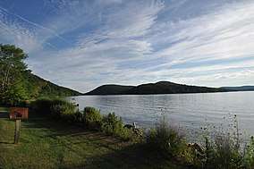 Lake Waramaug looking toward Mount Bushnell and the headwaters of the East Aspetuck River
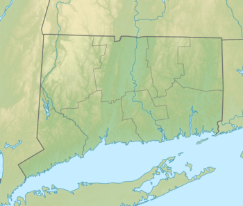 Source Mouth Source and mouth of East Aspetuck River in Connecticut | |
| Location | |
| Country | United States |
| States | Connecticut |
| Towns | Washington, New Milford |
| Physical characteristics | |
| Source | Lake Waramaug |
| ⁃ location | Washington, Massachusetts |
| ⁃ coordinates | (41°40′58″N 73°21′13″W) |
| ⁃ elevation | 692 ft (211 m) [1] |
| Mouth | West Branch Aspetuck River |
⁃ location | New Milford, Connecticut |
⁃ coordinates | (41°35′16″N 73°25′24″W) |
⁃ elevation | 203 ft (62 m) [2] |
| Length | 9.9 mi (15.9 km)[3] |
| Basin size | 16,169.24 acres (6,543.46 ha) [4] |
| Width | |
| ⁃ maximum | 30 feet (9.1 m)[3] |
| Basin features | |
| River system | Housatonic |
| Gradient | 50.80 fpm [3] |
References
- "Lake Waramaug". Geographic Names Information System. United States Geological Survey.
- "East Aapetuck River". Geographic Names Information System. United States Geological Survey.
- Maccracken, Jim (2018). "Litchfield County Connecticut Stream and River Fishing & Floating Guide". Retrieved November 7, 2019.
- "Connecticut Watersheds" (PDF). Retrieved November 7, 2019.
- U.S. Geological Survey. National Hydrography Dataset high-resolution flowline data. The National Map Archived 2012-04-05 at WebCite, accessed April 1, 2011
- "Connecticut Angler's Guide" (PDF). State of Connecticut. p. 46. Retrieved November 7, 2019.
This article is issued from Wikipedia. The text is licensed under Creative Commons - Attribution - Sharealike. Additional terms may apply for the media files.