Wilbur Cross Parkway
The Wilbur Cross Parkway is a limited access road in Connecticut, comprising the portion of Route 15 between Milford and Meriden. It is named after Wilbur Lucius Cross, a former governor of the state (1931–1939).
| |
|---|---|
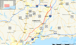 Map of New Haven County in southern Connecticut with Wilbur Cross Parkway highlighted in red | |
| Route information | |
| Length | 29.22 mi[1] (47.03 km) |
| Existed | 1941–present |
| Component highways | |
| Restrictions | No commercial vehicles, trailers, towed vehicles, buses, or hearses[2] |
| Major junctions | |
| South end | |
| North end | |
| Location | |
| Counties | New Haven |
| Highway system | |
| |

Commercial vehicles, trailers, towed vehicles (except as provided in Connecticut state law Section 14.298.240),[3] buses, hearses, and large vehicles are prohibited from using the parkway.[2] The Wilbur Cross Parkway had two toll barriers located in Milford and Wallingford until 1988.
Route description

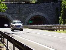
The four-lane Wilbur Cross Parkway begins as a direct continuation of the Merritt Parkway at the Sikorsky Bridge over the Housatonic River at the town line between Milford and Stratford. Immediately after is the exit for the Milford Parkway, which connects to the Connecticut Turnpike (I-95) and the Boston Post Road (US 1). The Wilbur Cross Parkway runs northeast through the towns of Milford, Orange, Woodbridge, and New Haven. At the town line between New Haven and Hamden, the parkway passes through the West Rock Tunnel, which was renamed "Heroes Tunnel" in 2003 by the State of Connecticut to honor first responders. The only road tunnel through a natural obstacle in Connecticut, it is lighted solely using low pressure sodium vapor lamps, rare in the United States. The parkway proceeds north through the towns of Hamden, North Haven, Wallingford, and Meriden. After connecting with I-91 in Meriden, the parkway ends, merging onto North Broad Street (US 5). North of Meriden, Routes 5 and 15 continue as the Berlin Turnpike.
Reflecting its history as a toll road, two pairs of service plazas lie opposite one-another along the parkway in Orange and North Haven. All were renovated since 2011, along with six further south on the Merritt Parkway. In addition to gas pumps and an Alltown convenience store at each plaza, they now include Dunkin' Donuts and Subway shops.[4] Prior to the renovations, no fast-food service had been available at any of the plazas. Three abandoned rest areas remain along the Parkway, in Woodbridge, New Haven, and Meriden.
History
The Wilbur Cross Parkway was originally planned in 1937 as route from US 1 in Milford to the Massachusetts state line in Union. The portion of the parkway south of Meriden was built largely as planned. Construction began in 1939 when federal funds were secured. The first section of the parkway to open was the Milford to Orange segment, from the Housatonic River (Exit 54) to Route 34 (Exit 57-58) at the end of 1941. Subsequent construction was delayed by World War II. After the war, two more sections of the parkway opened: the segment from US 5 in Wallingford (Exit 66) to US 5 in Meriden (Exit 68), bypassing the city center opened in 1946; and the segment from Route 10A in Hamden (Exit 61) to US 5 in Wallingford opened in 1947.
In 1948, the parkway was designated as part of a new Route 15, connecting New York to Massachusetts. Because the New Haven segment had not yet been completed, motorists were directed to temporarily follow Route 34, US 5, and Route 10A. In November 1949, the New Haven segment, from Exit 57-58 to Exit 61, including the West Rock Tunnel opened. The entire parkway was a toll road when it opened in 1941. Tolls were removed from both the Merritt and Wilbur Cross Parkways in 1988.
Exit list
Mileposts and exit numbers listed below continue from the Merritt Parkway. The entire route is in New Haven County.
| Location | mi[1] | km | Exit | Destinations | Notes | |
|---|---|---|---|---|---|---|
| Milford | 37.67 | 60.62 | – | Route 15 continues south as the Merritt Parkway into Fairfield County | ||
| 54 | Access via Milford Parkway | |||||
| 38.14– 38.66 | 61.38– 62.22 | 55A | Wheelers Farms Road | Signed as exit 55 southbound | ||
| 55B | Wolf Harbor Road | Northbound exit only | ||||
| Orange | 41.32 | 66.50 | 56 | |||
| 42.69– 43.00 | 68.70– 69.20 | 57-58 | Cloverleaf interchange; signed as exits 57 (east) and 58 (west) | |||
| New Haven | 46.57– 46.70 | 74.95– 75.16 | 59 | |||
| Woodbridge | 47.20– 47.43 | 75.96– 76.33 | Heroes Tunnel (formerly West Rock Tunnel) | |||
| Hamden | 50.00 | 80.47 | 60 | No northbound signage for New Haven | ||
| 51.72 | 83.24 | 61 | Whitney Avenue – Hamden, New Haven | Signed for Hamden exit 61 northbound and 62 southbound, New Haven exit 61 southbound | ||
| 51.82– 52.15 | 83.40– 83.93 | 62 | Dixwell Avenue | Northbound exit and entrance | ||
| North Haven | 53.45 | 86.02 | 63 | |||
| Wallingford | 58.17 | 93.62 | 64 | Wallingford | Access via South Turnpike Road / Quinnipiac Street | |
| 58.55 | 94.23 | 65 | ||||
| 61.12– 61.26 | 98.36– 98.59 | 66 | ||||
| Meriden | 63.02 | 101.42 | — | ConnDOT Maintenance Facility | Also serves Miller Avenue | |
| 64.05 | 103.08 | 67S | Southbound exit and northbound entrance; exit 17 on (I-91) north | |||
| 64.33 | 103.53 | 67W | East Main Street | Signed as exit 67 northbound | ||
| 64.63 | 104.01 | 68N-E | Northbound exit and southbound entrance, signed as exits 68N (I-91) and 68E (Route 66) | |||
| 64.95 | 104.53 | 68W | No southbound exit; exits 9-10 on I-691 | |||
| 66.89 | 107.65 | – | Continuation north | |||
| 1.000 mi = 1.609 km; 1.000 km = 0.621 mi | ||||||
References
- State of Connecticut Department of Transportation (2012). "2012 Traffic Volumes, State Maintained Highway Network" (PDF). p. 43-45. Retrieved January 27, 2020.
- "27862 Registering a Pick-up Truck with Passenger Plates". Connecticut Department of Motor Vehicles. Retrieved April 1, 2019.
- "Regulations of Connecticut State Agencies" (PDF). CT DMV. Retrieved April 1, 2019.
- "Rest Areas and Information Centers on Connecticut Highways". Connecticut Department of Transportation. Retrieved September 15, 2016.