Eads, Colorado
Eads is the Statutory Town that is the county seat and the most populous municipality of Kiowa County, Colorado, United States.[9] The town population was 609 according to the 2010 census.
Eads, Colorado | |
|---|---|
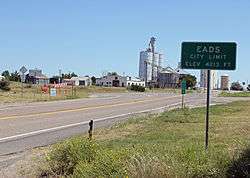 Eads from the west on State Highway 96. | |
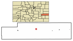 Location of Eads in Kiowa County, Colorado. | |
| Coordinates: 38°28′53″N 102°46′47″W[1] | |
| Country | |
| State | |
| County | Kiowa County Seat[2] |
| Established | 1887[3] |
| Incorporated (town) | January 29, 1916[4] |
| Government | |
| • Type | Statutory town[2] |
| Area | |
| • Total | 0.47 sq mi (1.22 km2) |
| • Land | 0.47 sq mi (1.22 km2) |
| • Water | 0.00 sq mi (0.00 km2) |
| Elevation | 4,219 ft (1,286 m) |
| Population (2010) | |
| • Total | 609 |
| • Estimate (2018)[7] | 592 |
| • Density | 1,251.06/sq mi (483.27/km2) |
| Time zone | UTC-7 (MST) |
| • Summer (DST) | UTC-6 (MDT) |
| ZIP code[8] | 81036 |
| Area code(s) | 719 |
| FIPS code | 08-22145 |
| GNIS feature ID | 0204823 |
| Website | Town of Eads |
History
Eads has been the seat of Kiowa County since 1901.[3] Eads was established in 1887 as a railroad town and was named after James Buchanan Eads, a structural engineer with the Missouri Pacific Railroad, who designed and built the Eads Bridge over the Mississippi River at St. Louis in 1874. The original name of Eads was Dayton.[10]
Geography and climate
Eads is located at 38°28′50″N 102°46′51″W (38.480465, −102.780763).[11] According to the United States Census Bureau, the town has a total area of 0.5 square miles (1.3 km2), all of it land.
| Climate data for Eads, Colorado (1981–2010) | |||||||||||||
|---|---|---|---|---|---|---|---|---|---|---|---|---|---|
| Month | Jan | Feb | Mar | Apr | May | Jun | Jul | Aug | Sep | Oct | Nov | Dec | Year |
| Record high °F (°C) | 78 (26) |
80 (27) |
90 (32) |
99 (37) |
106 (41) |
110 (43) |
110 (43) |
108 (42) |
107 (42) |
96 (36) |
86 (30) |
78 (26) |
110 (43) |
| Average high °F (°C) | 43.8 (6.6) |
47.3 (8.5) |
57.3 (14.1) |
66.2 (19.0) |
75.7 (24.3) |
86.0 (30.0) |
91.5 (33.1) |
88.6 (31.4) |
81.1 (27.3) |
68.3 (20.2) |
54.7 (12.6) |
44.0 (6.7) |
67.0 (19.4) |
| Daily mean °F (°C) | 29.2 (−1.6) |
32.7 (0.4) |
41.8 (5.4) |
50.1 (10.1) |
60.4 (15.8) |
70.4 (21.3) |
76.2 (24.6) |
74.0 (23.3) |
65.3 (18.5) |
52.0 (11.1) |
39.7 (4.3) |
29.8 (−1.2) |
51.8 (11.0) |
| Average low °F (°C) | 14.6 (−9.7) |
18.7 (−7.4) |
27.1 (−2.7) |
34.9 (1.6) |
45.3 (7.4) |
55.0 (12.8) |
60.8 (16.0) |
59.1 (15.1) |
49.7 (9.8) |
35.8 (2.1) |
24.5 (−4.2) |
15.6 (−9.1) |
36.7 (2.6) |
| Record low °F (°C) | −29 (−34) |
−19 (−28) |
−21 (−29) |
4 (−16) |
17 (−8) |
30 (−1) |
36 (2) |
38 (3) |
20 (−7) |
7 (−14) |
−12 (−24) |
−24 (−31) |
−29 (−34) |
| Average precipitation inches (mm) | 0.25 (6.4) |
0.41 (10) |
0.95 (24) |
1.51 (38) |
2.19 (56) |
2.24 (57) |
2.54 (65) |
2.66 (68) |
1.04 (26) |
1.22 (31) |
0.43 (11) |
0.41 (10) |
15.86 (403) |
| Average snowfall inches (cm) | 2.6 (6.6) |
1.9 (4.8) |
2.7 (6.9) |
1.0 (2.5) |
0.0 (0.0) |
0.0 (0.0) |
0.0 (0.0) |
0.0 (0.0) |
0.2 (0.51) |
0.0 (0.0) |
1.5 (3.8) |
2.4 (6.1) |
12.3 (31) |
| Source: NOAA[12] | |||||||||||||
Demographics
| Historical population | |||
|---|---|---|---|
| Census | Pop. | %± | |
| 1920 | 406 | — | |
| 1930 | 518 | 27.6% | |
| 1940 | 700 | 35.1% | |
| 1950 | 1,015 | 45.0% | |
| 1960 | 929 | −8.5% | |
| 1970 | 795 | −14.4% | |
| 1980 | 878 | 10.4% | |
| 1990 | 780 | −11.2% | |
| 2000 | 747 | −4.2% | |
| 2010 | 609 | −18.5% | |
| Est. 2018 | 592 | [7] | −2.8% |
| U.S. Decennial Census[13] | |||
As of the census[14] of 2000, there were 747 people, 320 households, and 193 families residing in the town. The population density was 1,579.7 people per square mile (613.7/km²). There were 389 housing units at an average density of 822.6 per square mile (319.6/km²). The racial makeup of the town was 95.85% White, 0.67% African American, 0.80% Native American, 1.47% from other races, and 1.20% from two or more races. Hispanic or Latino of any race were 2.95% of the population.
There were 320 households out of which 25.3% had children under the age of 18 living with them, 50.0% were married couples living together, 7.5% had a female householder with no husband present, and 39.4% were non-families. 35.6% of all households were made up of individuals and 20.3% had someone living alone who was 65 years of age or older. The average household size was 2.26 and the average family size was 2.93.
In the town, the population was spread out with 23.4% under the age of 18, 7.5% from 18 to 24, 24.1% from 25 to 44, 23.2% from 45 to 64, and 21.8% who were 65 years of age or older. The median age was 41 years. For every 100 females, there were 99.7 males. For every 100 females age 18 and over, there were 93.2 males.
The median income for a household in the town was $27,024, and the median income for a family was $35,625. Males had a median income of $29,375 versus $19,792 for females. The per capita income for the town was $16,944. About 7.0% of families and 12.0% of the population were below the poverty line, including 15.8% of those under age 18 and 13.5% of those age 65 or over.
Education
During the 2006–2007 school year, the Eads school district had a total of 165 students enrolled in Kindergarten through 12th grade. Eads High School had 65 students during the 2006–2007 school year. Partially because of its small size, Eads High School was the first high school in the state of Colorado to provide notebook computers for each of its students and to move to a computer-based curriculum.
See also
- Outline of Colorado
- State of Colorado
- Colorado cities and towns
- Colorado municipalities
- Colorado counties
- Colorado cities and towns
References
- "2014 U.S. Gazetteer Files: Places". United States Census Bureau. July 1, 2014. Retrieved January 6, 2015.
- "Active Colorado Municipalities". State of Colorado, Department of Local Affairs. Archived from the original on 2009-12-12. Retrieved 2007-09-01.
- "KIOWA COUNTY: THE HIGH PLAINS OF SOUTHEAST COLORADO". Archived from the original (MS Word) on 2006-10-23. Retrieved 2007-09-30.
- "Colorado Municipal Incorporations". State of Colorado, Department of Personnel & Administration, Colorado State Archives. 2004-12-01. Retrieved 2007-09-02.
- "2016 U.S. Gazetteer Files". United States Census Bureau. Retrieved Jul 25, 2017.
- "US Board on Geographic Names". United States Geological Survey. 2007-10-25. Retrieved 2008-01-31.
- "Population and Housing Unit Estimates". Retrieved March 14, 2020.
- "ZIP Code Lookup". United States Postal Service. Archived from the original (JavaScript/HTML) on November 4, 2010. Retrieved September 8, 2007.
- "Find a County". National Association of Counties. Archived from the original on 2012-07-12. Retrieved 2011-06-07.
- KiowaCountyColorado.com http://www.kiowacounty-colorado.com/eads.htm
- "US Gazetteer files: 2010, 2000, and 1990". United States Census Bureau. 2011-02-12. Retrieved 2011-04-23.
- "NOWData - NOAA Online Weather Data". National Oceanic and Atmospheric Administration. Retrieved May 5, 2013.
- "Census of Population and Housing". Census.gov. Retrieved June 4, 2015.
- "U.S. Census website". United States Census Bureau. Retrieved 2008-01-31.
External links
| Wikimedia Commons has media related to Eads, Colorado. |
- Town of Eads
- Map of Eads, CDOT
Municipalities and communities of Kiowa County, Colorado, United States | ||
|---|---|---|
| Towns |  Map of Colorado highlighting Kiowa County | |
| CDPs | ||
| Unincorporated communities | ||

| Authority control |
|
|---|