Arlington, Colorado
Arlington is an unincorporated community and U.S. Post Office in Kiowa County, Colorado, United States. The ZIP Code of the Arlington Post Office is 81021.[3]
Arlington, Colorado | |
|---|---|
 Arlington  Arlington | |
| Coordinates: 38°20′08″N 103°20′33″W | |
| Country | |
| State | |
| County | Kiowa County[1] |
| Established | 1887[2] |
| Elevation | 4,222 ft (1,287 m) |
| Time zone | UTC-7 (MST) |
| • Summer (DST) | UTC-6 (MDT) |
| ZIP Code | 81021[3] |
| Area code(s) | 719 |
| Highways | |
| GNIS feature ID | 0204825 |
History
The town of Arlington was established by the Missouri Pacific Railroad in 1887.[2] The Arlington Post Office opened on August 16, 1887.[4]
Arlington Auxiliary Army Airfield
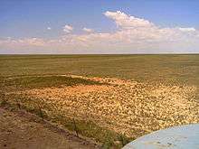
Airfield: high view from the SW corner of the triangular runway looking WNW
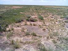
Airfield: E/W runway looking west
Three miles east of town is the site of the former Arlingtion Auxiliary Army Air Field #4,[5] one of many former Colorado World War II Army Airfields. The triangular shape of the runways is not only visible from the air, but also visible from the county road. The E/W runway still has large sections of asphalt and the vegetation has noticeable changes along the runway.
Geography
Arlington is located at 38°20′08″N 103°20′33″W (38.335597,-103.342552).
See also
- Outline of Colorado
- State of Colorado
- Colorado cities and towns
- Colorado counties
References
- "US Board on Geographic Names". United States Geological Survey. 2007-10-25. Retrieved 2008-01-31.
- Eichler, Geo. R. (1977). Colorado Place Names. 77-089726: Johnson Publishing Company.CS1 maint: location (link)
- "ZIP Code Lookup". United States Postal Service. Archived from the original (JavaScript/HTML) on 3 September 2007. Retrieved September 3, 2007.
- Bauer, William H.; James L. Ozment; John H. Willard (1990). Colorado Post Offices 1859-1989. 90-34759: The Colorado Railroad Museum. ISBN 0-918654-42-4.CS1 maint: location (link)
- Arlington Auxiliary Army Air Field #4
External links
| Wikimedia Commons has media related to Arlington, Colorado. |
Municipalities and communities of Kiowa County, Colorado, United States | ||
|---|---|---|
| Towns | 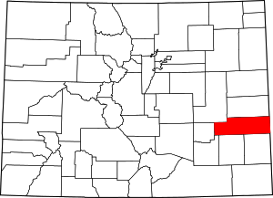 Map of Colorado highlighting Kiowa County | |
| CDPs | ||
| Unincorporated communities | ||

This article is issued from Wikipedia. The text is licensed under Creative Commons - Attribution - Sharealike. Additional terms may apply for the media files.