Alma, Colorado
Alma is a statutory town located in Park County, Colorado, United States. The town population was 270 at the 2010 United States Census.
Alma, Colorado | |
|---|---|
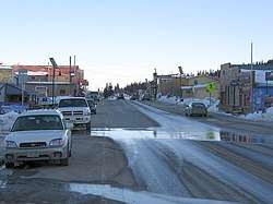 Main Street | |
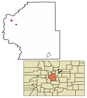 Location of Alma in Park County, Colorado. | |
| Coordinates: 39°17′09″N 106°03′59″W[1] | |
| Country | United States |
| State | Colorado |
| County[2] | Park County[3] |
| Incorporated | 1873-12-02[4] |
| Named for | Alma James[5] |
| Government | |
| • Type | Statutory Town[2] |
| Area | |
| • Total | 0.36 sq mi (0.94 km2) |
| • Land | 0.36 sq mi (0.93 km2) |
| • Water | 0.00 sq mi (0.00 km2) 0.5% |
| Elevation | 10,361 ft (3,158 m) |
| Population (2010) | |
| • Total | 270 |
| • Estimate (2018)[7] | 312 |
| • Density | 802.78/sq mi (309.91/km2) |
| Time zone | UTC-7 (MST) |
| • Summer (DST) | UTC-6 (MDT) |
| ZIP code | 80420[8] |
| Area code(s) | 719 |
| FIPS code | 08-01530 |
| GNIS feature ID | 0180003 |
| Highways | |
| Website | townofalma.com |
At an elevation of approximately 10,578 feet (3,224 m), it is the highest incorporated municipality in the United States with permanent residents.[3] Its United States Post Office is located at the highest elevation of any in the country.[9] Alma, which is a town, did not take the title as highest incorporated city from Leadville, Colorado, as is commonly believed. Leadville is the highest incorporated city in North America. Using administrative boundaries as a measure, not settled areas, in 2006 Winter Park, Colorado became the highest incorporated town due to its annexation of a ski area.[10] Alma, however, has a contiguous residential area (on Mountain View Drive) extending to 11,680 feet (3,560 m) above sea level, while any such area in or near Winter Park reaches only 9,550 feet (2,910 m), Leadville 10,360 feet (3,160 m).
The town was named by a merchant named Mr. James, after his wife.[5] Another tradition states the town was named for the daughter of a resident.[11]
Geography
Alma is located at 39°17′03″N 106°03′48″W,[12] along State Highway 9.
According to the United States Census Bureau, the town has a total area of 0.362 square miles (0.94 km2), almost all of it land.
[13] Climate
Alma's climate is subarctic (Dfc) and closely borders on an alpine climate with July average of 10.9 C.[14]
| Climate data for Alma, Colorado | |||||||||||||
|---|---|---|---|---|---|---|---|---|---|---|---|---|---|
| Month | Jan | Feb | Mar | Apr | May | Jun | Jul | Aug | Sep | Oct | Nov | Dec | Year |
| Average high °F (°C) | 24.7 (−4.1) |
28.3 (−2.1) |
33.0 (0.6) |
38.5 (3.6) |
47.2 (8.4) |
58.4 (14.7) |
63.9 (17.7) |
62.4 (16.9) |
56.2 (13.4) |
45.6 (7.6) |
32.4 (0.2) |
26.0 (−3.3) |
43.1 (6.2) |
| Average low °F (°C) | 0.6 (−17.4) |
2.1 (−16.6) |
6.8 (−14.0) |
12.8 (−10.7) |
23.3 (−4.8) |
33.0 (0.6) |
37.9 (3.3) |
37.7 (3.2) |
30.7 (−0.7) |
21.1 (−6.1) |
8.3 (−13.2) |
2.4 (−16.4) |
18.1 (−7.7) |
| Average precipitation inches (mm) | 2.04 (52) |
1.75 (44) |
2.35 (60) |
2.38 (60) |
2.10 (53) |
1.13 (29) |
2.24 (57) |
2.09 (53) |
1.49 (38) |
1.42 (36) |
1.96 (50) |
1.84 (47) |
22.79 (579) |
| Average rainfall inches (mm) | 1.9 (48) |
2.2 (56) |
2.3 (58) |
2.9 (74) |
2.6 (66) |
1.2 (30) |
2.9 (74) |
3.2 (81) |
2.4 (61) |
1.9 (48) |
1.8 (46) |
2.1 (53) |
27.4 (695) |
| Average snowfall inches (cm) | 8.1 (21) |
9.4 (24) |
12.8 (33) |
13.7 (35) |
8.9 (23) |
0.2 (0.51) |
0 (0) |
0 (0) |
1 (2.5) |
6.2 (16) |
7.3 (19) |
11.8 (30) |
79.4 (204.01) |
| Source: [14] | |||||||||||||
Demographics
| Historical population | |||
|---|---|---|---|
| Census | Pop. | %± | |
| 1880 | 446 | — | |
| 1890 | 367 | −17.7% | |
| 1900 | 297 | −19.1% | |
| 1910 | 301 | 1.3% | |
| 1920 | 127 | −57.8% | |
| 1930 | 110 | −13.4% | |
| 1940 | 469 | 326.4% | |
| 1950 | 149 | −68.2% | |
| 1960 | 107 | −28.2% | |
| 1970 | 73 | −31.8% | |
| 1980 | 132 | 80.8% | |
| 1990 | 148 | 12.1% | |
| 2000 | 179 | 20.9% | |
| 2010 | 270 | 50.8% | |
| Est. 2018 | 312 | [7] | 15.6% |
| U.S. Decennial Census[15] | |||
As of the census[16] of 2000, there were 179 people, 94 households, and 40 families residing in the town. The population density was 523.6 people per square mile (203.3/km²). There were 147 housing units at an average density of 430.0 per square mile (166.9/km²). The racial makeup of the town was 92.74% White, 2.23% Native American, 0.56% Asian, 3.35% from other races, and 1.12% from two or more races. Hispanics or Latinos of any race were 3.35% of the population.
There were 94 households, of which 18.1% had children under the age of 18 living with them, 37.2% were married couples living together, 2.1% had a female householder with no husband present, and 57.4% were non-families. 39.4% of all households were made up of individuals and 1.1% had someone living alone who was 65 years of age or older. The average household size was 1.90 and the average family size was 2.63.
The age distribution was 12.8% under the age of 18, 5.6% from 18 to 24, 53.1% from 25 to 44, 24.0% from 45 to 64, and 4.5% who were 65 years of age or older. The median age was 37 years. For every 100 females, there were 132.5 males. For every 100 females age 18 and over, there were 140.0 males.
The median income for a household in the town was $41,563, and the median income for a family was $59,688. Males had a median income of $28,750 versus $26,563 for females. The per capita income for the town was $25,165. None of the families and 4.3% of the population were living below the poverty line.
Mines
Approximately two miles from Alma are the remains of the defunct Orphan Boy mine (founded 1861), which produced gold, silver, lead, and zinc over a number of decades.[17]
The historic Sweet Home Mine near Alma, formerly a silver mine, now produces spectacular rhodochrosite mineral specimens.
Gallery
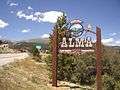 Alma Town Sign
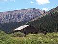 London mine building, near Alma
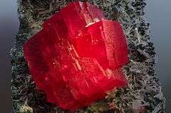 Rhodochrosite specimen from the Sweet Home mine, near Alma
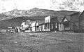 Alma, c. 1870s
See also
- Outline of Colorado
- State of Colorado
- Colorado cities and towns
- Colorado municipalities
- Colorado counties
- Colorado metropolitan areas
- Front Range Urban Corridor
- North Central Colorado Urban Area
- Denver-Aurora-Boulder, CO Combined Statistical Area
- Denver-Aurora-Broomfield, CO Metropolitan Statistical Area
- Colorado cities and towns
- List of highest towns by country
References
- "2014 U.S. Gazetteer Files: Places". United States Census Bureau. July 1, 2014. Retrieved January 5, 2015.
- "Active Colorado Municipalities". State of Colorado, Department of Local Affairs. Archived from the original on 2009-12-12. Retrieved 2007-09-01.
- "US Board on Geographic Names". United States Geological Survey. 2007-10-25. Retrieved 2008-01-31.
- "Colorado Municipal Incorporations". State of Colorado, Department of Personnel & Administration, Colorado State Archives. 2004-12-01. Archived from the original on 27 September 2007. Retrieved 2007-08-18.
- Gannett, Henry (1905). The Origin of Certain Place Names in the United States. U.S. Government Printing Office. pp. 22.
- "2016 U.S. Gazetteer Files". United States Census Bureau. Retrieved Jul 25, 2017.
- "Population and Housing Unit Estimates". Retrieved March 21, 2020.
- "ZIP Code Lookup". United States Postal Service. August 21, 2007. Retrieved June 26, 2017.
- United States Postal Service. "Fun Facts - Postal Facts".
- "Geographical Information". Town of Winter Park. Archived from the original on 2013-10-04. Retrieved 2013-10-01.
- Dawson, John Frank (1954). Place names in Colorado: why 700 communities were so named, 150 of Spanish or Indian origin. Denver, CO: The J. Frank Dawson Publishing Co. p. 6.
- "US Gazetteer files: 2010, 2000, and 1990". United States Census Bureau. 2011-02-12. Retrieved 2011-04-23.
- "National Centers for Environmental Information (NCEI) formerly known as National Climatic Data Center (NCDC) | NCEI offers access to the most significant archives of oceanic, atmospheric, geophysical and coastal data". www.ncdc.noaa.gov. Retrieved 2020-01-02.
- "Monthly Averages for Alma, Co". Archived from the original on 23 July 2011. Retrieved July 25, 2011.
- "Census of Population and Housing". Census.gov. Retrieved June 4, 2015.
- "U.S. Census website". United States Census Bureau. Retrieved 2008-01-31.
- Laura King Van Dusen, "Early Days at the Orphan Boy: Fire in December 2011 Not Only Fire at Mine; Gold Production Worth $486 Million in 2013 Dollars", Historic Tales from Park County: Parked in the Past (Charleston, South Carolina: The History Press, 2013), ISBN 978-1-62619-161-7, pp. 37-43.
External links
| Wikimedia Commons has media related to Alma, Colorado. |
- Town of Alma Website
- Alma Foundation Website
- CDOT map of the Town of Alma
- SteveGarufi.com - Alma, CO
- Ghost Town photos of Alma featured by RockyMountainProfiles.com
Municipalities and communities of Park County, Colorado, United States | ||
|---|---|---|
| Towns |  Map of Colorado highlighting Park County | |
| CDP | ||
| Unincorporated communities | ||
| Ghost towns | ||

| Authority control |
|
|---|