Grant, Colorado
Grant is an unincorporated community and a U.S. Post Office in Park County, Colorado, United States. The community is located in foothills of the Front Range in the Platte Canyon, in the upper valley of the North Fork South Platte River, approximately 6 miles (10 km) east of Kenosha Pass. It sits along U.S. Highway 285 approximately 40 miles (64 km) southwest of Denver. It consists largely of a retired general store, post office, and surrounding houses and trailers along the south side of the highway and along the north side of the river. The Grant Post Office has the ZIP Code 80448.[2] Grant is located at the mouth of Geneva Creek where it descends southward from the Front Range. County Road 62 follows the creek northward to Guanella Pass, leading to Georgetown in the canyon of Clear Creek.
Grant, Colorado | |
|---|---|
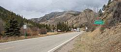 Approaching Grant from the east on U.S. Highway 285. | |
| Coordinates: 39°27′35″N 105°39′45″W | |
| Country | |
| State | |
| Counties | Park[1] |
| Elevation | 8,606 ft (2,623 m) |
| Time zone | UTC-7 (MST) |
| • Summer (DST) | UTC-6 (MDT) |
| ZIP code[2] | 80448 |
Geography
Grant is located at 39°27′35″N 105°39′45″W (39.459788,-105.662556).
References
- "US Board on Geographic Names". United States Geological Survey. 2007-10-25. Retrieved 2008-01-31.
- "ZIP Code Lookup". United States Postal Service. December 27, 2006. Archived from the original (JavaScript/HTML) on November 23, 2010. Retrieved December 27, 2006.
Municipalities and communities of Park County, Colorado, United States | ||
|---|---|---|
| Towns |  Map of Colorado highlighting Park County | |
| CDP | ||
| Unincorporated communities | ||
| Ghost towns | ||