Bédarrides
| Bédarrides | ||
|---|---|---|
| Commune | ||
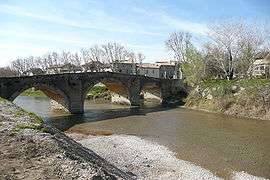 Bridge over the Ouvèze | ||
| ||
 Bédarrides Location within Provence-A.-C.d'A. region  Bédarrides | ||
| Coordinates: 44°02′29″N 4°53′55″E / 44.0414°N 4.8986°ECoordinates: 44°02′29″N 4°53′55″E / 44.0414°N 4.8986°E | ||
| Country | France | |
| Region | Provence-Alpes-Côte d'Azur | |
| Department | Vaucluse | |
| Arrondissement | Avignon | |
| Canton | Sorgues | |
| Intercommunality | Pays de Rhône et Ouvèze | |
| Government | ||
| • Mayor (2008–2014) | Joël Sérafini | |
| Area1 | 24.79 km2 (9.57 sq mi) | |
| Population (2006)2 | 5,154 | |
| • Density | 210/km2 (540/sq mi) | |
| Time zone | UTC+1 (CET) | |
| • Summer (DST) | UTC+2 (CEST) | |
| INSEE/Postal code | 84016 /84370 | |
| Elevation |
20–119 m (66–390 ft) (avg. 25 m or 82 ft) | |
|
1 French Land Register data, which excludes lakes, ponds, glaciers > 1 km2 (0.386 sq mi or 247 acres) and river estuaries. 2 Population without double counting: residents of multiple communes (e.g., students and military personnel) only counted once. | ||
.svg.png)
Bédarrides is a commune in the Vaucluse department in the Provence-Alpes-Côte d'Azur region in southeastern France.
History
As Vindalium, it was the site of the August 8, 121 BC, defeat of the Allobroges and Arverni under Bituitus by Roman legions under Q. Fabius Maximus and Gn. Domitius Ahenobarbus. This led to the establishment of the Roman province of Transalpine Gaul.
See also
References
| Wikimedia Commons has media related to Bédarrides. |
This article is issued from
Wikipedia.
The text is licensed under Creative Commons - Attribution - Sharealike.
Additional terms may apply for the media files.