Entrechaux
| Entrechaux | ||
|---|---|---|
| Commune | ||
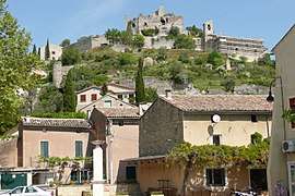 Buildings in Entrechaux | ||
| ||
 Entrechaux Location within Provence-A.-C.d'A. region  Entrechaux | ||
| Coordinates: 44°13′07″N 5°08′19″E / 44.2186°N 5.1386°ECoordinates: 44°13′07″N 5°08′19″E / 44.2186°N 5.1386°E | ||
| Country | France | |
| Region | Provence-Alpes-Côte d'Azur | |
| Department | Vaucluse | |
| Arrondissement | Carpentras | |
| Canton | Vaison-la-Romaine | |
| Intercommunality | Pays Voconces | |
| Area1 | 14.91 km2 (5.76 sq mi) | |
| Population (2006)2 | 1,000 | |
| • Density | 67/km2 (170/sq mi) | |
| Time zone | UTC+1 (CET) | |
| • Summer (DST) | UTC+2 (CEST) | |
| INSEE/Postal code | 84044 /84340 | |
| Elevation |
210–463 m (689–1,519 ft) (avg. 284 m or 932 ft) | |
|
1 French Land Register data, which excludes lakes, ponds, glaciers > 1 km2 (0.386 sq mi or 247 acres) and river estuaries. 2 Population without double counting: residents of multiple communes (e.g., students and military personnel) only counted once. | ||
.svg.png)
Entrechaux is a commune in the Vaucluse department in the Provence-Alpes-Côte d'Azur region in southeastern France.
Sights and monuments
- Château d'Entrechaux, 10th-11th-century castle ruins, open to visitors in summer.
See also
References
| Wikimedia Commons has media related to Entrechaux. |
| Wikivoyage has a travel guide for Entrechaux. |
This article is issued from
Wikipedia.
The text is licensed under Creative Commons - Attribution - Sharealike.
Additional terms may apply for the media files.