Lauris
| Lauris | ||
|---|---|---|
| Commune | ||
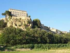 Castle of Lauris | ||
| ||
 Lauris Location within Provence-A.-C.d'A. region  Lauris | ||
| Coordinates: 43°44′52″N 5°18′49″E / 43.7478°N 5.3136°ECoordinates: 43°44′52″N 5°18′49″E / 43.7478°N 5.3136°E | ||
| Country | France | |
| Region | Provence-Alpes-Côte d'Azur | |
| Department | Vaucluse | |
| Arrondissement | Apt | |
| Canton | Cheval-Blanc | |
| Intercommunality | Portes du Luberon | |
| Government | ||
| • Mayor (2001–2008) | Monique Roustan | |
| Area1 | 21.81 km2 (8.42 sq mi) | |
| Population (2006)2 | 3,354 | |
| • Density | 150/km2 (400/sq mi) | |
| Time zone | UTC+1 (CET) | |
| • Summer (DST) | UTC+2 (CEST) | |
| INSEE/Postal code | 84065 /84360 | |
| Elevation |
128–680 m (420–2,231 ft) (avg. 350 m or 1,150 ft) | |
|
1 French Land Register data, which excludes lakes, ponds, glaciers > 1 km2 (0.386 sq mi or 247 acres) and river estuaries. 2 Population without double counting: residents of multiple communes (e.g., students and military personnel) only counted once. | ||
.svg.png)
Lauris is a commune in the Vaucluse department in the Provence-Alpes-Côte d'Azur region in southeastern France.
It is located between the Luberon and the Durance river. The town has seen a rapid increase in population in since the 1980s from 1810 inhabitants in 1982 to 3354 inhabitants in 2006.
See also
References
External links
| Wikimedia Commons has media related to Lauris. |
This article is issued from
Wikipedia.
The text is licensed under Creative Commons - Attribution - Sharealike.
Additional terms may apply for the media files.