Saint-Léger-du-Ventoux
| Saint-Léger-du-Ventoux | ||
|---|---|---|
| Commune | ||
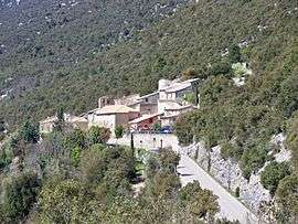 A view of Saint-Léger-du-Ventoux | ||
| ||
 Saint-Léger-du-Ventoux Location within Provence-A.-C.d'A. region  Saint-Léger-du-Ventoux | ||
| Coordinates: 44°12′47″N 5°16′34″E / 44.2131°N 5.2761°ECoordinates: 44°12′47″N 5°16′34″E / 44.2131°N 5.2761°E | ||
| Country | France | |
| Region | Provence-Alpes-Côte d'Azur | |
| Department | Vaucluse | |
| Arrondissement | Carpentras | |
| Canton | Vaison-la-Romaine | |
| Intercommunality | Vallée du Toulourenc | |
| Area1 | 19.29 km2 (7.45 sq mi) | |
| Population (2006)2 | 31 | |
| • Density | 1.6/km2 (4.2/sq mi) | |
| Time zone | UTC+1 (CET) | |
| • Summer (DST) | UTC+2 (CEST) | |
| INSEE/Postal code | 84110 /84390 | |
| Elevation |
355–1,901 m (1,165–6,237 ft) (avg. 386 m or 1,266 ft) | |
|
1 French Land Register data, which excludes lakes, ponds, glaciers > 1 km2 (0.386 sq mi or 247 acres) and river estuaries. 2 Population without double counting: residents of multiple communes (e.g., students and military personnel) only counted once. | ||
.svg.png)
Saint-Léger-du-Ventoux (Provençal: Sant Laugier dau Ventor) is a commune in the Vaucluse department in the Provence-Alpes-Côte d'Azur region in southeastern France.
See also
References
| Wikimedia Commons has media related to Saint-Léger-du-Ventoux. |
This article is issued from
Wikipedia.
The text is licensed under Creative Commons - Attribution - Sharealike.
Additional terms may apply for the media files.