Grillon
| Grillon | ||
|---|---|---|
| Commune | ||
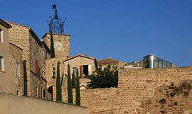 The clock tower in the village of Grillon | ||
| ||
 Grillon Location within Provence-A.-C.d'A. region  Grillon | ||
| Coordinates: 44°23′44″N 4°55′50″E / 44.3956°N 4.9306°ECoordinates: 44°23′44″N 4°55′50″E / 44.3956°N 4.9306°E | ||
| Country | France | |
| Region | Provence-Alpes-Côte d'Azur | |
| Department | Vaucluse | |
| Arrondissement | Carpentras | |
| Canton | Valréas | |
| Intercommunality | L'Enclave des Papes | |
| Government | ||
| • Mayor (2001–2008) | Daniel Magnin | |
| Area1 | 14.92 km2 (5.76 sq mi) | |
| Population (2006)2 | 1,746 | |
| • Density | 120/km2 (300/sq mi) | |
| Time zone | UTC+1 (CET) | |
| • Summer (DST) | UTC+2 (CEST) | |
| INSEE/Postal code | 84053 /84600 | |
| Elevation |
154–248 m (505–814 ft) (avg. 176 m or 577 ft) | |
|
1 French Land Register data, which excludes lakes, ponds, glaciers > 1 km2 (0.386 sq mi or 247 acres) and river estuaries. 2 Population without double counting: residents of multiple communes (e.g., students and military personnel) only counted once. | ||
.svg.png)
Grillon (Occitan: Grilhon) is a commune in the Vaucluse department in the Provence-Alpes-Côte d'Azur region in southeastern France.
It lies approximately 6 kilometres (4 miles) from the Château and village of Grignan.
International relations
Twin towns — Sister cities
Grillon is twinned with:
See also
References
| Wikimedia Commons has media related to Grillon. |
This article is issued from
Wikipedia.
The text is licensed under Creative Commons - Attribution - Sharealike.
Additional terms may apply for the media files.