Ansouis
| Ansouis | ||
|---|---|---|
| Commune | ||
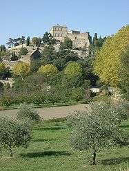 View of Ansouis | ||
| ||
 Ansouis Location within Provence-A.-C.d'A. region  Ansouis | ||
| Coordinates: 43°44′18″N 5°27′50″E / 43.7383°N 5.4638°ECoordinates: 43°44′18″N 5°27′50″E / 43.7383°N 5.4638°E | ||
| Country | France | |
| Region | Provence-Alpes-Côte d'Azur | |
| Department | Vaucluse | |
| Arrondissement | Apt | |
| Canton | Pertuis | |
| Intercommunality | Luberon-Durance | |
| Government | ||
| • Mayor (2008–2014) | Géraud de Sabran-Pontevès | |
| Area1 | 17.63 km2 (6.81 sq mi) | |
| Population (2006)2 | 1,138 | |
| • Density | 65/km2 (170/sq mi) | |
| Time zone | UTC+1 (CET) | |
| • Summer (DST) | UTC+2 (CEST) | |
| INSEE/Postal code | 84099 /84240 | |
| Elevation | 203–390 m (666–1,280 ft) | |
|
1 French Land Register data, which excludes lakes, ponds, glaciers > 1 km2 (0.386 sq mi or 247 acres) and river estuaries. 2 Population without double counting: residents of multiple communes (e.g., students and military personnel) only counted once. | ||
.png)
Ansouis (Ansoís in Occitan) is a commune in the Vaucluse department in the Provence-Alpes-Côte d'Azur region in southeastern France.
Geography
Ansouis is located between the Luberon massif and the Durance river.
History
A fortress was first built in the city in the 10th century, and has since been modified three times: once in the 13th century and again in the 15th and 19th centuries.
Demographics
The population, after peaking at 1,029 people in 1841, declined to only 463 people in 1931. It has since rebounded to 1,105 in 2006.
See also
References
| Wikimedia Commons has media related to Ansouis. |
| Authority control |
|---|
This article is issued from
Wikipedia.
The text is licensed under Creative Commons - Attribution - Sharealike.
Additional terms may apply for the media files.