Castellet
| Castellet | ||
|---|---|---|
| Commune | ||
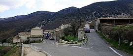 A view of the village of Castellet | ||
| ||
 Castellet Location within Provence-A.-C.d'A. region  Castellet | ||
| Coordinates: 43°50′23″N 5°28′41″E / 43.8397°N 5.478°ECoordinates: 43°50′23″N 5°28′41″E / 43.8397°N 5.478°E | ||
| Country | France | |
| Region | Provence-Alpes-Côte d'Azur | |
| Department | Vaucluse | |
| Arrondissement | Apt | |
| Canton | Apt | |
| Government | ||
| • Mayor (2001–2008) | Gabriel Tambon | |
| Area1 | 9.84 km2 (3.80 sq mi) | |
| Population (2006)2 | 109 | |
| • Density | 11/km2 (29/sq mi) | |
| Time zone | UTC+1 (CET) | |
| • Summer (DST) | UTC+2 (CEST) | |
| INSEE/Postal code | 84033 /84400 | |
| Elevation |
279–1,120 m (915–3,675 ft) (avg. 510 m or 1,670 ft) | |
|
1 French Land Register data, which excludes lakes, ponds, glaciers > 1 km2 (0.386 sq mi or 247 acres) and river estuaries. 2 Population without double counting: residents of multiple communes (e.g., students and military personnel) only counted once. | ||
.svg.png)
Castellet is a commune in the Vaucluse department in the Provence-Alpes-Côte d'Azur region in southeastern France.
Geography
The river Calavon forms all of the commune's northern border. Castellet is situated above the Côte d'Azur on a hill.
See also
References
| Wikimedia Commons has media related to Castellet (Vaucluse). |
This article is issued from
Wikipedia.
The text is licensed under Creative Commons - Attribution - Sharealike.
Additional terms may apply for the media files.