Vaugines
| Vaugines | ||
|---|---|---|
| Commune | ||
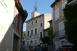 Town hall | ||
| ||
 Vaugines Location within Provence-A.-C.d'A. region  Vaugines | ||
| Coordinates: 43°46′47″N 5°24′55″E / 43.7797°N 5.4153°ECoordinates: 43°46′47″N 5°24′55″E / 43.7797°N 5.4153°E | ||
| Country | France | |
| Region | Provence-Alpes-Côte d'Azur | |
| Department | Vaucluse | |
| Arrondissement | Apt | |
| Canton | Cheval-Blanc | |
| Intercommunality | Portes du Luberon | |
| Area1 | 15.55 km2 (6.00 sq mi) | |
| Population (2006)2 | 573 | |
| • Density | 37/km2 (95/sq mi) | |
| Time zone | UTC+1 (CET) | |
| • Summer (DST) | UTC+2 (CEST) | |
| INSEE/Postal code | 84140 /84160 | |
| Elevation |
211–902 m (692–2,959 ft) (avg. 750 m or 2,460 ft) | |
|
1 French Land Register data, which excludes lakes, ponds, glaciers > 1 km2 (0.386 sq mi or 247 acres) and river estuaries. 2 Population without double counting: residents of multiple communes (e.g., students and military personnel) only counted once. | ||
.svg.png)
Vaugines is a commune in the Vaucluse department in the Provence-Alpes-Côte d'Azur region in southeastern France.
It lies on the southern slopes of the Luberon Massif. It is a very old and isolated village.
Vaugines has preserved its Provençal style, with its peaceful decorated lanes of traditional stone rural houses. The countryside surrounding Vaugines is wild and typical of Provence, and was chosen by film director Claude Berri for the filming of parts of his adaptions of Marcel Pagnol's novels Jean de Florette and Manon des Sources.
See also
References
| Wikimedia Commons has media related to Vaugines. |
| Authority control |
|---|
This article is issued from
Wikipedia.
The text is licensed under Creative Commons - Attribution - Sharealike.
Additional terms may apply for the media files.