Lamotte-du-Rhône
| Lamotte-du-Rhône | ||
|---|---|---|
| Commune | ||
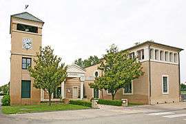 Town hall | ||
| ||
 Lamotte-du-Rhône Location within Provence-A.-C.d'A. region  Lamotte-du-Rhône | ||
| Coordinates: 44°16′01″N 4°40′51″E / 44.2669°N 4.6808°ECoordinates: 44°16′01″N 4°40′51″E / 44.2669°N 4.6808°E | ||
| Country | France | |
| Region | Provence-Alpes-Côte d'Azur | |
| Department | Vaucluse | |
| Arrondissement | Carpentras | |
| Canton | Bollène | |
| Intercommunality | Rhône-Lez-Provence | |
| Government | ||
| • Mayor | Maurice Sabater | |
| Area1 | 11.97 km2 (4.62 sq mi) | |
| Population (2006)2 | 416 | |
| • Density | 35/km2 (90/sq mi) | |
| Time zone | UTC+1 (CET) | |
| • Summer (DST) | UTC+2 (CEST) | |
| INSEE/Postal code | 84063 /84840 | |
| Elevation |
38–57 m (125–187 ft) (avg. 42 m or 138 ft) | |
|
1 French Land Register data, which excludes lakes, ponds, glaciers > 1 km2 (0.386 sq mi or 247 acres) and river estuaries. 2 Population without double counting: residents of multiple communes (e.g., students and military personnel) only counted once. | ||
.svg.png)
Lamotte-du-Rhône is a commune in the Vaucluse department in the Provence-Alpes-Côte d'Azur region in southeastern France.
See also
References
| Wikimedia Commons has media related to Lamotte-du-Rhône. |
This article is issued from
Wikipedia.
The text is licensed under Creative Commons - Attribution - Sharealike.
Additional terms may apply for the media files.