Mormoiron
| Mormoiron | ||
|---|---|---|
| Commune | ||
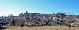 A view of Mormoiron | ||
| ||
 Mormoiron Location within Provence-A.-C.d'A. region  Mormoiron | ||
| Coordinates: 44°04′07″N 5°11′02″E / 44.0686°N 5.1839°ECoordinates: 44°04′07″N 5°11′02″E / 44.0686°N 5.1839°E | ||
| Country | France | |
| Region | Provence-Alpes-Côte d'Azur | |
| Department | Vaucluse | |
| Arrondissement | Carpentras | |
| Canton | Pernes-les-Fontaines | |
| Intercommunality | Terrasses du Ventoux | |
| Government | ||
| • Mayor (2014–2017) | SILVESTRE Régis | |
| Area1 | 25.03 km2 (9.66 sq mi) | |
| Population (2006)2 | 1,828 | |
| • Density | 73/km2 (190/sq mi) | |
| Time zone | UTC+1 (CET) | |
| • Summer (DST) | UTC+2 (CEST) | |
| INSEE/Postal code | 84082 /84570 | |
| Elevation |
179–450 m (587–1,476 ft) (avg. 281 m or 922 ft) | |
|
1 French Land Register data, which excludes lakes, ponds, glaciers > 1 km2 (0.386 sq mi or 247 acres) and river estuaries. 2 Population without double counting: residents of multiple communes (e.g., students and military personnel) only counted once. | ||
.svg.png)
Mormoiron is a commune in the Vaucluse department in the Provence-Alpes-Côte d'Azur region in southeastern France.
Geography and geology
Mormoiron is located 12 km East of Carpentras; also nearby are Mont Ventoux and Avignon. The soil is mainly composed of sand, ochre and gypsum.
The Village
Prehistory and antiquity
The commune's area was occupied prehistorically (approximately 100,000 BC), as is evidenced by the discovery of bifaces and Pottery. Evidence from the twenty-first century BC points to trade relations with Phocaea and ancient Marseille.
Roman colonization left behind altars to Mercury, coins from the Augustan and Trojan reigns, and various other artefacts.
See also
References
| Wikimedia Commons has media related to Mormoiron. |
This article is issued from
Wikipedia.
The text is licensed under Creative Commons - Attribution - Sharealike.
Additional terms may apply for the media files.