Sérignan-du-Comtat
| Sérignan-du-Comtat | ||
|---|---|---|
| Commune | ||
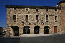 The town hall of Sérignan-du-Comtat | ||
| ||
 Sérignan-du-Comtat Location within Provence-A.-C.d'A. region  Sérignan-du-Comtat | ||
| Coordinates: 44°11′24″N 4°50′39″E / 44.19°N 4.8442°ECoordinates: 44°11′24″N 4°50′39″E / 44.19°N 4.8442°E | ||
| Country | France | |
| Region | Provence-Alpes-Côte d'Azur | |
| Department | Vaucluse | |
| Arrondissement | Carpentras | |
| Canton | Bollène | |
| Intercommunality | Aygues Ouvèze en Provence | |
| Government | ||
| • Mayor | Jean Collado | |
| Area1 | 19.82 km2 (7.65 sq mi) | |
| Population (2006)2 | 2,490 | |
| • Density | 130/km2 (330/sq mi) | |
| Time zone | UTC+1 (CET) | |
| • Summer (DST) | UTC+2 (CEST) | |
| INSEE/Postal code | 84127 /84830 | |
| Elevation |
53–240 m (174–787 ft) (avg. 80 m or 260 ft) | |
|
1 French Land Register data, which excludes lakes, ponds, glaciers > 1 km2 (0.386 sq mi or 247 acres) and river estuaries. 2 Population without double counting: residents of multiple communes (e.g., students and military personnel) only counted once. | ||
.svg.png)
Sérignan-du-Comtat is a commune in the Vaucluse department in the Provence-Alpes-Côte d'Azur region in southeastern France.
Points of interest
- Harmas de Fabre
- Musée-Atelier Werner Lichtner-Aix [1]
See also
References
| Wikimedia Commons has media related to Sérignan-du-Comtat. |
This article is issued from
Wikipedia.
The text is licensed under Creative Commons - Attribution - Sharealike.
Additional terms may apply for the media files.