Mérindol
For the French doctor, see Antoine Mérindol (1570-1624)
| Mérindol | ||
|---|---|---|
| Commune | ||
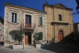 Town hall and church | ||
| ||
 Mérindol Location within Provence-A.-C.d'A. region  Mérindol | ||
| Coordinates: 43°45′24″N 5°12′14″E / 43.7567°N 5.2039°ECoordinates: 43°45′24″N 5°12′14″E / 43.7567°N 5.2039°E | ||
| Country | France | |
| Region | Provence-Alpes-Côte d'Azur | |
| Department | Vaucluse | |
| Arrondissement | Apt | |
| Canton | Cheval-Blanc | |
| Intercommunality | Provence Luberon Durance | |
| Government | ||
| • Mayor (2008–2014) | Philippe Batoux | |
| Area1 | 26.59 km2 (10.27 sq mi) | |
| Population (2006)2 | 1,962 | |
| • Density | 74/km2 (190/sq mi) | |
| Time zone | UTC+1 (CET) | |
| • Summer (DST) | UTC+2 (CEST) | |
| INSEE/Postal code | 84074 /84360 | |
| Elevation |
100–620 m (330–2,030 ft) (avg. 168 m or 551 ft) | |
|
1 French Land Register data, which excludes lakes, ponds, glaciers > 1 km2 (0.386 sq mi or 247 acres) and river estuaries. 2 Population without double counting: residents of multiple communes (e.g., students and military personnel) only counted once. | ||
.svg.png)
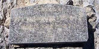
Mérindol plaque "In memory of the Waldensians who died for their faith" − commemorating victims of the 16th century Massacre of Mérindol.
Mérindol is a commune in the Vaucluse department in the Provence-Alpes-Côte d'Azur region in southeastern France.
History
Points of interest
See also
References
| Wikimedia Commons has media related to Mérindol. |
This article is issued from
Wikipedia.
The text is licensed under Creative Commons - Attribution - Sharealike.
Additional terms may apply for the media files.