Bollène
| Bollène Bouleno | ||
|---|---|---|
| Commune | ||
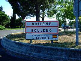 Entrance of Bollène. The second sign shows the town name in Provençal. The third one its twin town. | ||
| ||
 Bollène Location within Provence-A.-C.d'A. region  Bollène | ||
| Coordinates: 44°16′52″N 4°44′58″E / 44.2811°N 4.7494°ECoordinates: 44°16′52″N 4°44′58″E / 44.2811°N 4.7494°E | ||
| Country | France | |
| Region | Provence-Alpes-Côte d'Azur | |
| Department | Vaucluse | |
| Arrondissement | Carpentras | |
| Canton | Bollène | |
| Intercommunality | Rhône-Lez-Provence | |
| Government | ||
| • Mayor (2008–2014) | Marie-Claude Bompard | |
| Area1 | 54.03 km2 (20.86 sq mi) | |
| Population (2006)2 | 14,148 | |
| • Density | 260/km2 (680/sq mi) | |
| Time zone | UTC+1 (CET) | |
| • Summer (DST) | UTC+2 (CEST) | |
| INSEE/Postal code | 84019 /84500 | |
| Elevation |
42–312 m (138–1,024 ft) (avg. 55 m or 180 ft) | |
|
1 French Land Register data, which excludes lakes, ponds, glaciers > 1 km2 (0.386 sq mi or 247 acres) and river estuaries. 2 Population without double counting: residents of multiple communes (e.g., students and military personnel) only counted once. | ||

Bollène (Provençal: Bouleno) is a commune in the Vaucluse department in the Provence-Alpes-Côte d'Azur region in southeastern France.
Twin towns
See also
- Communes of the Vaucluse department
- Tricastin Nuclear Power Center
- Félix Charpentier. Sculptor of Bollène War Memorial
References
| Wikimedia Commons has media related to Bollène. |
This article is issued from
Wikipedia.
The text is licensed under Creative Commons - Attribution - Sharealike.
Additional terms may apply for the media files.