Villars, Vaucluse
| Villars | ||
|---|---|---|
| Commune | ||
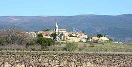 View of Villars with vineyards | ||
| ||
 Villars Location within Provence-A.-C.d'A. region  Villars | ||
| Coordinates: 43°55′27″N 5°24′22″E / 43.9242°N 5.4061°ECoordinates: 43°55′27″N 5°24′22″E / 43.9242°N 5.4061°E | ||
| Country | France | |
| Region | Provence-Alpes-Côte d'Azur | |
| Department | Vaucluse | |
| Arrondissement | Apt | |
| Canton | Apt | |
| Government | ||
| • Mayor (2008–2014) | Alain Massel | |
| Area1 | 30.05 km2 (11.60 sq mi) | |
| Population (2006)2 | 739 | |
| • Density | 25/km2 (64/sq mi) | |
| Time zone | UTC+1 (CET) | |
| • Summer (DST) | UTC+2 (CEST) | |
| INSEE/Postal code | 84145 /84400 | |
| Elevation |
247–1,184 m (810–3,885 ft) (avg. 300 m or 980 ft) | |
|
1 French Land Register data, which excludes lakes, ponds, glaciers > 1 km2 (0.386 sq mi or 247 acres) and river estuaries. 2 Population without double counting: residents of multiple communes (e.g., students and military personnel) only counted once. | ||
.svg.png)
Villars (Occitan: Lo Vilar) is a commune in the Vaucluse department in the Provence-Alpes-Côte d'Azur region in southeastern France.
See also
References
| Wikimedia Commons has media related to Villars, Vaucluse. |
This article is issued from
Wikipedia.
The text is licensed under Creative Commons - Attribution - Sharealike.
Additional terms may apply for the media files.