Le Beaucet
| Le Beaucet | ||
|---|---|---|
| Commune | ||
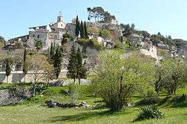 View of Le Beaucet | ||
| ||
 Le Beaucet Location within Provence-A.-C.d'A. region  Le Beaucet | ||
| Coordinates: 43°59′05″N 5°07′13″E / 43.9847°N 5.1203°ECoordinates: 43°59′05″N 5°07′13″E / 43.9847°N 5.1203°E | ||
| Country | France | |
| Region | Provence-Alpes-Côte d'Azur | |
| Department | Vaucluse | |
| Arrondissement | Carpentras | |
| Canton | Pernes-les-Fontaines | |
| Intercommunality | Ventoux-Comtat Venaissin | |
| Government | ||
| • Mayor (2013-2014) | Michèle Morel | |
| Area1 | 9.04 km2 (3.49 sq mi) | |
| Population (2006)2 | 375 | |
| • Density | 41/km2 (110/sq mi) | |
| Time zone | UTC+1 (CET) | |
| • Summer (DST) | UTC+2 (CEST) | |
| INSEE/Postal code | 84011 /84210 | |
| Elevation |
169–665 m (554–2,182 ft) (avg. 245 m or 804 ft) | |
|
1 French Land Register data, which excludes lakes, ponds, glaciers > 1 km2 (0.386 sq mi or 247 acres) and river estuaries. 2 Population without double counting: residents of multiple communes (e.g., students and military personnel) only counted once. | ||
.svg.png)
Le Beaucet (Occitan: Lo Baucet) is a commune in the Vaucluse department in the Provence-Alpes-Côte d'Azur region in southeastern France. The village is located just between the Monts of Vaucluse and the Luberon valley.
See also
Le Beaucet is a small settlement located in the South of France.
References
| Wikimedia Commons has media related to Le Beaucet. |
This article is issued from
Wikipedia.
The text is licensed under Creative Commons - Attribution - Sharealike.
Additional terms may apply for the media files.