Rustrel
| Rustrel | ||
|---|---|---|
| Commune | ||
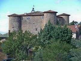 Château de Rustrel, which houses the town hall | ||
| ||
 Rustrel Location within Provence-A.-C.d'A. region  Rustrel | ||
| Coordinates: 43°55′31″N 5°29′09″E / 43.9253°N 5.4858°ECoordinates: 43°55′31″N 5°29′09″E / 43.9253°N 5.4858°E | ||
| Country | France | |
| Region | Provence-Alpes-Côte d'Azur | |
| Department | Vaucluse | |
| Arrondissement | Apt | |
| Canton | Apt | |
| Intercommunality | pays d'Apt | |
| Government | ||
| • Mayor (2001–2008) | Pierre Rimele | |
| Area1 | 28.26 km2 (10.91 sq mi) | |
| Population (2006)2 | 672 | |
| • Density | 24/km2 (62/sq mi) | |
| Time zone | UTC+1 (CET) | |
| • Summer (DST) | UTC+2 (CEST) | |
| INSEE/Postal code | 84103 /84400 | |
| Elevation |
279–1,073 m (915–3,520 ft) (avg. 422 m or 1,385 ft) | |
|
1 French Land Register data, which excludes lakes, ponds, glaciers > 1 km2 (0.386 sq mi or 247 acres) and river estuaries. 2 Population without double counting: residents of multiple communes (e.g., students and military personnel) only counted once. | ||
.svg.png)
Rustrel is a commune in the Vaucluse department in the Provence-Alpes-Côte d'Azur region in southeastern France.
Sights
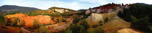
This village is famous for its ochre, which many people come to visit in the French Colorado.

Panoramic of the French Colorado.
Panoramic of the French Colorado.
See also
References
| Wikimedia Commons has media related to Rustrel. |
This article is issued from
Wikipedia.
The text is licensed under Creative Commons - Attribution - Sharealike.
Additional terms may apply for the media files.