Saint-Saturnin-lès-Apt
| Saint-Saturnin-lès-Apt | ||
|---|---|---|
| Commune | ||
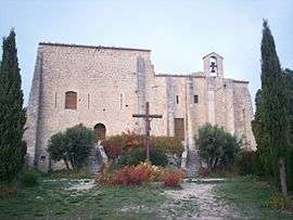 Chapel of the castle of Saint-Saturnin-lès-Apt | ||
| ||
 Saint-Saturnin-lès-Apt Location within Provence-A.-C.d'A. region  Saint-Saturnin-lès-Apt | ||
| Coordinates: 43°56′42″N 5°23′04″E / 43.945°N 5.3844°ECoordinates: 43°56′42″N 5°23′04″E / 43.945°N 5.3844°E | ||
| Country | France | |
| Region | Provence-Alpes-Côte d'Azur | |
| Department | Vaucluse | |
| Arrondissement | Apt | |
| Canton | Apt | |
| Government | ||
| • Mayor (2008–2014) | Chritian Bellot | |
| Area1 | 75.79 km2 (29.26 sq mi) | |
| Population (2008)2 | 2,637 | |
| • Density | 35/km2 (90/sq mi) | |
| Time zone | UTC+1 (CET) | |
| • Summer (DST) | UTC+2 (CEST) | |
| INSEE/Postal code | 84118 /84490 | |
| Elevation |
217–1,093 m (712–3,586 ft) (avg. 411 m or 1,348 ft) | |
|
1 French Land Register data, which excludes lakes, ponds, glaciers > 1 km2 (0.386 sq mi or 247 acres) and river estuaries. 2 Population without double counting: residents of multiple communes (e.g., students and military personnel) only counted once. | ||
.svg.png)
Saint-Saturnin-lès-Apt is a commune in the Vaucluse department in the Provence-Alpes-Côte d'Azur region in southeastern France.
Twin towns

See also
Gallery
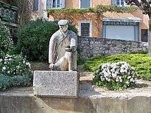 Statue of Joseph Talon, in Saint-Saturnin-lès-Apt
References
| Wikimedia Commons has media related to Saint-Saturnin-lès-Apt. |
| Authority control |
|---|
This article is issued from
Wikipedia.
The text is licensed under Creative Commons - Attribution - Sharealike.
Additional terms may apply for the media files.