Flassan
| Flassan | ||
|---|---|---|
| Commune | ||
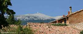 Mont Ventoux over the roofs of Flassan | ||
| ||
 Flassan Location within Provence-A.-C.d'A. region  Flassan | ||
| Coordinates: 44°05′59″N 5°14′33″E / 44.0997°N 5.2425°ECoordinates: 44°05′59″N 5°14′33″E / 44.0997°N 5.2425°E | ||
| Country | France | |
| Region | Provence-Alpes-Côte d'Azur | |
| Department | Vaucluse | |
| Arrondissement | Carpentras | |
| Canton | Pernes-les-Fontaines | |
| Intercommunality | Ventoux-Comtat Venaissin | |
| Area1 | 20.6 km2 (8.0 sq mi) | |
| Population (2006)2 | 411 | |
| • Density | 20/km2 (52/sq mi) | |
| Time zone | UTC+1 (CET) | |
| • Summer (DST) | UTC+2 (CEST) | |
| INSEE/Postal code | 84046 /84410 | |
| Elevation |
337–1,058 m (1,106–3,471 ft) (avg. 437 m or 1,434 ft) | |
|
1 French Land Register data, which excludes lakes, ponds, glaciers > 1 km2 (0.386 sq mi or 247 acres) and river estuaries. 2 Population without double counting: residents of multiple communes (e.g., students and military personnel) only counted once. | ||
.svg.png)
Flassan (Flaçan in Occitan) is a commune in the Vaucluse department in the Provence-Alpes-Côte d'Azur region in southeastern France.
Geography
Flassan is located at the foot of Mont Ventoux.
Demography
| |||||||||||||||||||||||||||
See also
References
| Wikimedia Commons has media related to Flassan. |
| Wikivoyage has a travel guide for Flassan. |
This article is issued from
Wikipedia.
The text is licensed under Creative Commons - Attribution - Sharealike.
Additional terms may apply for the media files.