Vanylven
| Vanylven kommune | ||
|---|---|---|
| Municipality | ||
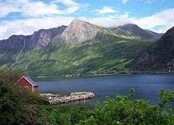 View of the Vanylvsfjorden from Eidså | ||
| ||
 Vanylven within Sogn og Fjorande | ||
| Coordinates: 62°03′38″N 05°41′51″E / 62.06056°N 5.69750°ECoordinates: 62°03′38″N 05°41′51″E / 62.06056°N 5.69750°E | ||
| Country | Norway | |
| County | Sogn og Fjorande | |
| District | Sunnmøre | |
| Administrative centre | Fiskåbygd | |
| Government | ||
| • Mayor (2015) | Lena Landsverk Sande (V) | |
| Area | ||
| • Total | 385.21 km2 (148.73 sq mi) | |
| • Land | 365.28 km2 (141.04 sq mi) | |
| • Water | 19.93 km2 (7.70 sq mi) | |
| Area rank | #243 in Norway | |
| Population (2017) | ||
| • Total | 3,203 | |
| • Rank | #257 in Norway | |
| • Density | 8.8/km2 (23/sq mi) | |
| • Change (10 years) | -9.4% | |
| Demonym(s) | Vanylving[1] | |
| Time zone | UTC+01:00 (CET) | |
| • Summer (DST) | UTC+02:00 (CEST) | |
| ISO 3166 code | NO-1511 | |
| Official language form | Nynorsk | |
| Website |
www | |

Vanylven is a municipality in Møre og Romsdal county, Norway. It is part of the Sunnmøre region. The administrative centre is the village of Fiskåbygd. Other villages in the municipality include Sandnes, Åheim, Åram, Rovdane, Eidså, Slagnes, and Myklebost.
The 385-square-kilometre (149 sq mi) municipality is the 243rd largest by area out of the 422 municipalities in Norway. Vanylven is the 257th most populous municipality in Norway with a population of 3,203. The municipality's population density is 8.8 inhabitants per square kilometre (23/sq mi) and its population has decreased by 9.4% over the last decade.[2]
General information

The parish of Vanelven was established as a municipality on 1 January 1838 (see formannskapsdistrikt). The spelling was later changed to Vanylven. On 1 July 1918, the area around the Syvdsfjorden was separated to become the new Syvde municipality. This left Vanylven with 1,848 residents. Then on 1 January 1964, Syvde municipality and the Rovdestranda area of Rovde municipality were both merged into Vanylven Municipality. This gave Vanylven a new population of 3,897. On 1 January 2002, the mainland Åram area north of Fiskåbygd (population: 380) was transferred from Sande Municipality to Vanylven Municipality.[3][4]
Name
The municipality is named after Vanylvsfjorden (Old Norse: Vaniflir). The meaning of the first element is unknown, but the last element (-iflir) is also found in the names Sunnylven and Sykkylven and it probably means "fjord".[5]
Before 1889, the name was written "Vanelven", from 1889-1917 it was spelled "Vannelven", and since 1918 it has been spelled "Vanylven".
Coat-of-arms
The coat-of-arms is from modern times; they were granted on 11 December 1987. The arms are meant to show how the Vanylvsfjorden meets the sea, surrounded by the fertile green lands of Vanylven. The fertile lands and the sea which is full of herring are both important industries to the municipality.[6][7]
Churches
The Church of Norway has four parishes (sokn) within the municipality of Vanylven. It is part of the Søre Sunnmøre deanery in the Diocese of Møre.
| Parish (Sokn) | Church Name | Location of the Church | Year Built |
|---|---|---|---|
| Vanylven | Vanylven Church | Slagnes | 1863 |
| Syvde | Syvde Church | Myklebost | 1837 |
| Rovde | Rovde Church | Rovdane | 1872 |
| Åram | Åram Church | Åram | 1927 |
| Åheim | Saint Jetmund Church | Åheim | 1130 |
Geography

Vanylven borders the municipalities of Sande and Herøy in the north (across the Rovdefjorden). Volda Municipality lies to the east; and the municipalities of Eid, Vågsøy and Selje (in Sogn og Fjordane county) are located to the south.
Vanylven is located on the mainland of Norway and it is surrounded by several fjords. The Vanylvsfjorden lies to the west and the Rovdefjorden to the north. The Syvdsfjorden cuts into the municipality from the north and it empties into the Rovdefjorden. The Syltefjorden branches off the main Vanylvsfjorden, just past the village of Fiskåbygd.
Government
All municipalities in Norway, including Vanylven, are responsible for primary education (through 10th grade), outpatient health services, senior citizen services, unemployment and other social services, zoning, economic development, and municipal roads. The municipality is governed by a municipal council of elected representatives, which in turn elect a mayor.
Municipal council
The municipal council (Kommunestyre) of Vanylven is made up of 21 representatives that are elected to four year terms. Currently, the party breakdown is as follows:[8]
| Party Name | Name in Norwegian | Number of representatives | |
|---|---|---|---|
| Labour Party | Arbeiderpartiet | 5 | |
| Progress Party | Framstegspartiet | 3 | |
| Conservative Party | Høgre | 3 | |
| Christian Democratic Party | Kristelig Folkeparti | 3 | |
| Centre Party | Senterpartiet | 3 | |
| Liberal Party | Venstre | 4 | |
| Total number of members: | 21 | ||
References
- ↑ "Navn på steder og personer: Innbyggjarnamn" (in Norwegian). Språkrådet. Retrieved 2015-12-01.
- ↑ Statistisk sentralbyrå (2017). "Table: 06913: Population 1 January and population changes during the calendar year (M)" (in Norwegian). Retrieved 2017-10-19.
- ↑ Jukvam, Dag (1999). "Historisk oversikt over endringer i kommune- og fylkesinndelingen" (PDF) (in Norwegian). Statistisk sentralbyrå.
- ↑ Statistisk sentralbyrå (2001). "1511 Vanylven. Population 1 January and population changes during the year. 1951-" (in Norwegian).
- ↑ Rygh, Oluf (1908). Norske gaardnavne: Romsdals amt (in Norwegian) (13 ed.). Kristiania, Norge: W. C. Fabritius & sønners bogtrikkeri. p. 1.
- ↑ "Om Vanylven" (in Norwegian). Retrieved 2008-10-18.
- ↑ "Civic heraldry of Norway - Norske Kommunevåpen". Heraldry of the World. Retrieved 2017-10-19.
- ↑ "Table: 04813: Members of the local councils, by party/electoral list at the Municipal Council election (M)" (in Norwegian). Statistics Norway. 2015.
| Wikimedia Commons has media related to Vanylven. |
| Wikivoyage has a travel guide for Møre og Romsdal. |
External links
- Municipal fact sheet from Statistics Norway (in Norwegian)
- http://www.vanylven.kommune.no (in Norwegian)