Slagnes
| Slagnes | |
|---|---|
| Village | |
 Slagnes Location in Møre og Romsdal  Slagnes Slagnes (Norway) | |
| Coordinates: 62°04′30″N 05°31′23″E / 62.07500°N 5.52306°ECoordinates: 62°04′30″N 05°31′23″E / 62.07500°N 5.52306°E | |
| Country | Norway |
| Region | Western Norway |
| County | Møre og Romsdal |
| District | Sunnmøre |
| Municipality | Vanylven Municipality |
| Elevation[1] | 19 m (62 ft) |
| Time zone | UTC+01:00 (CET) |
| • Summer (DST) | UTC+02:00 (CEST) |
| Post Code | 6146 Åheim |
Slagnes is a village in Vanylven Municipality in Møre og Romsdal county, Norway. The village is located along the Vanylvsfjorden, about 4 kilometres (2.5 mi) south of the village of Åheim. Slagnes is a small peninsula that sits about 3.5 kilometres (2.2 mi) across the fjord from the municipal centre of Fiskåbygd. The small village is the site of Vanylven Church.
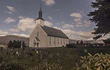
View of Vanylven Church in Slagnes
References
- ↑ "Slagnes, Vanylven" (in Norwegian). yr.no. Retrieved 2013-08-29.
This article is issued from
Wikipedia.
The text is licensed under Creative Commons - Attribution - Sharealike.
Additional terms may apply for the media files.