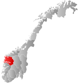
Eid, Norway
| Eid kommune | |||
|---|---|---|---|
| Municipality | |||
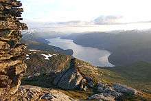
 View of the Eidsfjorden | |||
| |||
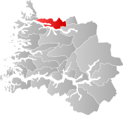 Eid within Sogn og Fjordane | |||
| Coordinates: 61°54′41″N 06°02′14″E / 61.91139°N 6.03722°ECoordinates: 61°54′41″N 06°02′14″E / 61.91139°N 6.03722°E | |||
| Country | Norway | ||
| County | Sogn og Fjordane | ||
| District | Nordfjord | ||
| Administrative centre | Nordfjordeid | ||
| Government | |||
| • Mayor (2011) | Alfred Bjørlo (V) | ||
| Area | |||
| • Total | 469.22 km2 (181.17 sq mi) | ||
| • Land | 420.20 km2 (162.24 sq mi) | ||
| • Water | 49.02 km2 (18.93 sq mi) | ||
| Area rank | #215 in Norway | ||
| Population (2017) | |||
| • Total | 6,064 | ||
| • Rank | #171 in Norway | ||
| • Density | 14.4/km2 (37/sq mi) | ||
| • Change (10 years) | 3.7% | ||
| Demonym(s) |
Eidar Eider[1] | ||
| Time zone | UTC+01:00 (CET) | ||
| • Summer (DST) | UTC+02:00 (CEST) | ||
| ISO 3166 code | NO-1443 | ||
| Official language form | Nynorsk | ||
| Website |
www | ||
Eid is a municipality in the county of Sogn og Fjordane, Norway. It is located in the traditional district of Nordfjord. The village of Nordfjordeid is the administrative center of the municipality. Other larger villages in Eid include Mogrenda, Stårheim, Haugen, Kjølsdalen, Heggjabygda, and Lote
The 469-square-kilometre (181 sq mi) municipality is the 215th largest by area out of the 422 municipalities in Norway. Eid is the 171st most populous municipality in Norway with a population of 6,064. The municipality's population density is 14.4 inhabitants per square kilometre (37/sq mi) and its population has increased by 3.7% over the last decade.[2]
Eid is known for its opera, fjord horses, shopping, and hiking opportunities. As in the rest of the region, agriculture is very important here, but trade and industry are also important. Frislid Konfeksjon (textiles) and the Hellesøy Nordfjord shipyard among others are located in Eid.
Nordfjordeid has much to offer in the way of education. Its schools include the folk high school, which offers courses linked to Fjord horses and provides the only circus education in Norway. There is also the Norwegian Fjord Horse Centre (Norsk Fjordhestsenter) in Eid. Its focus is in boosting the breed's standing in Norway and elsewhere.[3]
General information

Eid was established as a municipality on 1 January 1838 (see formannskapsdistrikt). The original municipality was identical to the Eid parish (prestegjeld) with the sub-parishes (sokn) of Hornindal, Eid, and Stårheim.[4] On 1 January 1867, the eastern district of Hornindal was separated from Eid to form its own municipality. This split left the two remaining sub-parishes of the municipality of Eid with a population of 2,918.[5]
During the 1960s, there were many municipal mergers across Norway due to the work of the Schei Committee. On 1 January 1965, the neighboring municipalities of Davik and Hornindal were dissolved and split up among their neighbors. Eid municipality gained all of Davik that was north of the Nordfjorden and east of and including the village of Lefdal. (Population in that area was 654.[5]) All of Hornindal municipality west of and including the villages of Navelsaker and Holmøyvik (population: 310) was also merged into Eid. After this merger, Eid's total population was 4,532.[5] At this point, Eid gained a third sub-parish from the former municipality of Davik: Kjølsdalen. Then on 1 January 1992, the village of Lote and its surrounding area (population: 152) was transferred from Gloppen Municipality to Eid.[5]
On 1 January 2020, the municipalities of Eid and Selje will merge to form the new municipality of Stad.[6] It is possible that the Bryggja area of Vågsøy Municipality will also be part of Stad municipality, but those discussions are ongoing with the Vågsøy council saying no, but the residents of that area saying yes.[7][8]
Name
The Old Norse form of the name was Øygir; this was originally the name of a fjord (now called the Eidsfjorden). The name of the fjord is probably derived from a river name Aug, and this again is derived from the word öfugr which means "backwards". The actual river (now called Eidselva) meanders back and forth and from certain points it can seem to run backwards.
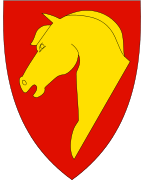
Coat of arms
The coat of arms were granted on 26 April 1986. The arms show the golden head of a fjord horse on a red background. The region is well known for its own race of horses, called the Fjording, that are very common and popular in the area. The Fjording is characterised by its white and black mane.[9]
Churches
The Church of Norway has three parishes (sokn) within the municipality of Eid. It is part of the Nordfjord deanery in the Diocese of Bjørgvin. [4][10]
| Parish (Sokn) | Church Name | Location of the Church | Year Built |
|---|---|---|---|
| Eid | Eid Church | Nordfjordeid | 1849 |
| Heggjabygda Church | Heggjabygda | 1936 | |
| Kjølsdalen | Kjølsdalen Church | Kjølsdalen | 1940 |
| Stårheim | Stårheim Church | Stårheim | 1864 |
Government
All municipalities in Norway, including Eid, are responsible for primary education (through 10th grade), outpatient health services, senior citizen services, unemployment and other social services, zoning, economic development, and municipal roads. The municipality is governed by a municipal council of elected representatives, which in turn elect a mayor.
Municipal council
The municipal council (Kommunestyre) of Eid is made up of 29 representatives that are elected to four year terms. Currently, the party breakdown is as follows:[11]
| Party Name | Name in Norwegian | Number of representatives | |
|---|---|---|---|
| Labour Party | Arbeiderpartiet | 4 | |
| Progress Party | Framstegspartiet | 1 | |
| Conservative Party | Høgre | 4 | |
| Christian Democratic Party | Kristelig Folkeparti | 1 | |
| Centre Party | Senterpartiet | 9 | |
| Socialist Left Party | Sosialistisk Venstreparti | 1 | |
| Liberal Party | Venstre | 9 | |
| Total number of members: | 29 | ||
Mayor
The mayor (ordførar) of a municipality in Norway is a representative of the majority party of the municipal council who is elected to lead the council. Alfred Bjørlo of the Liberal Party was elected mayor for the 2011-2015 term and was re-elected for the 2015-2019 term.[12]
Geography
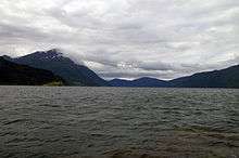

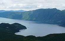
The municipality of Eid is located in the northernmost part of Sogn og Fjordane county. It is located along the northern shores of the Nordfjorden and it surrounds the Eidsfjorden branch off of the main Nordfjorden. Eid is bordered to the west by the municipality of Vågsøy, to the south by the municipalities of Bremanger and Gloppen, to the east by the municipalities of Stryn and Hornindal, and to the north by the municipalities of Volda and Vanylven in Møre og Romsdal county. Hornindalsvatnet, the deepest lake in Europe, is partially located in Eid municipalithy.
Famous people
- Ronny Hafsås, biathlete
- Thor-Inge Hoddevik, founder and guitarist of The School
- Karl-Martin Hoddevik, founder and bass player of The School and Svelekameratane
- Azar Karadaş, football player
- Sophus Lie (1842–1899), mathematician
- Jan-Ketil Smørdal, founder and director, Cirkus Agora
- Harald Aabrekk, soccer coach
- Stig Førde Aarskog, founder and guitarist/singer of The School
References
- ↑ "Navn på steder og personer: Innbyggjarnamn" (in Norwegian). Språkrådet. Retrieved 2015-12-01.
- ↑ Statistisk sentralbyrå (2017). "Table: 06913: Population 1 January and population changes during the calendar year (M)" (in Norwegian). Retrieved 2017-10-21.
- ↑ "Eid". Nordfjord.info. Archived from the original on 21 July 2011. Retrieved 2 August 2008.
- 1 2 Natvik, Oddvar (9 February 2005). "Some historical data on the 26 Kommunes". Archived from the original on 24 July 2011.
- 1 2 3 4 Juvkam, Dag (1999). "Historisk oversikt over endringer i kommune- og fylkesinndelingen" (PDF) (in Norwegian). Statistics Norway.
- ↑ "Stad 2020: Eid og Selje i ny kommune" (in Norwegian). Retrieved 2017-10-21.
- ↑ Wuttudal, Anna (2017-10-20). "Vågsøy vil ikkje gje slepp". Fjordabladet (in Norwegian). Retrieved 2017-10-21.
- ↑ Gytri, Anna; Blaalid Oldeide, Erlend (2017-09-23). "Vil la folk på Bryggja skifte kommune". NRK Sogn og Fjordane (in Norwegian). Retrieved 2017-10-21.
- ↑ Norske Kommunevåpen (1990). "Nye kommunevåbener i Norden". Retrieved 2 August 2008.
- ↑ "Eid kirkelige fellesråd" (in Norwegian). Den Norske Kirke.
- ↑ "Table: 04813: Members of the local councils, by party/electoral list at the Municipal Council election (M)" (in Norwegian). Statistics Norway. 2015.
- ↑ Eid Kommune. "Ordføraren" (in Norwegian). Archived from the original on 16 February 2012. Retrieved 2 August 2008.
External links
| Wikimedia Commons has media related to Eid, Norway. |

- Municipal fact sheet from Statistics Norway (in Norwegian)