Toulx-Sainte-Croix
| Toulx-Sainte-Croix | |
|---|---|
| Commune | |
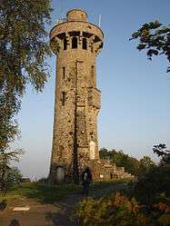 Observation tower | |
 Toulx-Sainte-Croix Location within Nouvelle-Aquitaine region  Toulx-Sainte-Croix | |
| Coordinates: 46°17′08″N 2°12′52″E / 46.2856°N 2.2144°ECoordinates: 46°17′08″N 2°12′52″E / 46.2856°N 2.2144°E | |
| Country | France |
| Region | Nouvelle-Aquitaine |
| Department | Creuse |
| Arrondissement | Guéret |
| Canton | Boussac |
| Intercommunality | CC Creuse Confluence |
| Government | |
| • Mayor (2008–2014) | Bernard De La Biche |
| Area1 | 35.05 km2 (13.53 sq mi) |
| Population (2008)2 | 299 |
| • Density | 8.5/km2 (22/sq mi) |
| Time zone | UTC+1 (CET) |
| • Summer (DST) | UTC+2 (CEST) |
| INSEE/Postal code | 23254 /23600 |
| Elevation |
375–656 m (1,230–2,152 ft) (avg. 655 m or 2,149 ft) |
|
1 French Land Register data, which excludes lakes, ponds, glaciers > 1 km2 (0.386 sq mi or 247 acres) and river estuaries. 2 Population without double counting: residents of multiple communes (e.g., students and military personnel) only counted once. | |
Toulx-Sainte-Croix is a commune in the Creuse department in the Nouvelle-Aquitaine region in central France.
Geography
An area of forestry and farming, comprising the village and several hamlets situated some 16 miles (26 km) northeast of Guéret, at the junction of the D67 and the D14 roads.
Population
| Historical population | ||
|---|---|---|
| Year | Pop. | ±% |
| 1962 | 495 | — |
| 1968 | 570 | +15.2% |
| 1975 | 507 | −11.1% |
| 1982 | 435 | −14.2% |
| 1990 | 361 | −17.0% |
| 1999 | 304 | −15.8% |
| 2008 | 299 | −1.6% |
Sights
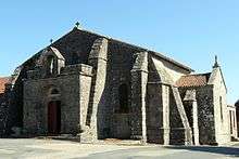
The Romanesque church
- Several Roman remains.
- The church and its separate bell tower, dating from the eleventh century.
- The ancient stone cross on the square.
- Megaliths known as "Les Pierres Jaumâtres".
- A fifteenth-century château at the hamlet of Maisons.
- A fortified manorhouse at Chanon.
- The observation tower constructed in 1932 by Abbé Aguillaume.
See also
References
External links
| Wikimedia Commons has media related to Toulx-Sainte-Croix. |
| Authority control |
|---|
This article is issued from
Wikipedia.
The text is licensed under Creative Commons - Attribution - Sharealike.
Additional terms may apply for the media files.