Le Grand-Bourg
| Le Grand-Bourg | ||
|---|---|---|
| Commune | ||
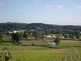 The village of Grand-Bourg seen from the village of Ardannes, the Gartempe river is in the foreground | ||
| ||
 Le Grand-Bourg Location within Nouvelle-Aquitaine region  Le Grand-Bourg | ||
| Coordinates: 46°09′39″N 1°38′43″E / 46.1608°N 1.6453°ECoordinates: 46°09′39″N 1°38′43″E / 46.1608°N 1.6453°E | ||
| Country | France | |
| Region | Nouvelle-Aquitaine | |
| Department | Creuse | |
| Arrondissement | Guéret | |
| Canton | Le Grand-Bourg | |
| Intercommunality | CC Monts et Vallées Ouest Creuse | |
| Government | ||
| • Mayor (2008–2014) | Mireille Ricard | |
| Area1 | 78.91 km2 (30.47 sq mi) | |
| Population (2008)2 | 1,196 | |
| • Density | 15/km2 (39/sq mi) | |
| Time zone | UTC+1 (CET) | |
| • Summer (DST) | UTC+2 (CEST) | |
| INSEE/Postal code | 23095 /23240 | |
| Elevation |
344–497 m (1,129–1,631 ft) (avg. 389 m or 1,276 ft) | |
|
1 French Land Register data, which excludes lakes, ponds, glaciers > 1 km2 (0.386 sq mi or 247 acres) and river estuaries. 2 Population without double counting: residents of multiple communes (e.g., students and military personnel) only counted once. | ||

Le Grand-Bourg is a commune in the Creuse department in the Nouvelle-Aquitaine region in central France.
Geography
An area of farming and forestry comprising the village and a few small hamlets situated some 12 miles (19 km) west of Guéret at the junction of the D4, D52 and the D912 road, the pilgrimage route known as St James's Way. The Gartempe River flows through the middle of the commune’s territory.
Population
| Historical population | ||
|---|---|---|
| Year | Pop. | ±% |
| 1962 | 1,672 | — |
| 1968 | 1,861 | +11.3% |
| 1975 | 1,564 | −16.0% |
| 1982 | 1,369 | −12.5% |
| 1990 | 1,323 | −3.4% |
| 1999 | 1,244 | −6.0% |
| 2008 | 1,196 | −3.9% |
Sights
- The chateau de Collonges, dating from the eighteenth century.
- The ruins of the chateau du Seigneur.
- The eighteenth-century presbytery.
- The thirteenth-century church.
- A watermill.
- An eighteenth-century chapel.
Set on a hilltop with a 360 degree views overlooking Le Creuse countryside, sits the oldest and most historic castle in the Limousin region is Chateau Du Masgelier, originally built as a medieval defence castle in 1174 dating back to the Knights Templar and once owned by King Louis XIV, the south turret bares the crest of the Fleur De Lis.
See also
References
External links
- Le Grand-Bourg on the Quid website (in French)
| Wikimedia Commons has media related to Le Grand-Bourg. |