Sainte-Feyre-la-Montagne
| Sainte-Feyre-la-Montagne | |
|---|---|
| Commune | |
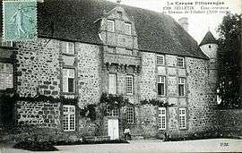 The Château of Villefort | |
 Sainte-Feyre-la-Montagne Location within Nouvelle-Aquitaine region  Sainte-Feyre-la-Montagne | |
| Coordinates: 45°53′59″N 2°14′00″E / 45.8997°N 2.2333°ECoordinates: 45°53′59″N 2°14′00″E / 45.8997°N 2.2333°E | |
| Country | France |
| Region | Nouvelle-Aquitaine |
| Department | Creuse |
| Arrondissement | Aubusson |
| Canton | Felletin |
| Intercommunality | CC Creuse Grand Sud |
| Government | |
| • Mayor (2008–2014) | Gervais Bialoux |
| Area1 | 6.84 km2 (2.64 sq mi) |
| Population (2008)2 | 118 |
| • Density | 17/km2 (45/sq mi) |
| Time zone | UTC+1 (CET) |
| • Summer (DST) | UTC+2 (CEST) |
| INSEE/Postal code | 23194 /23500 |
| Elevation | 540–688 m (1,772–2,257 ft) |
|
1 French Land Register data, which excludes lakes, ponds, glaciers > 1 km2 (0.386 sq mi or 247 acres) and river estuaries. 2 Population without double counting: residents of multiple communes (e.g., students and military personnel) only counted once. | |
Sainte-Feyre-la-Montagne is a commune in the Creuse department in central France.
Population
| Historical population | ||
|---|---|---|
| Year | Pop. | ±% |
| 1962 | 133 | — |
| 1968 | 138 | +3.8% |
| 1975 | 133 | −3.6% |
| 1982 | 144 | +8.3% |
| 1990 | 144 | +0.0% |
| 1999 | 122 | −15.3% |
| 2008 | 118 | −3.3% |
See also
References
| Wikimedia Commons has media related to Sainte-Feyre-la-Montagne. |
| Authority control |
|---|
This article is issued from
Wikipedia.
The text is licensed under Creative Commons - Attribution - Sharealike.
Additional terms may apply for the media files.