Bétête
| Bétête | |
|---|---|
| Commune | |
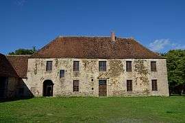 Abbey of Prébenoît | |
 Bétête Location within Nouvelle-Aquitaine region  Bétête | |
| Coordinates: 46°21′37″N 2°04′42″E / 46.3603°N 2.0783°ECoordinates: 46°21′37″N 2°04′42″E / 46.3603°N 2.0783°E | |
| Country | France |
| Region | Nouvelle-Aquitaine |
| Department | Creuse |
| Arrondissement | Guéret |
| Canton | Boussac |
| Intercommunality | CC Creuse Confluence |
| Government | |
| • Mayor (2008–2014) | Olivier Contarin |
| Area1 | 28.24 km2 (10.90 sq mi) |
| Population (2008)2 | 359 |
| • Density | 13/km2 (33/sq mi) |
| Time zone | UTC+1 (CET) |
| • Summer (DST) | UTC+2 (CEST) |
| INSEE/Postal code | 23022 /23270 |
| Elevation |
272–430 m (892–1,411 ft) (avg. 380 m or 1,250 ft) |
|
1 French Land Register data, which excludes lakes, ponds, glaciers > 1 km2 (0.386 sq mi or 247 acres) and river estuaries. 2 Population without double counting: residents of multiple communes (e.g., students and military personnel) only counted once. | |
Bétête is a commune in the Creuse department in the Nouvelle-Aquitaine region in central France.
Geography
A farming area comprising the village and several hamlets situated some 15 miles (24 km) northeast of Guéret, at the junction of the D15, D83 and the D88. The Petite Creuse river forms most of the southern and western border of the commune.
Population
| Historical population | ||
|---|---|---|
| Year | Pop. | ±% |
| 1962 | 666 | — |
| 1968 | 668 | +0.3% |
| 1975 | 651 | −2.5% |
| 1982 | 638 | −2.0% |
| 1990 | 525 | −17.7% |
| 1999 | 427 | −18.7% |
| 2008 | 359 | −15.9% |
Sights
See also
References
External links
- Bétête on the Quid website (in French)
| Wikimedia Commons has media related to Bétête. |
This article is issued from
Wikipedia.
The text is licensed under Creative Commons - Attribution - Sharealike.
Additional terms may apply for the media files.