Maisonnisses
| Maisonnisses | |
|---|---|
| Commune | |
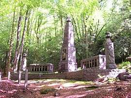 Monument to Resistance fighters | |
 Maisonnisses Location within Nouvelle-Aquitaine region  Maisonnisses | |
| Coordinates: 46°03′49″N 1°53′59″E / 46.0636°N 1.8997°ECoordinates: 46°03′49″N 1°53′59″E / 46.0636°N 1.8997°E | |
| Country | France |
| Region | Nouvelle-Aquitaine |
| Department | Creuse |
| Arrondissement | Guéret |
| Canton | Ahun |
| Intercommunality | CC Creuse Sud Ouest |
| Government | |
| • Mayor (2008–2014) | Serge Meaume |
| Area1 | 11.12 km2 (4.29 sq mi) |
| Population (2008)2 | 207 |
| • Density | 19/km2 (48/sq mi) |
| Time zone | UTC+1 (CET) |
| • Summer (DST) | UTC+2 (CEST) |
| INSEE/Postal code | 23118 /23150 |
| Elevation |
517–685 m (1,696–2,247 ft) (avg. 500 m or 1,600 ft) |
|
1 French Land Register data, which excludes lakes, ponds, glaciers > 1 km2 (0.386 sq mi or 247 acres) and river estuaries. 2 Population without double counting: residents of multiple communes (e.g., students and military personnel) only counted once. | |
Maisonnisses is a commune in the Creuse department in the Nouvelle-Aquitaine region in central France.
Geography
A farming and forestry area comprising the village and some small hamlets, situated some 8 miles (13 km) south of Guéret at the junction of the D50, D60 and the D34 roads. The small river Gartempe flows through the middle of the commune.
Population
| Historical population | ||
|---|---|---|
| Year | Pop. | ±% |
| 1962 | 252 | — |
| 1968 | 284 | +12.7% |
| 1975 | 265 | −6.7% |
| 1982 | 189 | −28.7% |
| 1990 | 206 | +9.0% |
| 1999 | 213 | +3.4% |
| 2008 | 207 | −2.8% |
Sights
- The church of Saint-Jean-Baptiste, dating from the fourteenth century.
- A war memorial.
See also
References
External links
- Maisonnisses on the Quid website (in French)
| Wikimedia Commons has media related to Maisonnisses. |
This article is issued from
Wikipedia.
The text is licensed under Creative Commons - Attribution - Sharealike.
Additional terms may apply for the media files.