Châtelard, Creuse
| Châtelard | |
|---|---|
| Commune | |
 Châtelard Location within Nouvelle-Aquitaine region  Châtelard | |
| Coordinates: 45°57′54″N 2°28′08″E / 45.965°N 2.4689°ECoordinates: 45°57′54″N 2°28′08″E / 45.965°N 2.4689°E | |
| Country | France |
| Region | Nouvelle-Aquitaine |
| Department | Creuse |
| Arrondissement | Aubusson |
| Canton | Auzances |
| Intercommunality | CC Chénérailles, Auzances/Bellegarde et Haut Pays Marchois |
| Government | |
| • Mayor (2008–2014) | Daniel Raillard |
| Area1 | 2.42 km2 (0.93 sq mi) |
| Population (2008)2 | 34 |
| • Density | 14/km2 (36/sq mi) |
| Time zone | UTC+1 (CET) |
| • Summer (DST) | UTC+2 (CEST) |
| INSEE/Postal code | 23055 /23700 |
| Elevation |
597–726 m (1,959–2,382 ft) (avg. 503 m or 1,650 ft) |
|
1 French Land Register data, which excludes lakes, ponds, glaciers > 1 km2 (0.386 sq mi or 247 acres) and river estuaries. 2 Population without double counting: residents of multiple communes (e.g., students and military personnel) only counted once. | |
Châtelard is a commune in the Creuse department in the Nouvelle-Aquitaine region in central France.
Geography
The smallest commune of the department; a farming village situated some 13 miles (21 km) east of Aubusson on the D27a road.
Population
| Historical population | ||
|---|---|---|
| Year | Pop. | ±% |
| 1962 | 48 | — |
| 1968 | 38 | −20.8% |
| 1975 | 30 | −21.1% |
| 1982 | 23 | −23.3% |
| 1990 | 35 | +52.2% |
| 1999 | 39 | +11.4% |
| 2008 | 34 | −12.8% |
Sights
Personalities
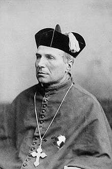
Jean-Francois Jamot (1828–1886) was born here. He became the first bishop of Peterborough, Ontario, Canada.
See also
References
External links
| Wikimedia Commons has media related to Châtelard. |
- Châtelard on the Quid website (in French)
This article is issued from
Wikipedia.
The text is licensed under Creative Commons - Attribution - Sharealike.
Additional terms may apply for the media files.