Gouzon
| Gouzon | ||
|---|---|---|
| Commune | ||
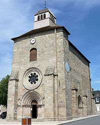 The church of Saint-Martin, in Gouzon | ||
| ||
 Gouzon Location within Nouvelle-Aquitaine region  Gouzon | ||
| Coordinates: 46°11′33″N 2°14′22″E / 46.1925°N 2.2394°ECoordinates: 46°11′33″N 2°14′22″E / 46.1925°N 2.2394°E | ||
| Country | France | |
| Region | Nouvelle-Aquitaine | |
| Department | Creuse | |
| Arrondissement | Guéret | |
| Canton | Gouzon | |
| Intercommunality | CC Creuse Confluence | |
| Government | ||
| • Mayor (2001–2008) | Cyril Victor | |
| Area1 | 50.03 km2 (19.32 sq mi) | |
| Population (2008)2 | 1,475 | |
| • Density | 29/km2 (76/sq mi) | |
| Time zone | UTC+1 (CET) | |
| • Summer (DST) | UTC+2 (CEST) | |
| INSEE/Postal code | 23093 /23230 | |
| Elevation |
366–476 m (1,201–1,562 ft) (avg. 378 m or 1,240 ft) | |
|
1 French Land Register data, which excludes lakes, ponds, glaciers > 1 km2 (0.386 sq mi or 247 acres) and river estuaries. 2 Population without double counting: residents of multiple communes (e.g., students and military personnel) only counted once. | ||

Gouzon is a commune in the Creuse department in central France.
Geography
Gouzon straddles the N145 between Montluçon and Gueret
The village lies on the left bank of the Voueize, which flows northwest through the commune.
Population
| Historical population | ||
|---|---|---|
| Year | Pop. | ±% |
| 1962 | 1,580 | — |
| 1968 | 1,639 | +3.7% |
| 1975 | 1,501 | −8.4% |
| 1982 | 1,469 | −2.1% |
| 1990 | 1,370 | −6.7% |
| 1999 | 1,381 | +0.8% |
| 2008 | 1,475 | +6.8% |
The inhabitants are known as Gouzonnais.
Sights
- 13th-century church with a shingle-covered steeple.
- Church of St. Nicolas of the Forge (5 km) - Some medieval frescos.
- Étang de Grands-Champs – Fly-fishing lake
- Étang des Landes - 120 Hectares nature reserve. Bird Observatory
Economy
Gouzon is also a cheese made in the Limousin region.
See also
References
External links
| Wikimedia Commons has media related to Gouzon. |
This article is issued from
Wikipedia.
The text is licensed under Creative Commons - Attribution - Sharealike.
Additional terms may apply for the media files.